Blairstown Township’s post office opened in 1839, and 21% of its homes were built before 1940
More historic than 92% of U.S. towns · #45 of 468 in New Jersey. What drives it
2 places in town are on the National Register, among them two historic districts with 184 buildings between them. Below: 4 old photos and papers, maps from 1943 on, and the census since 1850.
From Blairstown Township’s archive · credits on each photo
Quick answers
How Blairstown Township began
When was Blairstown Township founded?
1839
The Blairstown Township post office opened in 1839, the earliest record of the town by name. Wikidata gives 1845. Five smaller post offices, Butt's Bridge (1820), Gravel Hill (1825) and Walnut Valley (1828), opened inside today’s town and later closed.
First census: 1,405 in 18502020 census: 5,704187 years
How historic is Blairstown Township?
A
More historic than 92% of U.S. towns, on its age, its old homes and the National Register.
Founding year: the first Blairstown Township post office (Blevins & Helbock, CC0). Wikidata: 1845.
History grade
What drives Blairstown Township’s History grade
On its age, its old homes and the National Register, Blairstown Township is more historic than 92% of U.S. towns, #45 of 468 in New Jersey. All 3 inputs are above most U.S. towns; its National Register listings ranks highest and its share of homes from before 1940 lowest.
A
HistoryA character grade: shown, never part of Blairstown Township’s overall grade.
New Jersey towns list more on the Register than most of the country (a typical New Jersey town has 3.7 per 10,000 residents, the U.S. 2.4), so Blairstown Township’s 321 sits above most of its state (93% of New Jersey towns have fewer) while its 184 historic buildings outnumber those of 93% of U.S. towns.
How sure. Graded on any two of the three inputs instead, the letter would range from A− to A. The pre-1940 share is a Census survey estimate (±9.4 points). The founding year is the first post office, not a stated founding date; Wikidata’s 1845 falls in the same era, so the grade doesn’t depend on which one is used.
Founding year: the first post office (other dates in Quick answers). Homes: Census ACS 2020–24. National Register: National Park Service, May 2026 list; each listing counted once (boundary changes and added documentation belong to their listing), and a historic district counts its contributing buildings. How TownRatings grades history →
What stands out about Blairstown Township’s past
Read from the archive, the National Register and the record. The page puts what stands out first.
Wikipedia doesn’t have a history of Blairstown Township yet. The photos, dates and memories neighbors add here are how it gets written.
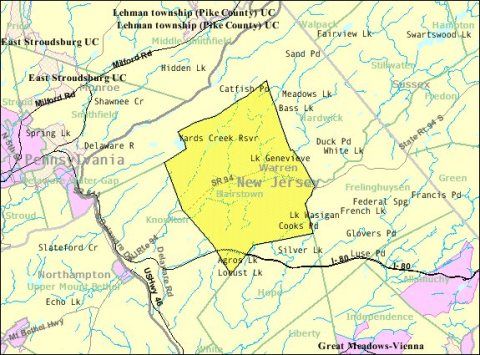
Blairstown is a township in Warren County, in the U.S. state of New Jersey. As of the 2020 United States census, the township's population was 5,704, a decrease of 263 (−4.4%) from the 2010 census count of 5,967, which in turn reflected an increase of 220 (+3.8%) from the 5,747 counted in the 2000 census. The area had been known as Smith's Mill and was later called Butts Bridge (variously spelled as "Butt's Bridge" and "Butts' Bridge"), named for a family that owned the eponymous crossing of the Paulins Kill. Blairstown was incorporated as a township by an act of the New Jersey Legislature on April 14, 1845, from portions of Knowlton Township, based on the results of a referendum held that …
Its first post office opened in 1839. Between the 2010 and 2020 censuses its population fell from 5,967 to 5,704 (-4%).
Intro from Wikipedia. Population: U.S. Census Bureau.
From the old history books
What they wrote about Blairstown Township in 1929
Passages that mention Blairstown Township, cut from the printed page as they were published.
History and directory of Warren County, New Jersey1929 · page 24Read the page →
Read the text
Knowlton Township is supposed to have derived its name from the prevalence of knolls and hills within its borders. It was set off from Oxford township in 1764, and originally included Blairstown Township which was taken from it in 1845, and a part of Hope, which was formed in 1839. Columbia is on the Delaware River at the mouth of the Paulins Kill, opposite Portland, Pennsylvania, with which it is connected by a wooden covered bridge, which has recently been purchased and opened as a free bridge, it having been a toll bridge since its construction by the Columbia & Delaware Bridge Company in 1869. It is seven hundred ninety-six feet long with four spans of
Text read by machine from the scan; it may contain errors.
Scans and text from the Internet Archive. Books published in 1930 or earlier, which are in the public domain.
Timeline
Blairstown Township, 1820 to 1998
Woven from the archive, old maps, post office records, the National Register and the people born here.
Nothing in the archives for these yearsWeddings on Main Street, storms, parades, school pictures, the old store. If it’s in your family album, it belongs here.
Every edition of the U.S. Geological Survey’s map of Blairstown Township. Tap a year, or press play to watch the town change.
1943Blairstown sheet · 1:31,680
U.S. Geological Survey historical topographic maps (public domain), via Esri’s collection of the scans. The red ring marks the center of Blairstown Township.
Then & now
Stand where they stood
No then-and-now pairs yet. Take a photo from the same spot as an old one and they appear here side by side.
Retake this view51746.LA#001--Plat showing land to be taken from Jacob Mingle heirs for road purposes--Blairstown, NJ [1909.12.01], 1909
Find the spot, match the angle, and add your photo. It becomes the first then-and-now pair on Blairstown Township’s page.
The Blairstown Township post office opened in 1839, the earliest record of the town by name (U.S. post office records). Wikidata gives 1845.
How does Blairstown Township rank for history?
Blairstown Township is more historic than 92% of U.S. towns, #45 of 468 in New Jersey. The History grade combines the town’s founding era, the share of homes built before 1940 and its National Register listings. It’s a character grade, so it isn’t part of the overall grade. How it works.
What is on the National Register in Blairstown Township?
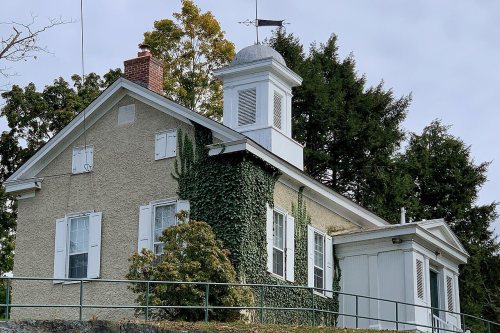
Two places: the Blair Presbyterial Academy (listed 1992) and the Blairstown Historic District (2007).
How old are the homes in Blairstown Township?
21% of Blairstown Township’s homes were built before 1940 (Census estimate, ±9.4 points), against a typical 15% for a New Jersey town; the median home was built in 1975.
Founding dates: Wikidata, Wikipedia, the U.S. post office records of Blevins & Helbock (CC0) and the Census. Homes by year built: Census ACS 2020–24. National Register of Historic Places: National Park Service (list of May 22, 2026). Old photos, postcards and papers: Wikimedia Commons, the Library of Congress and other public archives, credited on each item’s page. Maps: U.S. Geological Survey historical topographic maps (via Esri) and Sanborn fire-insurance maps (Library of Congress). History text and census tables: Wikipedia (CC BY-SA 4.0). Places that used to be: USGS Geographic Names Information System (2021).
From Wikimedia Commons (21), the Library of Congress (1), Wikidata (2), the National Register of Historic Places (2), U.S. Geological Survey historical maps, U.S. Census counts (via Wikipedia), the US Post Offices dataset (Blevins & Helbock), the USGS Geographic Names Information System and old county and town histories (Internet Archive). Archive images are copied here with their credits and licenses, shown on each photo’s page. Refreshed monthly.




 1914
 2026
 2026
 2026
 2026
 2026
 2026
 2025
 2014
 2014
 2011
 2011
 2008
 2008
 2007
 2007
 2007
 2005
 2005


