Founding year: Wikidata. First post office: 1815.The full story ↓
History grade
What drives Swanzey’s History grade
On its age, its old homes and the National Register, Swanzey is more historic than 87% of U.S. towns, #51 of 126 in New Hampshire. All 3 inputs are above most U.S. towns; its age ranks highest and its National Register listings lowest.
A
HistoryA character grade: shown, never part of Swanzey’s overall grade.
New Hampshire towns list more on the Register than most of the country (a typical New Hampshire town has 9.5 per 10,000 residents, the U.S. 2.4), so Swanzey’s 6.8 sits near the middle of its state (41% of New Hampshire towns have fewer) while its 5 listings outnumber those of 70% of U.S. towns.
NoteThe founding year comes from Wikidata alone; no second source gives 1753.
How sure. Graded on any two of the three inputs instead, the letter would range from B+ to A. The pre-1940 share is a Census survey estimate (±6.7 points).
Founding year: Wikidata (other dates in Quick answers). Homes: Census ACS 2020–24. National Register: National Park Service, May 2026 list; each listing counted once (boundary changes and added documentation belong to their listing), and a historic district counts its contributing buildings. How TownRatings grades history →
What stands out about Swanzey’s past
Read from the archive, the National Register and the record. The page puts what stands out first.
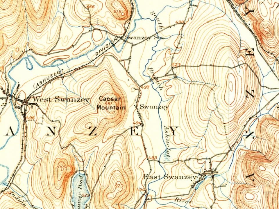
First granted in 1733 as "Lower Ashuelot", Swanzey was one of the fort towns established by Governor Jonathan Belcher of Massachusetts, which then claimed the territory. The town was the site of many battles during King George's War, and in 1747 it was abandoned for three years. It was regranted to 62 proprietors on July 2, 1753, by Governor Benning Wentworth as "Swanzey", most probably because some early settlers had a connection to Swansea in Wales. Situated on the Ashuelot River and connected by the Ashuelot Railroad, West Swanzey developed as a textile mill town, and East Swanzey produced wooden buckets for generations. By 1859, the population was 2,106.
Passages that mention Swanzey, cut from the printed page as they were published.
The history of Swanzey, New Hampshire, from 1734 to 18901892 · page 188Read the page →
Read the text
"To the inliabitants of the town of Swanzey. Gentlemen — We the subscribers, inhabitants of the town of Swanzey, not being conveniently situated to attend school at the school-house, and being anxiously concerned for the education of our children, humbly request the favor of being formed into a school district by ourselves, witli the liberty of building a school-house and appropriating our proportion of school money for the use and benefit of a school in said district.
Text read by machine from the scan; it may contain errors.
The history of Swanzey, New Hampshire, from 1734 to 18901892 · page 180Read the page →
Read the text
Viirious attempts have been made by the earl}'' itinerant to establish Methodist preaching in Swanzey, but all efforts proved unavailing. About 1840 efforts were again made to establish preaching at Swanzey Factory and East Swanzey with but little success, although a class was formed at the latter place and connected with the Keene charge.
Text read by machine from the scan; it may contain errors.
History of the town of Marlborough, Cheshire County, New Hampshire1881 · page 396Read the page →
Read the text
commenced practice in Wells, Me., where he remained two years, when he removecl to "Woburn, Mass. He practised medicine there six years, and then moved to Swanzey where he resided until 1872, when he came to Marlborough. He represented the town of Swanzey in the State Legislature one year, held the office of County Commissioner three years, and was Justice of the Peace fifteen years; also Post-master from the time Lincoln
Text read by machine from the scan; it may contain errors.
Scans and text from the Internet Archive. Books published in 1930 or earlier, which are in the public domain.
Timeline
Swanzey, 1753 to 1920
Woven from the archive, old maps, post office records, the National Register and the people born here.
In 1753, according to Wikidata. Swanzey’s post office opened in 1815, and the first U.S. census counted 1,157 people here in 1790.
How does Swanzey rank for history?
Swanzey is more historic than 87% of U.S. towns, #51 of 126 in New Hampshire. The History grade combines the town’s founding era, the share of homes built before 1940 and its National Register listings. It’s a character grade, so it isn’t part of the overall grade. How it works.
What is on the National Register in Swanzey?
5 listings: 1 building and 4 structures.
How old are the homes in Swanzey?
20% of Swanzey’s homes were built before 1940 (Census estimate, ±6.7 points), against a typical 17% for a New Hampshire town; the median home was built in 1978.
Founding dates: Wikidata, Wikipedia, the U.S. post office records of Blevins & Helbock (CC0) and the Census. Homes by year built: Census ACS 2020–24. National Register of Historic Places: National Park Service (list of May 22, 2026). Old photos, postcards and papers: Wikimedia Commons, the Library of Congress and other public archives, credited on each item’s page. Maps: U.S. Geological Survey historical topographic maps (via Esri) and Sanborn fire-insurance maps (Library of Congress). History text and census tables: Wikipedia (CC BY-SA 4.0). Places that used to be: USGS Geographic Names Information System (2021).
From Wikimedia Commons (20), the National Register of Historic Places (5), Wikipedia, Wikidata and Wikipedia for famous people, U.S. Geological Survey historical maps, U.S. Census counts (via Wikipedia), the US Post Offices dataset (Blevins & Helbock), the USGS Geographic Names Information System and old county and town histories (Internet Archive). Archive images are copied here with their credits and licenses, shown on each photo’s page. Refreshed monthly.




 Date?
 Date?
 2026
 2026
 2025
 2025
 2025
 2025
 2025
 2025
 2025
 2024
 2022
 2021
 2013
 2013
 2011
 2011
 2011
 2011


