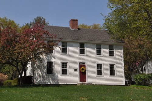
Surry was chartered in 1769, and named for Charles Howard, 10th Duke of Norfolk, and Earl of Surrey. The first census taken in Surry, in 1790, reported 448 residents.
Passages that mention Surry, cut from the printed page as they were published.
History of the town of Surry, Cheshire County, New Hampshire1925 · page 180Read the page →
Read the text
The earliest manuscript record of the church in town has probably been destroyed, but a later record, much worn and torn in places, gives all the needed facts. It begins thus : Surry, Dec. 18, 1793. At a meeting of the Church in Surry the subscribers being appointed a committee by vote of the Church to make inquiry with regard to the time when the church was first incorporated in Surry, the persons who subscribed the covenant, and collect all other matters, as far as may be.
Text read by machine from the scan; it may contain errors.
History of the town of Surry, Cheshire County, New Hampshire1925 · page 223Read the page →
Read the text
Walpole. The following petition, however, was by a vote of the town, granted on March 2, 1801: "The Petition of the Subscribers to the Legal Voters of the Town of Surry Humbly Shewith That as they Annually Pay their Proportion of School Taxes in said Town of Surry and that they are so situated that they are not conveaned by the school in their District, therefore they Pray that Said Town will set them off or grant them the privilege to pay their proportion of School Money to a Distinct in Walpole where
Text read by machine from the scan; it may contain errors.
Scans and text from the Internet Archive. Books published in 1930 or earlier, which are in the public domain.
By decade
Surry, decade by decade
One decade in the archive so far: the 1990s. Scroll each row; tap a photo for its story.
Founding dates: Wikidata, Wikipedia, the U.S. post office records of Blevins & Helbock (CC0) and the Census. Homes by year built: Census ACS 2020–24. National Register of Historic Places: National Park Service (list of May 22, 2026). Old photos, postcards and papers: Wikimedia Commons, the Library of Congress and other public archives, credited on each item’s page. Maps: U.S. Geological Survey historical topographic maps (via Esri) and Sanborn fire-insurance maps (Library of Congress). History text and census tables: Wikipedia (CC BY-SA 4.0). Places that used to be: USGS Geographic Names Information System (2021). How TownRatings grades history →
From Wikimedia Commons (5), Wikidata (1), the National Register of Historic Places (1), Wikipedia, the US Post Offices dataset (Blevins & Helbock), the USGS Geographic Names Information System and old county and town histories (Internet Archive). Archive images are copied here with their credits and licenses, shown on each photo’s page. Refreshed monthly.


 2017
 2016
 2016
 2016