21 of Wilmington’s places are on the National Register
More historic than 80% of U.S. towns · #48 of 290 in North Carolina. What drives it
Most of Wilmington was built recently: 9% of its homes predate 1940 and the median home dates from 1989. Below: 9 old photos and papers, maps from 1884 on, and the census since 1800.
On its age, its old homes and the National Register, Wilmington is more historic than 80% of U.S. towns, #48 of 290 in North Carolina. Its National Register listings hold the grade up; its share of homes from before 1940 pulls it down.
A−
HistoryA character grade: shown, never part of Wilmington’s overall grade.
Among the 400 U.S. cities of 100,000 or more, Wilmington ranks #119 on History.
North Carolina towns list more on the Register than most of the country (a typical North Carolina town has 12.5 per 10,000 residents, the U.S. 2.4), so Wilmington’s 259 sits above most of its state (88% of North Carolina towns have fewer) while its 3,129 historic buildings outnumber those of 100% of U.S. towns.
How sure. Graded on two of the three inputs, so a change in either one moves the letter more than it would with three. The pre-1940 share (±0.9 points) is firm at this size.
Founding year: our sources. Homes: Census ACS 2020–24. National Register: National Park Service, May 2026 list; each listing counted once (boundary changes and added documentation belong to their listing), and a historic district counts its contributing buildings. How TownRatings grades history →
What stands out about Wilmington’s past
Read from the archive, the National Register and the record. The page puts what stands out first.
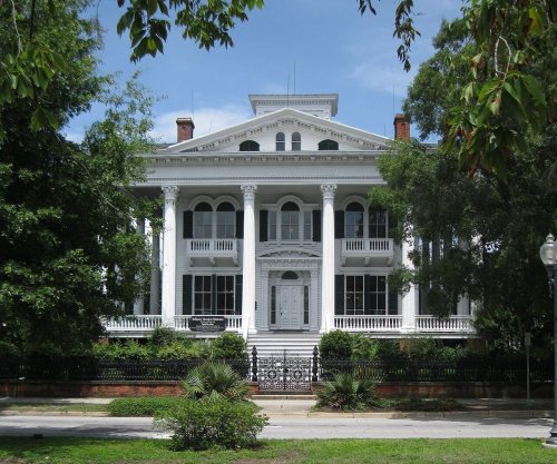
The country’s official list of buildings and places worth saving. One is a National Historic Landmark, the highest tier. Boundary changes and added documentation are counted with their listing.
National Park Service, National Register of Historic Places. Photos from Wikimedia Commons, credited on each place’s page.
Places that used to be
Lost post offices, old corners and burying grounds
Wilmington’s post office has been open since 1789. Four other post offices opened and closed inside today’s town.
Wilmington
1789–today
Wrightsvilie
1881–1909
Masonboro
1890–1891
Sea Gate
1910–1932
Wrightsville Sound
1923–1955
17801900today
Hamlets and corners on the map
AirlieAzalea Mobile Home ParkBarclay HillsBradley Creek East EstatesBradley Creek PointBradley ParkCamelot Mobile ParkCavalier WoodsCollege AcresColonial Village Mobile Home ParkD and H Estates Mobile Home ParkDelgadoDevon ParkDriftwood Mobile Home ParkEcho FarmsEdgewater EstatesFaircrest Mobile Home ParkFairlawnForest HillsGlen MeadeGrants Mobile Home ParkGreenville Village Mobile Home ParkHidden Lakes Mobile Home ParkHinsons Mobile Home Park
6cemeteries and burying grounds inside Wilmington
Calvary MemorialGreenlawn Memorial ParkOakdaleOleander Memorial GardensSaint James EpiscopalWilmington National
US Post Offices dataset (Blevins & Helbock, CC0). Places and cemeteries from the USGS Geographic Names Information System (2021).
The city was founded in the 1730s. After going through a series of different names (New Carthage, New London, Newton), its name became Wilmington. In 1739, Col. William Bartram, the uncle of the naturalist, introduced a bill to establish Wilmington, named for one of his patrons, Spencer Compton, Earl of Wilmington.
The area along the river had been inhabited by various successive cultures of indigenous peoples for thousands of years.
Passages that mention Wilmington, cut from the printed page as they were published.
Wilmington. Past, present & future, embracing historical sketches of its growth and progress from its establishment to the present time, together with outline of North Carolina history. Also a review of its manufacturing, mercantile, naval, and general bu1884 · page 16Read the page →
Read the text
J3uring the Revolution, the town of Wilmington became a place of much miUtary importance. The most important event of this period, perhaps, as regards the town of Wilmington, was the battle of Moore's Creek, which occurred about eighteen miles from the city, where the county bridge now crosses that stream. It was fought on the 27th of February, 1776, between the Scotch Tories, under Brigadier General McDonald, and a small body of patriot Whigs, under Colonels Caswell and Lillington. The Tories were on their way to Wilmington to effect a junction with Sir Peter Parker and Major- General Sir Henry CUnton, who arrived in Cape Fear with a military and naval arma-
Text read by machine from the scan; it may contain errors.
Wilmington. Past, present & future, embracing historical sketches of its growth and progress from its establishment to the present time, together with outline of North Carolina history. Also a review of its manufacturing, mercantile, naval, and general bu1884 · page 53Read the page →
Read the text
The Commissioners of Navigation and Pilotage for the Cape Fear River and Bars were formerly elected by the qualified voters of the City of Wilmington, but in 1870 the Leglislature of the State passed an act authorizing and requiring the Mayor and Aldermen of the City of Wilmington to appoint every year five persons, and the Mayor and Commissioners of the town of Smithville two persons, to serve as Commissioners of Navigation and Pilotage for the Cape Fear River and Bars, and providing that the seven persons so appointed should have power to do and perform all acts therefore authorized by law to be done by the Board of Commissioners of Navigation and
Text read by machine from the scan; it may contain errors.
Haddock's Wilmington, N.C., directory, and general advertiser1871 · page 22Read the page →
Read the text
In all, Wilmington can boast of three lines of railway now in actual operation, afrgregating a distance of four hundred and forty-five miles, over which the ii-on horse speeds daily, bringing in to us the rich supplies of the interior. Of these the Wilmington & Weldon, one hundred and sixty-two miles in length, stretches along the entire seaboard route from Wilmington to Weldon ; the Wilmington, Columbia & Augusta (form - 'Srly the Wilmington & Manchester) pierces one of the richest agricultural sections of South Carolina, one hundred and seventy-one miles
Text read by machine from the scan; it may contain errors.
Scans and text from the Internet Archive. Books published in 1930 or earlier, which are in the public domain.
Timeline
Wilmington, 1789 to 1986
Woven from the archive, old maps, post office records, the National Register and the people born here.
Nothing in the archives for these yearsWeddings on Main Street, storms, parades, school pictures, the old store. If it’s in your family album, it belongs here.
Every edition of the U.S. Geological Survey’s map of Wilmington. Tap a year, or press play to watch the town change.
1942Wilmington sheet · 1:62,500
U.S. Geological Survey historical topographic maps (public domain), via Esri’s collection of the scans. The red ring marks the center of Wilmington.
Every building
Wilmington, building by building, 1884–1915
Fire insurance maps drew every building, what it was made of and what it was used for, so insurers could price the risk of fire. Pick a year, then a sheet.
Wilmington is more historic than 80% of U.S. towns, #48 of 290 in North Carolina. The History grade combines the town’s founding era, the share of homes built before 1940 and its National Register listings. It’s a character grade, so it isn’t part of the overall grade. How it works.
What is on the National Register in Wilmington?
21 listings: 8 buildings, among them the City Hall/Thalian Hall (listed 1970, the first), 9 historic districts with 3,115 contributing buildings, 1 site, and 3 structures. 3,129 historic buildings in all.
How old are the homes in Wilmington?
9% of Wilmington’s homes were built before 1940 (Census estimate), against a typical 4.1% for a North Carolina town; the median home was built in 1989.
Founding dates: Wikidata, Wikipedia, the U.S. post office records of Blevins & Helbock (CC0) and the Census. Homes by year built: Census ACS 2020–24. National Register of Historic Places: National Park Service (list of May 22, 2026). Old photos, postcards and papers: Wikimedia Commons, the Library of Congress and other public archives, credited on each item’s page. Maps: U.S. Geological Survey historical topographic maps (via Esri) and Sanborn fire-insurance maps (Library of Congress). History text and census tables: Wikipedia (CC BY-SA 4.0). Places that used to be: USGS Geographic Names Information System (2021).
From Wikimedia Commons (9), Wikidata (2), the National Register of Historic Places (21), Wikipedia, Wikidata and Wikipedia for famous people, U.S. Geological Survey historical maps, U.S. Census counts (via Wikipedia), the US Post Offices dataset (Blevins & Helbock), the USGS Geographic Names Information System, Sanborn fire insurance maps (Library of Congress) and old county and town histories (Internet Archive). Archive images are copied here with their credits and licenses, shown on each photo’s page. Refreshed monthly.


 ★ Landmark




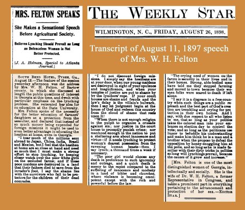


 1898
 1898
 1898
 1898
 1898


