Guest, Sign inJoin

Post to Lee's Summit

We’ll email a one-tap link to publish your post. No password, and nothing is public until you click it.
Already a member? Sign in
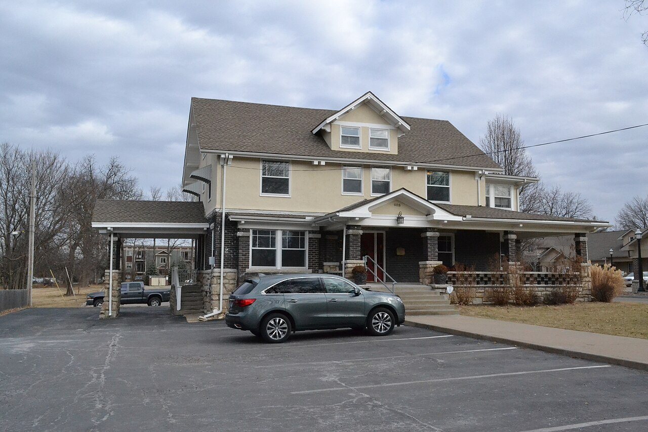
Todd M. Sr. George HouseTodd M. Sr. George House · Photo: 25or6to4 · CC BY-SA 4.0
A−Outdoors
Outdoors in Lee's Summit

11% of Lee's Summit’s land is conserved: 4,351 acres

The biggest trail networks: Longview Lake Park (10.5 mi), Legacy Park (6.7 mi), Fleming Park (3.8 mi). 3,207 acres are parks and preserves, 31 per 1,000 residents. 38 miles of mapped trail cross Lee's Summit, 0.6 per square mile of land.

Ahead of 82% of U.S. towns · #16 of 247 in Missouri. What drives it

Conserved land
11%
4,351 acres · of 63.9 sq mi of land
Trails
38 mi
0.6 per sq mi of land
Park land
3,207 ac
31 acres per 1,000 residents
Near a park
79%
of residents within ½ mile
Bike routes
63 mi
8.0 mi lanes · 55 mi paths
Highest peak
1,083 ft
Bowler Hill
Lakes & rivers
12
2 beaches · 6 boat launches

What kind of outdoors town is Lee's Summit?

Read from the map. The page puts what stands out first.

Outdoors grade

How much outdoors does Lee's Summit have?

On conserved land, trails, park land and how close residents live to a park, Lee's Summit is ahead of 82% of U.S. towns, #16 of 247 in Missouri. All four inputs are above most U.S. towns; conserved land ranks highest, the share of residents near a park lowest.

A−
OutdoorsA character grade: shown, never part of Lee's Summit’s overall grade.
All U.S. towns we grade (21,298)Ahead of 82%
LessMore
Missouri towns of 2,500+ (247)Ahead of 94%

Among the 400 U.S. cities of 100,000 or more, Lee's Summit ranks #178 on Outdoors.

Few Missouri towns conserve much land (a typical one, 2%; the U.S., 4%), so Lee's Summit’s 11% is ahead of 96% of Missouri towns, while its trails per square mile lead 73% of them.

How sure. Graded on any three of the four inputs instead, the letter would still be A−. Trails and many small parks come from OpenStreetMap, mapped by volunteers, so coverage varies from town to town; the half mile is a straight line from each census block, so a river or highway in the way isn’t counted against it.

PAD-US, OpenStreetMap (© OpenStreetMap contributors), Census 2025 Gazetteer and 2020 blocks; details in Sources below. How TownRatings grades the outdoors →

The map

Conserved land, trails & bike routes

Tap a number to zoom to a park. Tap a layer to hide it.

12345678
Easements protect land from building but are usually private.© OpenStreetMap contributors · USGS PAD-US
Places to walk

Pick a walk

The longest trail network is Longview Lake Park, with 10.5 miles. Directions go to the nearest trailhead or public parking.

Longview Lake Park

Park
1,403 acres10.5 mi of trail
Longview Lake Horse TrailLongview Equestrian TrailLongview Lake Horse Trail - Lasso LoopLongview Lake Horse Trail - Big Cedar Loop
Dog rules not recorded
Directionsto the parking lot

Legacy Park

Park
680 acres6.7 mi of trail
1014 Loop
Dogs on leash
Directionsto the trailhead

Fleming Park

Managed by Jackson County Parks and Recreation
1,788 acres3.8 mi of trail
North Shore Trail
Dogs on leash
Directionsto the trailhead

Velie Park

Park
31 acres1.2 mi of trail
Dog rules not recorded
Directionsto the parking lot

Lowenstein Park

Managed by Lee's Summit Parks and Recreation
18 acres1.1 mi of trail
Dog rules not recorded
Directionsto the parking lotWebsite ↗

Charles David Hartman Park

Managed by City of Lee's Summit
19 acres1 mi of trail
Dog rules not recorded
Directionsto the parking lot

Miller J Fields Park

Park
18 acres0.8 mi of trail
Dog rules not recorded
Directionsto the parking lot

Lea McKeighan South Park

Park
11 acres0.8 mi of trail
Dog rules not recorded
Directionsto the parking lot
All 44 parks & preserves
Longview Lake Park1,403 acres · 10.5 mi of trail
Directions
Legacy Park680 acres · 6.7 mi of trail
Directions
Fleming Park1,788 acres · 3.8 mi of trail · Jackson County Parks and Recreation
Directions
Velie Park31 acres · 1.2 mi of trail
Directions
Lowenstein Park18 acres · 1.1 mi of trail · Lee's Summit Parks and Recreation
Directions
Charles David Hartman Park19 acres · 1 mi of trail · City of Lee's Summit
Directions
Miller J Fields Park18 acres · 0.8 mi of trail
Directions
Lea McKeighan South Park11 acres · 0.8 mi of trail
Directions
Osage Trails Park20 acres · 0.7 mi of trail · Lee's Summit Parks and Recreation
Howard Park21 acres · 0.6 mi of trail
Directions
Winterset Park Nature Area12 acres · 0.6 mi of trail · City of Lee's Summit
Directions
Lea McKeighan North Park10 acres · 0.5 mi of trail
Directions
Summit Park9 acres · 0.4 mi of trail
Directions
North Prairie Lee Park37 acres · 0.3 mi of trail · Jackson County Parks + Rec
Directions
Canterbury Park6 acres · 0.3 mi of trail
Peale Park4 acres · 0.3 mi of trail
Deer Valley Park23 acres · 0.2 mi of trail · Lee's Summit Parks and Recreation
Directions
Monarch View Community Space8 acres · 0.2 mi of trail
Harris Memorial Park7 acres · 0.2 mi of trail
Oak Tree Park3 acres · 0.2 mi of trail
Longview Lake County Park11 acres · 0.1 mi of trail
Directions
Happy Tails Park5 acres · 0.1 mi of trail · Lee's Summit Parks and Recreation
Directions
Green Street5 acres · 0.1 mi of trail
Directions
Williams-Grant Park3 acres · 0.1 mi of trail
Directions
Park Ridge Community Park1 acres · 0.1 mi of trail
South Prairie Lee Park128 acres · Jackson County Parks + Rec
Directions
Little Blue Trace Nature Preserve126 acres · Jackson County Parks + Rec
Directions
Eagle Creek Park26 acres · Lee's Summit Parks & Recreation
Banner Park20 acres
Arborwalk Park20 acres · Lee's Summit Parks and Recreation
McKee Park18 acres · Lee's Summit Parks and Recreation
Directions
Pleasant Lea Park17 acres
Bryan C Pottberg Park11 acres
Directions
Longview Barns Historical Park9 acres
Lakewood Development Park7 acres
Directions
Langford Plaza Park5 acres
Summit Crossing Loop Park4 acres
Newberry HOA Common Area4 acres · Newberry Home Owners Association
James A. Reed Wildlife Area3 acres · Missouri Department of Conservation
Wadsworth Park2 acres
Bridgehampton Park1 acres
Directions
William B. Howard Station Park1 acres
Directions
South Lea Park1 acres · City of Lee's Summit
Langsford Park1 acres
Who protects it

4,351 conserved acres

11% of Lee's Summit’s land. Who manages Lee's Summit’s conserved land, from the USGS Protected Areas Database. Approximate, because parcels can overlap.

County1,795 ac
Army Corps of Engineers1,393 ac
Town or city1,144 ac
Land trusts & nonprofits17 ac
Not recorded2 ac
Local Park · 2,911 acRecreation Management Area · 1,393 acLocal Recreation Area · 18 acConservation Easement · 17 acLocal Conservation Area · 10 ac
Good to know

Conserved doesn’t always mean open to visitors. 17 acres are conservation easements, usually private land. The walks above are places people visit.

The biggest protected parcels
Parcel (PAD-US)Managed byAcresPublic access
Fleming Park
Local Park
County1,794Open
Longview Recreation Area
Recreation Management Area
Army Corps of Engineers1,393Open
Legacy
Local Park
Town or city687Open
Park West
Local Park
Town or city49Open
Bailey Farm
Local Park
Town or city48Open
Velie
Local Park
Town or city32Open
Eagle Creek
Local Park
Town or city27Open
Deer Valley
Local Park
Town or city24Open
Howard
Local Park
Town or city22Open
Lea Mckeighan
Local Park
Town or city22Open

5 smaller protected places aren’t shown.

Things to do

116 places to go in Lee's Summit

Beaches, playgrounds, peaks, falls and more. Pick a kind.

Playgrounds in Lee's Summit
Harris ParkIn Harris Memorial Park
Directions
Howard Park Play GroundIn Howard Park
Directions
Joseph A. Dyke PlagroundIn Legacy Park
Directions
Playground in the Legacy Soccer complexIn Legacy Park
Directions
Pleasant Lea ParkIn Pleasant Lea Park
Directions
Shelter 10 playgroundIn Fleming Park
Directions
Shelter 6 PlaygroundIn Fleming Park
Directions
Shelter 7 PlaygroundIn Fleming Park
Directions
5 more playgrounds
Shelter 7 SwingsetIn Fleming Park
Directions
Shelter 8 PlaygroundIn Fleming Park
Directions
Shelter 9 swingsetIn Fleming Park
Directions
Woods Playground
Directions
shelter 9 playgroundIn Fleming Park
Directions

96 playgrounds are on OpenStreetMap in all; the list shows named ones from the first 30.

Trails & water

6 named trails and 12 lakes & rivers

Named trails
Open to bikes · 3.1 miHorses · 10.6 miUnpaved · 14.9 mi
Longview Lake Horse Trail5.9 mi
1014 Loop2.7 mi
Longview Equestrian Trail2.2 mi
Longview Lake Horse Trail - Lasso Loop0.4 mi
Longview Lake Horse Trail - Big Cedar Loop0.2 mi
North Shore Trail0.1 mi
Lakes & rivers tap for directions
Biking & sports

63 miles of bike routes

Bike lanes are often missing from the map in smaller towns, so that number is likely low.

8.0 mi
painted or protected bike lanes
55 mi
off-road bike paths
Courts & fields
74Baseball
45Tennis
41Soccer
15Football
14Basketball
10Softball
7Tracks
4Beach volleyball

Includes school and college facilities, which aren’t always open to the public.

History along the way

20 places on the National Register

The country’s official list of places worth saving (National Park Service). The map also marks 2 historic points from OpenStreetMap: plaques, memorials and old buildings.

History →
Saint Paul's Episcopal ChurchBuilding · listed 1985
About it
Longview FarmBuilding · listed 1985
About it
Lee's Summit Downtown Historic DistrictDistrict · listed 2005
About it
Bailey Family Farm Historic DistrictDistrict · listed 2006
About it
Howard Neighborhood Historic DistrictDistrict · listed 2007
About it
Northeast Douglas Street Residential Historic DistrictDistrict · listed 2008
About it
Northeast Forest Avenue and Northeast Green Street Residential Historic DistrictDistrict · listed 2008
About it
Northeast Green and 1st Streets Residential Historic DistrictDistrict · listed 2008
About it
Todd M. Sr. George HouseBuilding · listed 2010
About it
Southeast Green Street Historic Cottage DistrictDistrict · listed 2010
About it
Southeast Third Street Residential Historic DistrictDistrict · listed 2010
About it
Sherwood Manufacturing Company BuildingBuilding · listed 2010
About it

8 more on the History page.

When to get out

April is the best month for walking in Lee's Summit

NOAA’s 1991–2020 normals for the town and the daylight at its latitude. Outlined months have long days, highs of 59 to 86 °F and little rain for the place.

JanFebMarAprMayJunJulAugSepOctNovDec
Daylight (h)9.710.711.813.214.314.914.613.712.411.110.09.4
High (°F)394456667584888779675443
Rain (in)1.31.72.64.35.75.24.84.24.13.42.31.8

January is the driest month (1.3 in) and July the warmest (highs of 88 °F). 5.7 inches fall in May, the wettest month. Summer highs reach 88 °F, too hot for the outline. The climate in Lee's Summit →

Next door

Lee's Summit and its neighbors

Tap a town to see its outdoors.

TownConserved
of land
Trail mi
per sq mi
Park acres
per 1,000
Near a park
½ mile
Outdoors
Lee's Summit11%0.63179%A−
Independence5%0.61974%B+
Kansas City7%0.62589%A−
Unity Village— not graded: under 1,000 residents or part of its town
Greenwood24%1.5691%A−
Lake Lotawanaunder 1%under 0.1333%D

The four inputs of the Outdoors grade, from the engine; shares are of land, not water.

Questions about parks and trails in Lee's Summit

Where can I hike in Lee's Summit?

The longest trail networks: Longview Lake Park, 10.5 miles; Legacy Park, 6.7 miles; Fleming Park, 3.8 miles; Velie Park, 1.2 miles. Each one is on the map above, with directions to the nearest trailhead or parking.

How much of Lee's Summit is conserved land?

11% of its land, against a typical 2% for a Missouri town and 4% nationally (PAD-US). Conserved doesn’t always mean open to visitors: easements are usually private land.

Are dogs allowed on Lee's Summit’s trails?

OpenStreetMap records dogs as welcome at Legacy Park (on leash) and Fleming Park (on leash). For the rest, check the signs at the trailhead.

Where can I bike in Lee's Summit?

63 miles of bike routes are on the map: 8.0 of painted or protected lanes and 55 of off-road paths.

Is there public land near Lee's Summit?

28,267 acres of parks and open public land lie inside Lee's Summit or within 10 miles of it (PAD-US), 4,325 of them inside the city line.

How much outdoors does Lee's Summit have?

Ahead of 82% of U.S. towns on the Outdoors grade, #16 of 247 in Missouri. The grade combines the share of land that is conserved, miles of mapped trail per square mile of land, park acres per 1,000 residents and the share of residents within a half mile of a park. It’s a character grade, so it isn’t part of the overall grade. How it works.

Trail talk

Conditions, parking and favorite walks from Lee's Summit neighbors.
Town Square →
Share a tip
Sources

Where this page comes from

Conserved and public land: USGS Protected Areas Database of the United States (PAD-US), service updated July 2026. Parks, trails, playgrounds, beaches and other places: OpenStreetMap (© OpenStreetMap contributors, ODbL), map data as of 2026-10-28. Land and water area: Census 2025 Gazetteer. Residents near a park: 2020 Census blocks. National Register: National Park Service. How TownRatings grades the outdoors →