Mankato dates to 1852, and 15% of its homes were built before 1940
More historic than 73% of U.S. towns · #41 of 273 in Minnesota. What drives it
14 places in town are on the National Register, among them two historic districts with 262 buildings between them. Below: 6 old photos and papers, maps from 1884 on, and the census since 1870.
Founding year: Wikidata. First post office: 1853.The full story ↓
History grade
What drives Mankato’s History grade
On its age, its old homes and the National Register, Mankato is more historic than 73% of U.S. towns, #41 of 273 in Minnesota. Its National Register listings hold the grade up; its age pulls it down.
B+
HistoryA character grade: shown, never part of Mankato’s overall grade.
Minnesota towns list about as much on the Register as the country (a typical Minnesota town has 2.1 per 10,000 residents, the U.S. 2.4), so Mankato’s 60.5 sits above most of its state (95% of Minnesota towns have fewer) while its 275 historic buildings outnumber those of 95% of U.S. towns.
How sure. Graded on any two of the three inputs instead, the letter would range from C+ to A. The pre-1940 share (±1.8 points) is firm at this size. Two sources give 1852.
Founding year: Wikidata (other dates in Quick answers). Homes: Census ACS 2020–24. National Register: National Park Service, May 2026 list; each listing counted once (boundary changes and added documentation belong to their listing), and a historic district counts its contributing buildings. How TownRatings grades history →
What stands out about Mankato’s past
Read from the archive, the National Register and the record. The page puts what stands out first.
National Park Service, National Register of Historic Places. Photos from Wikimedia Commons, credited on each place’s page.
Places that used to be
Lost post offices, old corners and burying grounds
Mankato’s post office has been open since 1853. Another post office, Hope, opened and closed inside today’s town.
Mankato
1853–today
Hope
1874–1896
18501940today
Hamlets and corners on the map
Belle HavenBenningEastwood Manor Mobile Home ParkHigh Ciara Mobile Home ParkKnollwood ParkLime Valley Mobile Home ParkSouthhaven Mobile Home ParkUniversity Park of Mankato
US Post Offices dataset (Blevins & Helbock, CC0). Places and cemeteries from the USGS Geographic Names Information System (2021).
Every building
Mankato, building by building, 1884–1914
Fire insurance maps drew every building, what it was made of and what it was used for, so insurers could price the risk of fire. Pick a year, then a sheet.
Mankato Township was not settled by European Americans until Parsons King Johnson in February 1852, as part of the 19th-century migration of people from the east across the Midwest. New residents organized the city of Mankato on May 11, 1858, the day Minnesota became a state. The city was organized by Johnson, Henry Jackson, Daniel A. Robertson, Justus C. Ramsey, and others.
Passages that mention Mankato, cut from the printed page as they were published.
History of Blue Earth County and biographies of its leading citizens1901 · page 467Read the page →
Read the text
LAMM, LEO S. — Numerous enterprises connected with the commercial development of Mankato have enlisted the means and co-operation of Leo S. Lamm, whose association with the progress of the city includes service as treasurer of the Mankato Savings and Building Association, treasurer of the Standard Brewing Company, (incorporated), vice-president of the First
Text read by machine from the scan; it may contain errors.
History of Blue Earth County and biographies of its leading citizens1901 · page 108Read the page →
Read the text
The middle of April 1863 saw in every river a tremendous flood, and the bridges all over the county were swept away. The government bridge over the Blue Earth at Mankato was among the rest, and no bridge was left on this river in the county. The bridges on the Watonwan suffered nearly as bad. The bridge over the Le Sueur on the Agency road, which Mr. Mc-
Text read by machine from the scan; it may contain errors.
Scans and text from the Internet Archive. Books published in 1930 or earlier, which are in the public domain.
Timeline
Mankato, 1850 to 1990
Woven from the archive, old maps, post office records, the National Register and the people born here.
In 1852, according to Wikidata. Mankato’s post office opened in 1853, and the census of 1870 counted 3,482 people here.
How does Mankato rank for history?
Mankato is more historic than 73% of U.S. towns, #41 of 273 in Minnesota. The History grade combines the town’s founding era, the share of homes built before 1940 and its National Register listings. It’s a character grade, so it isn’t part of the overall grade. How it works.
What is on the National Register in Mankato?
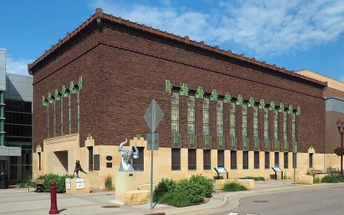
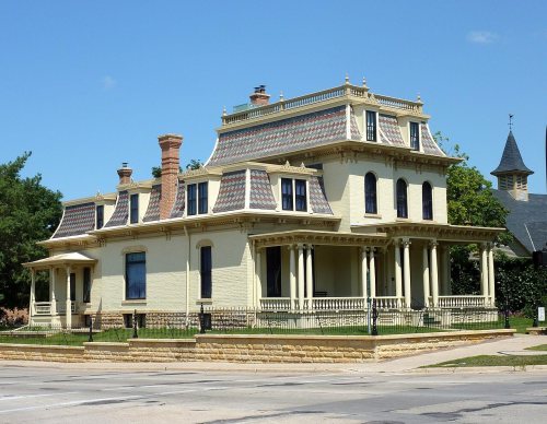
14 listings: 12 buildings, among them the First National Bank of Mankato (listed 1974, the first), and 2 historic districts, the Lincoln Park Residential Historic District and the North Front Street Commercial District, with 262 contributing buildings. 275 historic buildings in all.
How old are the homes in Mankato?
15% of Mankato’s homes were built before 1940 (Census estimate, ±1.8 points), against a typical 8.1% for a Minnesota town; the median home was built in 1982.
Founding dates: Wikidata, Wikipedia, the U.S. post office records of Blevins & Helbock (CC0) and the Census. Homes by year built: Census ACS 2020–24. National Register of Historic Places: National Park Service (list of May 22, 2026). Old photos, postcards and papers: Wikimedia Commons, the Library of Congress and other public archives, credited on each item’s page. Maps: U.S. Geological Survey historical topographic maps (via Esri) and Sanborn fire-insurance maps (Library of Congress). History text and census tables: Wikipedia (CC BY-SA 4.0). Places that used to be: USGS Geographic Names Information System (2021).
From Wikimedia Commons (6), the National Register of Historic Places (14), Wikipedia, Wikidata and Wikipedia for famous people, U.S. Census counts (via Wikipedia), the US Post Offices dataset (Blevins & Helbock), the USGS Geographic Names Information System, Sanborn fire insurance maps (Library of Congress) and old county and town histories (Internet Archive). Archive images are copied here with their credits and licenses, shown on each photo’s page. Refreshed monthly.




 1850
 1865
 1871
