Guest, Sign inJoin

Post to Inver Grove Heights

We’ll email a one-tap link to publish your post. No password, and nothing is public until you click it.
Already a member? Sign in
CHistory
History · Inver Grove Heights

Inver Grove Heights dates to 1852, and 1 of its places is on the National Register

More historic than 26% of U.S. towns · #186 of 273 in Minnesota. What drives it

Most of Inver Grove Heights was built recently: 2% of its homes predate 1940 and the median home dates from 1990. Its Register listing is the Reuben Freeman House. Below: 3 old photos and papers, maps from 1896 on, and the census since 1860.

1852founded
1on the National Register
2%homes built before 1940
3old photos & papers
3famous people
From Inver Grove Heights’ archive · credits on each photo
Quick answers

How Inver Grove Heights began

When was Inver Grove Heights founded?

1852

Inver Grove Heights dates its founding to 1852 (Wikidata). The census first counted it in 1860.

First census: 646 in 18602020 census: 35,801174 years

How historic is Inver Grove Heights?

C

More historic than 26% of U.S. towns, on its age, its old homes and the National Register.

What drives the grade ↓
Founding year: Wikidata. First post office: 1852.The full story ↓
History grade

What drives Inver Grove Heights’ History grade

On its age, its old homes and the National Register, Inver Grove Heights is more historic than 26% of U.S. towns, #186 of 273 in Minnesota. Its National Register listings hold the grade up; its share of homes from before 1940 pulls it down.

C
HistoryA character grade: shown, never part of Inver Grove Heights’ overall grade.
All U.S. towns we grade (21,289)Ahead of 26%
NewerOlder
Minnesota towns of 2,500+ (273)Ahead of 32%

Minnesota towns list about as much on the Register as the country (a typical Minnesota town has 2.1 per 10,000 residents, the U.S. 2.4), so Inver Grove Heights’ 0.3 sits near the middle of its state (48% of Minnesota towns have fewer) while its 1 listings outnumber those of 51% of U.S. towns.

NoteThe founding year comes from Wikidata alone; no second source gives 1852.
How sure. Graded on any two of the three inputs instead, the letter would range from C− to C. The pre-1940 share (±0.7 points) is firm at this size.

Founding year: Wikidata (other dates in Quick answers). Homes: Census ACS 2020–24. National Register: National Park Service, May 2026 list; each listing counted once (boundary changes and added documentation belong to their listing), and a historic district counts its contributing buildings. How TownRatings grades history →

What stands out about Inver Grove Heights’ past

Read from the archive, the National Register and the record. The page puts what stands out first.

★ What stands out · Places that used to be

Lost post offices, old corners, places now gone and burying grounds

Five other post offices opened and closed inside today’s town.

Carlisle
1852–1854
Pine Bend
1854–1854
Centralia
1856–1857
Pine Bend
1857–1904
Inver Grove
1886–1965
18501940today
Hamlets and corners on the map
Pine BendRoseportWescott
Gone or out of use
Pine Bend Post Officepost office
5cemeteries and burying grounds inside Inver Grove Heights
Old Emanuel Lutheran ChurchSaint PatrickSalem Evangelical KircheSalem United Methodist ChurchUnion

US Post Offices dataset (Blevins & Helbock, CC0). Places and cemeteries from the USGS Geographic Names Information System (2021).

Help out

Start Inver Grove Heights’s collection

The first neighbors to add old photos shape how Inver Grove Heights’s history is told.

Decades since 1900 with photos
00s10s20s30s40s50s60s70s80s90s
0 of 10 decades. The empty ones are waiting for someone’s album.
On the map

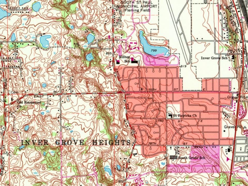
Inver Grove Heights on the map, 1896 to 1993

Every edition of the U.S. Geological Survey’s map of Inver Grove Heights. Tap a year, or press play to watch the town change.

Inver Grove Heights on the 1896 USGS mapInver Grove Heights on the 1951 USGS mapInver Grove Heights on the 1967 USGS mapInver Grove Heights on the 1972 USGS mapInver Grove Heights on the 1993 USGS map1896St Paul sheet · 1:62,500

U.S. Geological Survey historical topographic maps (public domain), via Esri’s collection of the scans. The red ring marks the center of Inver Grove Heights.

The story

How Inver Grove Heights came to be

From Wikipedia’s history of Inver Grove Heights.

Read it all →

After the signing of the Treaty of Traverse des Sioux in 1851, settlers from Ireland and Germany quickly staked claims in the rolling countryside west of the Mississippi River. Those of Irish descent farmed the eastern part of the community, while Germans cleared the wooded land to the west for their farms. French and English settlers built their homes along the river. The township of Inver Grove Heights was named after the Irish fishing village of Inver and the German town of Grove. Records show that 240 farms, four churches, and four school districts were founded by 1880. On March 9, 1965, the village of Inver Grove and Inver Grove Township merged to form Inver Grove Heights.

Text from Wikipedia, licensed CC BY-SA 4.0.

Timeline

Inver Grove Heights, 1852 to 2001

Woven from the archive, old maps, post office records, the National Register and the people born here.

  1. 19th century
  2. 1852
    FoundingInver Grove Heights is established
  3. 1852Post officeThe Carlisle post office opens
  4. 1854Post officeThe Carlisle post office closes
  5. 1854Post officeThe Pine Bend post office opens
  6. 1854Post officeThe Pine Bend post office closes
  7. 1856Post officeThe Centralia post office opens
  8. 1857Post officeThe Centralia post office closes
  9. 1874In the archiveInver Grove Heights in 1874
  10. 1896On the mapFirst mapped by the U.S. Geological Survey
  11. 20th century
  12. 1987Born hereHeather Kampf is born here
  13. 1997Born hereMichael Busch is born here
  14. 21st century
  15. 2001Born hereGreg Kerkvliet is born here
By decade

Inver Grove Heights, decade by decade

One decade in the archive so far: the 1870s. Scroll each row; tap a photo for its story.

Then & now

Stand where they stood

No then-and-now pairs yet. Take a photo from the same spot as an old one and they appear here side by side.

Inver Grove Heights in 1874
Retake this viewInver Grove Heights in 1874, 1874

Find the spot, match the angle, and add your photo. It becomes the first then-and-now pair on Inver Grove Heights’ page.

Retake this view · +15
On the National Register

1 historic place in Inver Grove Heights

The country’s official list of buildings and places worth saving.

place listed
1
National Historic Landmarks
0
none yet
historic buildings protected
1
each building in a district counts
first listed
1979
Reuben Freeman House
Buildings

Architectural styles listings

Vernacular1

National Park Service, National Register of Historic Places. Photos from Wikimedia Commons, credited on each place’s page.

People over time

Inver Grove Heights, census by census

05,00010,00015,00020,00025,00030,00035,00040,00019001950200035,801

Grew from 646 people in 1860 to 35,801 in 2020, more than tenfold.

17 censuses, 1860–2020.

U.S. Census Bureau decennial counts, from the census table on Inver Grove Heights’ Wikipedia page.

Famous people

3 famous people were born in Inver Grove Heights

Writers, athletes, leaders and more, ranked by how widely they’re known.

See all →
Stories next door

History across the town line

Each neighbor’s History grade, on the same three inputs.

Questions about Inver Grove Heights’ history

What year was Inver Grove Heights founded?

In 1852, according to Wikidata. Inver Grove Heights’ post office opened in 1852, and the census of 1860 counted 646 people here.

How does Inver Grove Heights rank for history?

Inver Grove Heights is more historic than 26% of U.S. towns, #186 of 273 in Minnesota. The History grade combines the town’s founding era, the share of homes built before 1940 and its National Register listings. It’s a character grade, so it isn’t part of the overall grade. How it works.

What is on the National Register in Inver Grove Heights?

One place: the Reuben Freeman House (listed 1979).

How old are the homes in Inver Grove Heights?

2% of Inver Grove Heights’ homes were built before 1940 (Census estimate), against a typical 8.1% for a Minnesota town; the median home was built in 1990.

Memory lane

What the archives can’t tell you, neighbors can.

Town Square →
Start a conversation
Sources

Where this page comes from

Founding dates: Wikidata, Wikipedia, the U.S. post office records of Blevins & Helbock (CC0) and the Census. Homes by year built: Census ACS 2020–24. National Register of Historic Places: National Park Service (list of May 22, 2026). Old photos, postcards and papers: Wikimedia Commons, the Library of Congress and other public archives, credited on each item’s page. Maps: U.S. Geological Survey historical topographic maps (via Esri) and Sanborn fire-insurance maps (Library of Congress). History text and census tables: Wikipedia (CC BY-SA 4.0). Places that used to be: USGS Geographic Names Information System (2021).

From Wikimedia Commons (6), the National Register of Historic Places (1), Wikipedia, Wikidata and Wikipedia for famous people, U.S. Geological Survey historical maps, U.S. Census counts (via Wikipedia), the US Post Offices dataset (Blevins & Helbock) and the USGS Geographic Names Information System. Archive images are copied here with their credits and licenses, shown on each photo’s page. Refreshed monthly.