Founding year: Wikidata; Wikipedia’s history section gives the same year. First post office: 1878.The full story ↓
History grade
What drives Warren’s History grade
On its age, its old homes and the National Register, Warren is more historic than 70% of U.S. towns, #101 of 143 in Maine. Its age holds the grade up; its National Register listings pull it down.
B+
HistoryA character grade: shown, never part of Warren’s overall grade.
Maine towns list more on the Register than most of the country (a typical Maine town has 15.9 per 10,000 residents, the U.S. 2.4), so Warren’s 0.0 sits below most of its state (10% of Maine towns have fewer) while its 0 listings outnumber those of 23% of U.S. towns.
How sure. Graded on any two of the three inputs instead, the letter would range from C+ to A. The pre-1940 share is a Census survey estimate (±7.8 points). Two sources give 1736.
Founding year: Wikidata (other dates in Quick answers). Homes: Census ACS 2020–24. National Register: National Park Service, May 2026 list; each listing counted once (boundary changes and added documentation belong to their listing), and a historic district counts its contributing buildings. How TownRatings grades history →
What stands out about Warren’s past
Read from the archive, the National Register and the record. The page puts what stands out first.
Part of the Waldo Patent, it was called the Upper Town of St. Georges Plantation. It was first settled by Scots-Irish settlers from Londonderry in 1736 under the auspices of Brigadier-General Samuel Waldo, its proprietor. Development was hindered, however, by the ongoing French and Indian Wars. In 1753, a blockhouse was built and placed under the command of Captain Thomas Kilpatrick, known by terrified Indians as "Tom-kill-the-devil." War raged across Maine between 1754–1758, and local settlers took refuge in the blockhouse or at another in Cushing.
Hostilities ended in 1759 with the Fall of Quebec. On November 7, 1776, Upper Town of St. Georges Plantation was incorporated as a town, named after Joseph Warren, a Revolutionary War hero.
said first or town parish has been heretofore or is now entitled to, and provided said poll parish so formed shall take the name of the 1st Congregational Society in the town of Warren.” Under the new organization, $150 was raised by assessment, and, with the exception of a few dollars, paid to the Rev. Messrs. Wiswall and Goldsborough, who preached during the summer and autumn of 1832. Rev. Mr. Huse, who was for a time employed as a missionary in destitute
Text read by machine from the scan; it may contain errors.
Watson, returned and occupied the point before named ; and David, another brother, settled at East Thomaston. William took a conspicuous part in the incorporation of the town of Warren, and generally acted as moderator in the early town meetings. He established a ferry at that point, which he and his sons kept, down to the time the lower toll-bridge was erected in 1818.t It was probably on board Watson's vessel that a man ad-
Text read by machine from the scan; it may contain errors.
Watson, returned and occupied the point before named ; and David, another brother, settled at East Thomaston.' William took a conspicuous part in the incorporation of the town of Warren, and generally acted as moderator in the early town meetings. He established a ferry at that point, which he and his sons kept, down to the time the lower toll-bridge was erected in 18I8.t It was probably on board Watson’s vessel that a man ad-
Text read by machine from the scan; it may contain errors.
Scans and text from the Internet Archive. Books published in 1930 or earlier, which are in the public domain.
By decade
Warren, decade by decade
2 decades in the archive, from the 1960s to the 1980s. Scroll each row; tap a photo for its story.
Nothing in the archives for these yearsWeddings on Main Street, storms, parades, school pictures, the old store. If it’s in your family album, it belongs here.
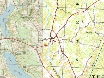
Every edition of the U.S. Geological Survey’s map of Warren. Tap a year, or press play to watch the town change.
1941Rockland sheet · 1:62,500
U.S. Geological Survey historical topographic maps (public domain), via Esri’s collection of the scans. The red ring marks the center of Warren.
Every building
Warren, building by building, 1904–1927
Fire insurance maps drew every building, what it was made of and what it was used for, so insurers could price the risk of fire. Pick a year, then a sheet.
In 1736, according to Wikidata and Wikipedia’s history of the town. Warren’s post office opened in 1878, and the first U.S. census counted 646 people here in 1790.
How does Warren rank for history?
Warren is more historic than 70% of U.S. towns, #101 of 143 in Maine. The History grade combines the town’s founding era, the share of homes built before 1940 and its National Register listings. It’s a character grade, so it isn’t part of the overall grade. How it works.
How old are the homes in Warren?
22% of Warren’s homes were built before 1940 (Census estimate, ±7.8 points), against a typical 19% for a Maine town; the median home was built in 1981.
Founding dates: Wikidata, Wikipedia, the U.S. post office records of Blevins & Helbock (CC0) and the Census. Homes by year built: Census ACS 2020–24. National Register of Historic Places: National Park Service (list of May 22, 2026). Old photos, postcards and papers: Wikimedia Commons, the Library of Congress and other public archives, credited on each item’s page. Maps: U.S. Geological Survey historical topographic maps (via Esri) and Sanborn fire-insurance maps (Library of Congress). History text and census tables: Wikipedia (CC BY-SA 4.0). Places that used to be: USGS Geographic Names Information System (2021).
From Wikimedia Commons (8), the Library of Congress (1), Wikipedia, Wikidata and Wikipedia for famous people, U.S. Geological Survey historical maps, U.S. Census counts (via Wikipedia), the US Post Offices dataset (Blevins & Helbock), the USGS Geographic Names Information System, Sanborn fire insurance maps (Library of Congress) and old county and town histories (Internet Archive). Archive images are copied here with their credits and licenses, shown on each photo’s page. Refreshed monthly.




 1984
 Date?
 Date?
 2017
 2013
 2013
 2012


