More historic than 94% of U.S. towns · #29 of 143 in Maine. What drives it
13 places in town are on the National Register, among them two historic districts with 40 buildings between them. Below: 4 old photos and papers, maps from 1886 on, and the census since 1810.
On its age, its old homes and the National Register, Fryeburg is more historic than 94% of U.S. towns, #29 of 143 in Maine. All 2 inputs are above most U.S. towns; its National Register listings ranks highest and its share of homes from before 1940 lowest.
A
HistoryA character grade: shown, never part of Fryeburg’s overall grade.
Maine towns list more on the Register than most of the country (a typical Maine town has 15.9 per 10,000 residents, the U.S. 2.4), so Fryeburg’s 149 sits above most of its state (90% of Maine towns have fewer) while its 52 historic buildings outnumber those of 85% of U.S. towns.
How sure. Graded on two of the three inputs, so a change in either one moves the letter more than it would with three. The pre-1940 share is a Census survey estimate (±6.0 points).
Founding year: our sources. Homes: Census ACS 2020–24. National Register: National Park Service, May 2026 list; each listing counted once (boundary changes and added documentation belong to their listing), and a historic district counts its contributing buildings. How TownRatings grades history →
What stands out about Fryeburg’s past
Read from the archive, the National Register and the record. The page puts what stands out first.
The area was once a major Abenaki Indigenous peoples of the Americas village known as Pequawket, meaning "crooked place," a reference to the large bend in the Saco River. It was inhabited by the Sokokis tribe, whose territory along the stream extended from what is now Saco on the coast, to Conway, New Hampshire in the White Mountains. In 1706, Chief Nescambious would be the only Native knighted by the French, who referred to Pequawket as Pégouaki. For a while the tribe was not hostile to English settlements, even hiring British carpenters to build at Pequawket a 14-foot (4.3 m) high palisade fort as protection against their traditional enemy, the Mohawks. In 1713, Sokokis sachems signed the Treaty of Portsmouth to ensure peace with English colonists. Eventually, relations with the English soured. During Father Rale's War, Pequawket was attacked in the Battle at Pequawket on May 8, 1725…
Passages that mention Fryeburg, cut from the printed page as they were published.
The history of Waterford, Oxford County, Maine, comprising Historical address, by Henry P. Warren1879 · page 68Read the page →
Read the text
Brownfield (Brownsfield), settled 1765, incorporated 1800, 250 287 Buckfield (Buck-town or No. 5) , settled 1776, incor. 1793, 453 1002 Dixfield,* settled 1795, incorporated 1803, 137 Fryeburg and Stow (Fryeburg-addition, Pequawkett), settled 1763, incorporated 1777, 547 734 Gilead (Peabodys Patent),* settled 1780, incor. 1805, 88 1 The towns starred made no returns of population ; with the exception of Paris they could have had but a handful of settlers each. The
Text read by machine from the scan; it may contain errors.
History of Bethel, formerly Sudbury, Canada, Oxford County, Maine, 1768-18901891 · page 11Read the page →
Read the text
Fryeburg, the first town granted and settled in what is now Oxford county, was settled in seventeen hundred and sixty-two, and Bethel granted in seventeen hundred and sixty-eight, was settled six years later. But in the midst of this general prosperity, the war of the revolution broke out which paralyzed all enterprises and put a stop to all progress for the space of nearly eight years. Many who had just settled in Maine hastened to headquarters and joined the ranks of the patriot army, and many others who were just on
Text read by machine from the scan; it may contain errors.
The history of Waterford, Oxford County, Maine, comprising Historical address, by Henry P. Warren1879 · page 82Read the page →
Read the text
Naturally the clergymen in this council came from a distance, for at this time there was but one Congregational minister within the limits of Oxford county. Rev. William Fessenden of Fryeburg ; there were two Baptist ministers at that time in the county, one at Fryeburg the other at Paris. The growth of Congregationalism in Oxford county was slow, for in 1813 there were but thirteen Congregational
Text read by machine from the scan; it may contain errors.
A history of Buckfield, Oxford County, Maine, from the earliest explorations to the close of the year 19001915 · page 750Read the page →
Read the text
The prayer of the petitioners was granted and the road was located and built. The "Great County Road" was laid out in 1819. It extended from the New Hampshire line, between Fryeburg and Conway to Aug-usta. In Buckfield the following owners of land, localities and places are mentioned in the report of the committee which laid out the road: Josiah Bailey, Ephraim Harlow, Capt. Nathaniel Harlow, Noah Hall, Waterman's Bridge, Job Prince, Mayhews', Buck's Bridge, Squire Buck's, The Liberty Pole, Spaulding's, Village Bridge, Corner Foster's House,
Text read by machine from the scan; it may contain errors.
Scans and text from the Internet Archive. Books published in 1930 or earlier, which are in the public domain.
Timeline
Fryeburg, 1772 to 1909
Woven from the archive, old maps, post office records, the National Register and the people born here.
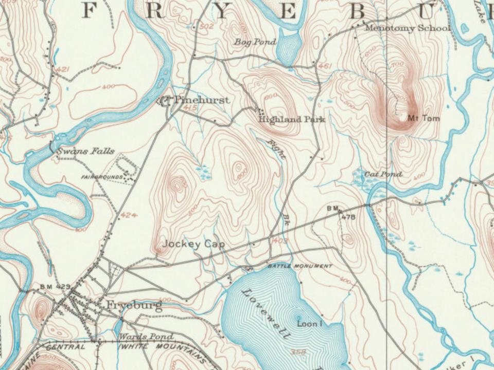
Every edition of the U.S. Geological Survey’s map of Fryeburg. Tap a year, or press play to watch the town change.
1909Fryeburg sheet · 1:62,500
U.S. Geological Survey historical topographic maps (public domain), via Esri’s collection of the scans. The red ring marks the center of Fryeburg.
Every building
Fryeburg, building by building, 1886–1911
Fire insurance maps drew every building, what it was made of and what it was used for, so insurers could price the risk of fire. Pick a year, then a sheet.
1886Sheet 1 of 1
Edition
Sheets
BrickWoodStone
Sanborn Map Company, via the Library of Congress. Editions published in 1930 or earlier, which are in the public domain.
Then & now
Stand where they stood
No then-and-now pairs yet. Take a photo from the same spot as an old one and they appear here side by side.
Retake this viewJockey Cap, Fryeburgh, Me.Alternate Title: American Scenery. 73, c. 1869
Find the spot, match the angle, and add your photo. It becomes the first then-and-now pair on Fryeburg’s page.
Fryeburg is more historic than 94% of U.S. towns, #29 of 143 in Maine. The History grade combines the town’s founding era, the share of homes built before 1940 and its National Register listings. It’s a character grade, so it isn’t part of the overall grade. How it works.
What is on the National Register in Fryeburg?
13 listings: 10 buildings, 2 historic districts, the Main Street Historic District and the Rivercroft Farm, with 40 contributing buildings, and 1 structure. 52 historic buildings in all.
How old are the homes in Fryeburg?
24% of Fryeburg’s homes were built before 1940 (Census estimate, ±6.0 points), against a typical 19% for a Maine town; the median home was built in 1978.
Founding dates: Wikidata, Wikipedia, the U.S. post office records of Blevins & Helbock (CC0) and the Census. Homes by year built: Census ACS 2020–24. National Register of Historic Places: National Park Service (list of May 22, 2026). Old photos, postcards and papers: Wikimedia Commons, the Library of Congress and other public archives, credited on each item’s page. Maps: U.S. Geological Survey historical topographic maps (via Esri) and Sanborn fire-insurance maps (Library of Congress). History text and census tables: Wikipedia (CC BY-SA 4.0). Places that used to be: USGS Geographic Names Information System (2021).
From Wikimedia Commons (4), Wikidata (2), the National Register of Historic Places (13), Wikipedia, Wikidata and Wikipedia for famous people, U.S. Geological Survey historical maps, U.S. Census counts (via Wikipedia), the US Post Offices dataset (Blevins & Helbock), the USGS Geographic Names Information System, Sanborn fire insurance maps (Library of Congress) and old county and town histories (Internet Archive). Archive images are copied here with their credits and licenses, shown on each photo’s page. Refreshed monthly.


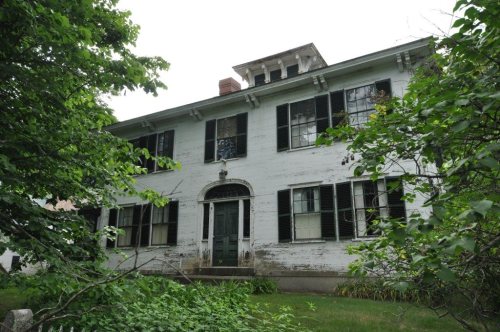


 c. 1869
 c. 1869