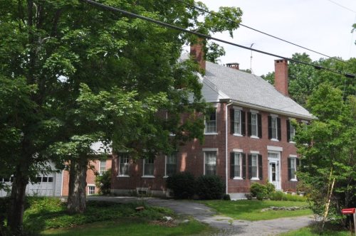
Its Register listings are the Starling Grange #156 (former), the Joseph H. Underwood House and the Kent Burying Ground. Its Register listings are the Starling Grange #156 (former), the Joseph H. Underwood House and the Kent Burying Ground. Below: maps from 1910 on and the census since 1800.
Founding year: Wikipedia. First post office: 1803.The full story ↓
History grade
What drives Fayette’s History grade
On its age, its old homes and the National Register, Fayette is more historic than 79% of U.S. towns. All 3 inputs are above most U.S. towns; its age ranks highest and its National Register listings lowest.
A−
HistoryA character grade: shown, never part of Fayette’s overall grade.
Maine towns list more on the Register than most of the country (a typical Maine town has 15.9 per 10,000 residents, the U.S. 2.4), so Fayette’s 21.7 sits near the middle of its state (61% of Maine towns have fewer) while its 3 listings outnumber those of 65% of U.S. towns.
How sure. Graded on any two of the three inputs instead, the letter would range from B+ to A−. The pre-1940 share is a Census survey estimate (±6.5 points). Two sources give 1781.
Founding year: Wikipedia (other dates in Quick answers). Homes: Census ACS 2020–24. National Register: National Park Service, May 2026 list; each listing counted once (boundary changes and added documentation belong to their listing), and a historic district counts its contributing buildings. How TownRatings grades history →
What stands out about Fayette’s past
Read from the archive, the National Register and the record. The page puts what stands out first.
Fayette was first settled as Sterling (or Starling) Plantation in 1781, and became incorporated as the town of Fayette on February 28, 1795. Other sources state that Starling Plantation was first settled in 1779 on 7,000 acres granted by the State of Massachusetts to "Robert Paige and associates." Further publishings indicate that one Asa Wiggin laid claim to clearing the first land in Starling Plantation in the year 1779. Fayette was named for the Marquis de Lafayette, the French nobleman who offered his services to the Americans during the Revolution. Kent Burying Ground, which was built in 1880, is located in Fayette.
Passages that mention Fayette, cut from the printed page as they were published.
Illustrated history of Kennebec County, Maine1892 · page 963Read the page →
Read the text
Fayette is located five miles distant, and midway between the Farmington branch and the main stem of the Maine Central railroad, consequently we labor under the disadvantage of higher transportation than that of railroad towns. Whenever the contemplated and already chartered railroad shall be constructed, in all probability it will pass up the Thirty Mile river, so-called, entering the towns of Wayne, Fayette, Mt. Vernon and Vienna, touching or going in close proximity to seven excellent water powers in a distance of fifteen
Text read by machine from the scan; it may contain errors.
Illustrated history of Kennebec County, Maine1892 · page 267Read the page →
Read the text
The chapter on Tlie Town of Fayette in this work is from the pen of George Underwood, of Fayette. Mr. Underwood is also an occasional contributor to several newspapers.
Text read by machine from the scan; it may contain errors.
Scans and text from the Internet Archive. Books published in 1930 or earlier, which are in the public domain.
Timeline
Fayette, 1781 to 2020
Woven from the archive, old maps, post office records, the National Register and the people born here.
In 1781, according to Wikipedia’s history of the town. Fayette’s post office opened in 1803, and the census of 1800 counted 532 people here.
How does Fayette rank for history?
Fayette is more historic than 79% of U.S. towns. The History grade combines the town’s founding era, the share of homes built before 1940 and its National Register listings. It’s a character grade, so it isn’t part of the overall grade. How it works.
What is on the National Register in Fayette?
Three places: the Starling Grange #156 (former), the Joseph H. Underwood House (2005) and the Kent Burying Ground (2008).
How old are the homes in Fayette?
18% of Fayette’s homes were built before 1940 (Census estimate, ±6.5 points), against a typical 19% for a Maine town; the median home was built in 1986.
Founding dates: Wikidata, Wikipedia, the U.S. post office records of Blevins & Helbock (CC0) and the Census. Homes by year built: Census ACS 2020–24. National Register of Historic Places: National Park Service (list of May 22, 2026). Old photos, postcards and papers: Wikimedia Commons, the Library of Congress and other public archives, credited on each item’s page. Maps: U.S. Geological Survey historical topographic maps (via Esri) and Sanborn fire-insurance maps (Library of Congress). History text and census tables: Wikipedia (CC BY-SA 4.0). Places that used to be: USGS Geographic Names Information System (2021).
From Wikimedia Commons (8), the National Register of Historic Places (3), Wikipedia, U.S. Geological Survey historical maps, U.S. Census counts (via Wikipedia), the US Post Offices dataset (Blevins & Helbock), the USGS Geographic Names Information System and old county and town histories (Internet Archive). Archive images are copied here with their credits and licenses, shown on each photo’s page. Refreshed monthly.


 2022
 2022
 2022
 2021
 2021
 2006
 2006
 2000