Montague dates to 1715, and 45% of its homes were built before 1940
Among the most historic 1% of U.S. towns · #6 of 283 in Massachusetts. What drives it
4 places in town are on the National Register, among them four historic districts with 454 buildings between them. Below: 12 old photos and papers, maps from 1890 on, and the census since 1790.
Founding year: Wikidata; Wikipedia’s history section gives the same year. First post office: 1815.The full story ↓
History grade
What drives Montague’s History grade
On its age, its old homes and the National Register, Montague is among the most historic 1% of U.S. towns, #6 of 283 in Massachusetts. All 3 inputs put Montague near the top nationally; its share of homes from before 1940 ranks highest.
A+
HistoryA character grade: shown, never part of Montague’s overall grade.
Massachusetts towns list more on the Register than most of the country (a typical Massachusetts town has 46.0 per 10,000 residents, the U.S. 2.4), so Montague’s 535 sits above most of its state (93% of Massachusetts towns have fewer) while its 454 historic buildings outnumber those of 97% of U.S. towns.
How sure. Graded on any two of the three inputs instead, the letter would still be A+. The pre-1940 share is a Census survey estimate (±6.1 points). Two sources give 1715.
Founding year: Wikidata (other dates in Quick answers). Homes: Census ACS 2020–24. National Register: National Park Service, May 2026 list; each listing counted once (boundary changes and added documentation belong to their listing), and a historic district counts its contributing buildings. How TownRatings grades history →
What stands out about Montague’s past
Read from the archive, the National Register and the record. The page puts what stands out first.
Originally inhabited by the Pocomtuc tribe, the area was known as Peskeompskut. Montague was first settled by Europeans in 1715 and was incorporated in 1754. The town has five villages within it: Montague Center, Montague City, Turners Falls, Millers Falls, and Lake Pleasant. Montague Center was the original European settlement and was originally a part of the town of Sunderland. Lake Pleasant was a prominent spiritualist campground. Turners Falls was a planned mill community (similar to but less successful than that at Lowell, Massachusetts) that developed when the canal was converted to use for power production rather than transportation in the mid-19th century. Between 1974 and 1980, the Montague Nuclear Power Plant was proposed for construction in the town. In October 2010, the village of Turners Falls hosted the 1st annual Franklin County Pumpkinfest, now known as The Great Falls…
Passages that mention Montague, cut from the printed page as they were published.
History of the town of Bernardston, Franklin county, Massachusetts. 1736-1900. With genealogies1902 · page 155Read the page →
Read the text
In 185 1 and again in 1832, Mr. Andrews ably represented the town of Montague in legislative halls as Representative, while in 1855 he was sent as Senator from Franklin County. For seven years he was an active member of the board of trustees of the Shelburne Falls Academy. In 1859 the honorary degree of A. M. was conferred upon him by Brown University. Thus we see that Mr.
Text read by machine from the scan; it may contain errors.
History of the town of Bernardston, Franklin county, Massachusetts. 1736-1900. With genealogies1902 · page 64Read the page →
Read the text
der and Jason Brown. They advertised to manufacture wool on shares. Up to 1828 John Wait and Jason Brown were in company, then the business was advertised as being for sale, also a sawmill on the premises. This was later owned by Richard Montague, being purchased by him of Truman Shattuck, and this was the one owned by Col. Ferry and A. Weatherhead. About 1810 Oliver and Ruggles Bagg began to run a carding machine and fulling mill on the west branch of Fall River, west of the old Chase tavern. This
Text read by machine from the scan; it may contain errors.
Scans and text from the Internet Archive. Books published in 1930 or earlier, which are in the public domain.
Timeline
Montague, 1715 to 1963
Woven from the archive, old maps, post office records, the National Register and the people born here.
Nothing in the archives for these yearsWeddings on Main Street, storms, parades, school pictures, the old store. If it’s in your family album, it belongs here.
In 1715, according to Wikidata and Wikipedia’s history of the town. Montague’s post office opened in 1815, and the first U.S. census counted 906 people here in 1790.
How does Montague rank for history?
Montague is among the most historic 1% of U.S. towns, #6 of 283 in Massachusetts. The History grade combines the town’s founding era, the share of homes built before 1940 and its National Register listings. It’s a character grade, so it isn’t part of the overall grade. How it works.
What is on the National Register in Montague?
4 listings: 4 historic districts with 454 contributing buildings. 454 historic buildings in all.
How old are the homes in Montague?
45% of Montague’s homes were built before 1940 (Census estimate, ±6.1 points), against a typical 21% for a Massachusetts town; the median home was built in 1951.
Founding dates: Wikidata, Wikipedia, the U.S. post office records of Blevins & Helbock (CC0) and the Census. Homes by year built: Census ACS 2020–24. National Register of Historic Places: National Park Service (list of May 22, 2026). Old photos, postcards and papers: Wikimedia Commons, the Library of Congress and other public archives, credited on each item’s page. Maps: U.S. Geological Survey historical topographic maps (via Esri) and Sanborn fire-insurance maps (Library of Congress). History text and census tables: Wikipedia (CC BY-SA 4.0). Places that used to be: USGS Geographic Names Information System (2021).
From Wikimedia Commons (12), the National Register of Historic Places (4), Wikipedia, Wikidata and Wikipedia for famous people, U.S. Geological Survey historical maps, U.S. Census counts (via Wikipedia), the US Post Offices dataset (Blevins & Helbock), the USGS Geographic Names Information System, Sanborn fire insurance maps (Library of Congress) and old county and town histories (Internet Archive). Archive images are copied here with their credits and licenses, shown on each photo’s page. Refreshed monthly.


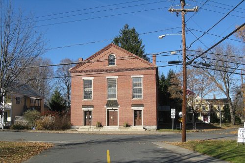


 1907
 1907
 1908
 1909
 1910
 1912
 1912
 1931


