Marshfield dates to 1632, and 13% of its homes were built before 1940
More historic than 86% of U.S. towns · #173 of 283 in Massachusetts. What drives it
6 places in town are on the National Register, among them the Webster, Daniel, Law Office and Library, a National Historic Landmark, and two historic districts with 121 buildings between them. Below: 18 old photos and papers, maps from 1885 on, and the census since 1790.
On its age, its old homes and the National Register, Marshfield is more historic than 86% of U.S. towns, #173 of 283 in Massachusetts. All 3 inputs are above most U.S. towns; its age ranks highest and its share of homes from before 1940 lowest.
A
HistoryA character grade: shown, never part of Marshfield’s overall grade.
Massachusetts towns list more on the Register than most of the country (a typical Massachusetts town has 46.0 per 10,000 residents, the U.S. 2.4), so Marshfield’s 49.1 sits near the middle of its state (49% of Massachusetts towns have fewer) while its 127 historic buildings outnumber those of 91% of U.S. towns.
NoteThe founding year comes from Wikidata alone; no second source gives 1632.
How sure. Graded on any two of the three inputs instead, the letter would range from B+ to A. The pre-1940 share (±2.9 points) is firm at this size.
Founding year: Wikidata (other dates in Quick answers). Homes: Census ACS 2020–24. National Register: National Park Service, May 2026 list; each listing counted once (boundary changes and added documentation belong to their listing), and a historic district counts its contributing buildings. How TownRatings grades history →
What stands out about Marshfield’s past
Read from the archive, the National Register and the record. The page puts what stands out first.
Brant Rock Village Post Officepost officeEast Marshfield StationlocaleGreen Harbor Village Post Officepost officeMarshfield Centre Post Officepost officeMarshfield Centre StationlocaleMarshfield Hills Post Officepost officeMarshfield Post Officepost officeMarshfield StationlocaleNorth Marshfield Post Officepost officeSea View Post Officepost officeSea View StationlocaleWebster Point Stationlocale
4cemeteries and burying grounds inside Marshfield
LittlesMagounTwo MileWinslow
US Post Offices dataset (Blevins & Helbock, CC0). Places and cemeteries from the USGS Geographic Names Information System (2021).
The story so far
Marshfield, in brief
Wikipedia doesn’t have a history of Marshfield yet. The photos, dates and memories neighbors add here are how it gets written.
Marshfield is a town in Plymouth County, Massachusetts, United States, on Massachusetts's South Shore. The population was 25,825 at the 2020 census. It includes the census-designated places (CDPs) of Marshfield, Marshfield Hills, Ocean Bluff-Brant Rock, and Cedar Crest, and shares the Green Harbor CDP with the town of Duxbury.
Marshfield was established in 1632. Between the 2010 and 2020 censuses its population grew from 25,132 to 25,825 (+3%).
Intro from Wikipedia. Population: U.S. Census Bureau.
From the old history books
What they wrote about Marshfield, 1889–1897
Passages that mention Marshfield, cut from the printed page as they were published.
History of shipbuilding on North river, Plymouth county, Massachusetts, with genealogies of the shipbuilders, and accounts of the industries upon its tributaries. 1640 to 18721889 · page 36Read the page →
Read the text
landing at this ferry (which was called the Upper Ferry) in 1G45. ° At this point, North Eiver is about seven to eight rods wide at ordinary tide. The " Upper Ferry " Avas run by the Oakraans* of Marshfield until later than 1760-70, about which time John Tolman took charge ; and he was the last ferryman before the bridge was built. " In 1709 it was proposed by the Town of Scituate to build and maintain a bridge over North Eiver, at Oahnan's Ferry, jointly with Marshfield. Three
Text read by machine from the scan; it may contain errors.
History of shipbuilding on North river, Plymouth county, Massachusetts, with genealogies of the shipbuilders, and accounts of the industries upon its tributaries. 1640 to 18721889 · page 350Read the page →
Read the text
T^HE Keenesand the Halls built at these yards for many years, ■*- but they were prol)ably occupied nearly a hundred years prior to their time. As early as 1705 we find there was built in Marshfield the sloop " MAEY & ABIGAIL," 40 tons ; owners, Bethia Little, widow, of Boston, Isaac Little, of Marshfield, and John Henshaw, of Boston. In 1711, the ship " TAUNTON MERCHANT," 70 tons, was built at Marshfield ; owners, James Cooks, of Cullumstock, James Norman, John
Text read by machine from the scan; it may contain errors.
History of the early settlement of Bridgewater in Plymouth county, Massachusetts, including an extensive Family register1897Read the page →
Read the text
When the township of Marshfield became a separate and distinct corporation, Duxbury, from which Marshfield had been principally taken, applied to the Old Colony court, at Plymouth, for a grant of common land, or, as they expressed it, "an extension to the westward," as a compensation for the great loss of territory they had thus sustained. We find in the records the following order of court relating to it : — " March, 1642. It is concluded upon by the court, that the
Text read by machine from the scan; it may contain errors.
Scans and text from the Internet Archive. Books published in 1930 or earlier, which are in the public domain.
By decade
Marshfield, decade by decade
7 decades in the archive, from the 1840s to the 1900s. Scroll each row; tap a photo for its story.
Nothing in the archives for these yearsWeddings on Main Street, storms, parades, school pictures, the old store. If it’s in your family album, it belongs here.
Every edition of the U.S. Geological Survey’s map of Marshfield. Tap a year, or press play to watch the town change.
1885Duxbury sheet · 1:62,500
U.S. Geological Survey historical topographic maps (public domain), via Esri’s collection of the scans. The red ring marks the center of Marshfield.
Every building
Marshfield, building by building, 1916–1925
Fire insurance maps drew every building, what it was made of and what it was used for, so insurers could price the risk of fire. Pick a year, then a sheet.
In 1632, according to Wikidata. Marshfield’s post office opened in 1800, and the first U.S. census counted 1,269 people here in 1790.
How does Marshfield rank for history?
Marshfield is more historic than 86% of U.S. towns, #173 of 283 in Massachusetts. The History grade combines the town’s founding era, the share of homes built before 1940 and its National Register listings. It’s a character grade, so it isn’t part of the overall grade. How it works.
What is on the National Register in Marshfield?
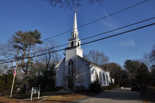
6 listings: 3 buildings, among them the Webster, Daniel, Law Office and Library (a National Historic Landmark since 1974), 2 historic districts, the Hatch Homestead and Mill Historic District and the Marshfield Hills Historic District, with 121 contributing buildings, and 1 site. 127 historic buildings in all.
How old are the homes in Marshfield?
13% of Marshfield’s homes were built before 1940 (Census estimate, ±2.9 points), against a typical 21% for a Massachusetts town; the median home was built in 1968.
Founding dates: Wikidata, Wikipedia, the U.S. post office records of Blevins & Helbock (CC0) and the Census. Homes by year built: Census ACS 2020–24. National Register of Historic Places: National Park Service (list of May 22, 2026). Old photos, postcards and papers: Wikimedia Commons, the Library of Congress and other public archives, credited on each item’s page. Maps: U.S. Geological Survey historical topographic maps (via Esri) and Sanborn fire-insurance maps (Library of Congress). History text and census tables: Wikipedia (CC BY-SA 4.0). Places that used to be: USGS Geographic Names Information System (2021).
From Wikimedia Commons (15), the Library of Congress (3), the National Register of Historic Places (6), Wikidata and Wikipedia for famous people, U.S. Geological Survey historical maps, U.S. Census counts (via Wikipedia), the US Post Offices dataset (Blevins & Helbock), the USGS Geographic Names Information System, Sanborn fire insurance maps (Library of Congress) and old county and town histories (Internet Archive). Archive images are copied here with their credits and licenses, shown on each photo’s page. Refreshed monthly.


 ★ Landmark




 1852
 1889
 1895
 1896
 1906
 1906
 1907–1915
 1907–1915
 1907–1915
 1907–1915
 1907–1915
 1907–1915


