Grafton dates to 1718, and 14% of its homes were built before 1940
More historic than 92% of U.S. towns · #121 of 283 in Massachusetts. What drives it
8 places in town are on the National Register, among them three historic districts with 398 buildings between them. Below: 7 old photos and papers, maps from 1885 on, and the census since 1790.
Founding year: Wikidata. First post office: 1811.The full story ↓
History grade
What drives Grafton’s History grade
On its age, its old homes and the National Register, Grafton is more historic than 92% of U.S. towns, #121 of 283 in Massachusetts. All 3 inputs are above most U.S. towns; its age ranks highest and its share of homes from before 1940 lowest.
A
HistoryA character grade: shown, never part of Grafton’s overall grade.
Massachusetts towns list more on the Register than most of the country (a typical Massachusetts town has 46.0 per 10,000 residents, the U.S. 2.4), so Grafton’s 205 sits above most of its state (77% of Massachusetts towns have fewer) while its 407 historic buildings outnumber those of 96% of U.S. towns.
NoteThe founding year comes from Wikidata alone; no second source gives 1718.
How sure. Graded on any two of the three inputs instead, the letter would range from A− to A+. The pre-1940 share (±2.7 points) is firm at this size.
Founding year: Wikidata (other dates in Quick answers). Homes: Census ACS 2020–24. National Register: National Park Service, May 2026 list; each listing counted once (boundary changes and added documentation belong to their listing), and a historic district counts its contributing buildings. How TownRatings grades history →
What stands out about Grafton’s past
Read from the archive, the National Register and the record. The page puts what stands out first.
Bands of the Nipmuc tribe are the indigenous inhabitants, and maintain a state-recognized reservation known as Hassanamesit, or Hassanamisco, which was formerly a Praying Indian village from 1647 when the Reverend John Eliot came and converted the Hassanamiscos to Christianity . in 1727 the Hassanamesit reservation of 8,000 acres was divided into 7,500 acres to 40 English proprietors and 500 acres to 7 Nipmuc proprietors. This became Grafton, officially incorporated in 1735.
Grafton stands tall in the industrialization of the Blackstone Valley. Its Northeast Village was once known as "New England Village". The following is an excerpt from the Blackstone Daily about the history of the town:
Passages that mention Grafton, cut from the printed page as they were published.
History of Grafton, Worcester county, Massachusetts, from its early settlement by the Indians in 1647 to the present time, 1879. Including the genealogies of seventy-nine of the older families1879 · page 66Read the page →
Read the text
Your petitioners therefore humbly pray, together with the town of Grafton, that your petitioners, with their lands, according to the vote and procedure of the town of Shrewsbury, as also all that strip or point of Sutton lands that lay between said Shrewsbury and Grafton, which is about two miles and a half from Grafton meeting-house, and about
Text read by machine from the scan; it may contain errors.
History of Grafton, Worcester county, Massachusetts, from its early settlement by the Indians in 1647 to the present time, 1879. Including the genealogies of seventy-nine of the older families1879 · page 64Read the page →
Read the text
pray that they may be released from their bond to maintain preaching and schooling for the Indians. As to which petition tlie proprietors and town of Grafton beg leave to say: That said committee was chose a year and a half ago, not to complain of the town as they have done, but upon another affair, and therefore they had nt) right so to do, doing it of their own hands, and not 'probond' that they therein acted the minds of the proprietors of the town of
Text read by machine from the scan; it may contain errors.
[Extract from Town Records.] "In 1777, agreeable to act of Court entitled 'An Act to prevent monopoly and oppression,' the Selectmen and Committee of the Town of Grafton have met and affixt and settled the price of articles hereafter mentioned, viz : — s. d.
Text read by machine from the scan; it may contain errors.
Scans and text from the Internet Archive. Books published in 1930 or earlier, which are in the public domain.
Timeline
Grafton, 1718 to 1985
Woven from the archive, old maps, post office records, the National Register and the people born here.
Nothing in the archives for these yearsWeddings on Main Street, storms, parades, school pictures, the old store. If it’s in your family album, it belongs here.
Nothing in the archives for these yearsWeddings on Main Street, storms, parades, school pictures, the old store. If it’s in your family album, it belongs here.
Fire insurance maps drew every building, what it was made of and what it was used for, so insurers could price the risk of fire. Pick a year, then a sheet.
In 1718, according to Wikidata. Grafton’s post office opened in 1811, and the first U.S. census counted 872 people here in 1790.
How does Grafton rank for history?
Grafton is more historic than 92% of U.S. towns, #121 of 283 in Massachusetts. The History grade combines the town’s founding era, the share of homes built before 1940 and its National Register listings. It’s a character grade, so it isn’t part of the overall grade. How it works.
What is on the National Register in Grafton?
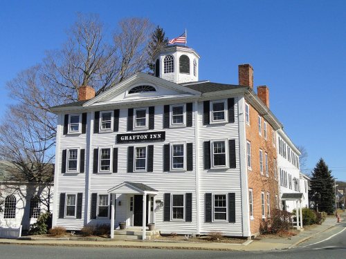
8 listings: 4 buildings, among them the Grafton Inn (listed 1980, the first), 3 historic districts, the Grafton Common Historic District, the Farnumsville Historic District and the Fisherville Historic District, with 398 contributing buildings, and 1 site. 407 historic buildings in all.
How old are the homes in Grafton?
14% of Grafton’s homes were built before 1940 (Census estimate, ±2.7 points), against a typical 21% for a Massachusetts town; the median home was built in 1977.
Founding dates: Wikidata, Wikipedia, the U.S. post office records of Blevins & Helbock (CC0) and the Census. Homes by year built: Census ACS 2020–24. National Register of Historic Places: National Park Service (list of May 22, 2026). Old photos, postcards and papers: Wikimedia Commons, the Library of Congress and other public archives, credited on each item’s page. Maps: U.S. Geological Survey historical topographic maps (via Esri) and Sanborn fire-insurance maps (Library of Congress). History text and census tables: Wikipedia (CC BY-SA 4.0). Places that used to be: USGS Geographic Names Information System (2021).
From Wikimedia Commons (10), the Library of Congress (1), Wikidata (1), the National Register of Historic Places (8), Wikipedia, Wikidata and Wikipedia for famous people, U.S. Geological Survey historical maps, U.S. Census counts (via Wikipedia), the US Post Offices dataset (Blevins & Helbock), the USGS Geographic Names Information System, Sanborn fire insurance maps (Library of Congress) and old county and town histories (Internet Archive). Archive images are copied here with their credits and licenses, shown on each photo’s page. Refreshed monthly.








 1887
 1910
 2009
 2009
 2007
 2006


