Westborough dates to 1675, and 13% of its homes were built before 1940
More historic than 93% of U.S. towns · #115 of 283 in Massachusetts. What drives it
8 places in town are on the National Register, among them four historic districts with 576 buildings between them. Below: 22 old photos and papers, maps from 1887 on, and the census since 1790.
Founding year: Wikidata. First post office: 1811.The full story ↓
History grade
What drives Westborough’s History grade
On its age, its old homes and the National Register, Westborough is more historic than 93% of U.S. towns, #115 of 283 in Massachusetts. All 3 inputs are above most U.S. towns; its age ranks highest and its share of homes from before 1940 lowest.
A
HistoryA character grade: shown, never part of Westborough’s overall grade.
Massachusetts towns list more on the Register than most of the country (a typical Massachusetts town has 46.0 per 10,000 residents, the U.S. 2.4), so Westborough’s 301 sits above most of its state (84% of Massachusetts towns have fewer) while its 661 historic buildings outnumber those of 98% of U.S. towns.
NoteThe founding year comes from Wikidata alone; no second source gives 1675.
How sure. Graded on any two of the three inputs instead, the letter would range from A− to A+. The pre-1940 share (±2.0 points) is firm at this size.
Founding year: Wikidata (other dates in Quick answers). Homes: Census ACS 2020–24. National Register: National Park Service, May 2026 list; each listing counted once (boundary changes and added documentation belong to their listing), and a historic district counts its contributing buildings. How TownRatings grades history →
What stands out about Westborough’s past
Read from the archive, the National Register and the record. The page puts what stands out first.
Before recorded time, the area now known as Westborough was a well-travelled crossroads. As early as 7,000 BCE, prehistoric people in dugout canoes followed the Sudbury and Assabet Rivers to their headwaters in search of quartzite for tools and weapons.
From 1200 to 1600 CE, seasonal migrations brought Nipmuc Indians to hunt and fish near Cedar Swamp and Lake Hoccomocco. Using Fay Mountain as a landmark, Indians crisscrossed Westborough on well-worn paths: the old Connecticut Path leading west from Massachusetts Bay; the Narragansett Trail leading south, and the trail (along the present Milk Street) leading to Canada.
Passages that mention Westborough, cut from the printed page as they were published.
The history of Westborough, Massachusetts. Part I. The early history. By Heman Packard De Forest. Part II. The later history. By Edward Craig Bates1891Read the page →
Read the text
His son, Elijah Whitney, bought the farm, and in the year 1792 petitioned for annexation to Westborough. He says that his farm of forty acres is situated in Shrewsbury, but " is incircled with land within the limits of the Town of Westborough, whereby your petitioner is subject to the Evil of passing through some part of Westborough in Order to appear in the Town of Shrewsbury, to attend his Municipal dutys in said Shrewsbury, as well as that of travelling as much as two miles further than it is to the centre of said West-
Text read by machine from the scan; it may contain errors.
The history of Westborough, Massachusetts. Part I. The early history. By Heman Packard De Forest. Part II. The later history. By Edward Craig Bates1891Read the page →
Read the text
The history of the first precinct comes to an end in 1766, when the second precinct is incorporated as the town of Northborough, and the first becomes the town of Westborough, with its present boundaries. A division of common property was made by the selectmen of the two towns, with the exception of the ministerial lot, which remained a matter of dispute for eighteen years longer.
Text read by machine from the scan; it may contain errors.
Scans and text from the Internet Archive. Books published in 1930 or earlier, which are in the public domain.
By decade
Westborough, decade by decade
4 decades in the archive, from the 1780s to the 1930s. Scroll each row; tap a photo for its story.
Nothing in the archives for these yearsWeddings on Main Street, storms, parades, school pictures, the old store. If it’s in your family album, it belongs here.
In 1675, according to Wikidata. Westborough’s post office opened in 1811, and the first U.S. census counted 933 people here in 1790.
How does Westborough rank for history?
Westborough is more historic than 93% of U.S. towns, #115 of 283 in Massachusetts. The History grade combines the town’s founding era, the share of homes built before 1940 and its National Register listings. It’s a character grade, so it isn’t part of the overall grade. How it works.
What is on the National Register in Westborough?
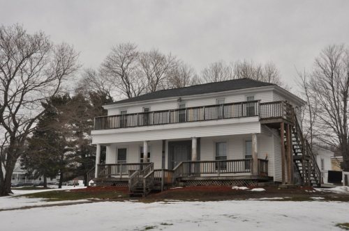
8 listings: 4 buildings, among them the Maples Cottage (listed 1980, the first), and 4 historic districts with 576 contributing buildings. 661 historic buildings in all.
How old are the homes in Westborough?
13% of Westborough’s homes were built before 1940 (Census estimate, ±2.0 points), against a typical 21% for a Massachusetts town; the median home was built in 1976.
Founding dates: Wikidata, Wikipedia, the U.S. post office records of Blevins & Helbock (CC0) and the Census. Homes by year built: Census ACS 2020–24. National Register of Historic Places: National Park Service (list of May 22, 2026). Old photos, postcards and papers: Wikimedia Commons, the Library of Congress and other public archives, credited on each item’s page. Maps: U.S. Geological Survey historical topographic maps (via Esri) and Sanborn fire-insurance maps (Library of Congress). History text and census tables: Wikipedia (CC BY-SA 4.0). Places that used to be: USGS Geographic Names Information System (2021).
From Wikimedia Commons (24), the National Register of Historic Places (8), Wikipedia, Wikidata and Wikipedia for famous people, U.S. Geological Survey historical maps, U.S. Census counts (via Wikipedia), the US Post Offices dataset (Blevins & Helbock), the USGS Geographic Names Information System and old county and town histories (Internet Archive). Archive images are copied here with their credits and licenses, shown on each photo’s page. Refreshed monthly.







 1789
 1789
 1789
 1901–1907
 c. 1905
 1907–1915
 c. 1907
 c. 1909
 1917
 c. 1930
 c. 1930
 c. 1930
 c. 1930
 c. 1930
 c. 1930
 c. 1930
 c. 1930
 c. 1930
 2007
 2005