Dudley dates to 1714, and 24% of its homes were built before 1940
More historic than 92% of U.S. towns · #126 of 283 in Massachusetts. What drives it
4 places in town are on the National Register, among them two historic districts with 40 buildings between them. Below: 1 old photo or paper, maps from 1889 on, and the census since 1790.
On its age, its old homes and the National Register, Dudley is more historic than 92% of U.S. towns, #126 of 283 in Massachusetts. All 3 inputs are above most U.S. towns; its age ranks highest and its National Register listings lowest.
A
HistoryA character grade: shown, never part of Dudley’s overall grade.
Massachusetts towns list more on the Register than most of the country (a typical Massachusetts town has 46.0 per 10,000 residents, the U.S. 2.4), so Dudley’s 39.4 sits near the middle of its state (44% of Massachusetts towns have fewer) while its 47 historic buildings outnumber those of 84% of U.S. towns.
NoteThe founding year comes from Wikidata alone; no second source gives 1714.
How sure. Graded on any two of the three inputs instead, the letter would range from A− to A+. The pre-1940 share is a Census survey estimate (±5.8 points).
Founding year: Wikidata (other dates in Quick answers). Homes: Census ACS 2020–24. National Register: National Park Service, May 2026 list; each listing counted once (boundary changes and added documentation belong to their listing), and a historic district counts its contributing buildings. How TownRatings grades history →
What stands out about Dudley’s past
Read from the archive, the National Register and the record. The page puts what stands out first.
Dudley was first carved out of Nipmuc land purchased by Colonial administrators, Joseph Dudley and William Stoughton in 1681. The new town was first settled in 1714 and was officially incorporated in 1732. The town was named for proprietors William and Paul Dudley.
Before the town was settled, the area of Dudley Hill was a precontact Nipmuc village, centered around Lake Chaubunagungamaug, which was overlooked by Reverend John Eliot. The French River that runs along the town line between Webster and Dudley, was named after a local Huguenot settlement led by Gabriel Bernon.
Passages that mention Dudley, cut from the printed page as they were published.
An anniversary discourse, delivered at Dudley, Massachusetts, March 20, 1853. With topographical and historical notices of the town1853Read the page →
Read the text
part of what now falls within the limits of Southbridge, and a considerable portion of what now constitutes the township of Webster. The former of these townships, embracing the eastern part of Sturbridgc and a contiguous portion of Dudley and Charlton, was incorporated in I81G. The latter, including what had been the eastern portion of Dudley, with the south gore of Oxford, so called, and a part of the township of Oxford itself, received its honored name and corporate powers in the year
Text read by machine from the scan; it may contain errors.
An anniversary discourse, delivered at Dudley, Massachusetts, March 20, 1853. With topographical and historical notices of the town1853Read the page →
Read the text
The present name of the town was probably given to it, in the Act of Incorporation, in memory of Thomas Dudley, one of the earliest Governors and most highly respected magistrates of Massachusetts ; or of his son, Joseph Dudley, who was also a Governor and Judge in his time ; or rather, perhaps, in honor of two of his sons, Paul Dudley, for a time Chief Justice of the province, and Col. William Dudley, his brother, both of Roxbury, where they, and their father and grandfather lived and died.
Text read by machine from the scan; it may contain errors.
History of Worcester County, Massachusetts, embracing a comprehensive history of the county from its first settlement to the present time1879 · page 456Read the page →
Read the text
poralion a source of much controversy, but these were finally established, in 18-11, as follows: The Connecticut State line forms the southern boundary; the (own of Douglas the eastern ; tlic town of Oxford the norther:! ; the French River and the town of Dudley the Western. It is a small township, not exceeding four miles in length, north and south, and three and a half tu width. Its area is fourteen scjuare miles, or about nine thousand acres. The distan(!0 from Boston is fifty-five miles west-south-west, and its latitude is 41° 5G' north, and longitude 5° 10' east from Washington.
Text read by machine from the scan; it may contain errors.
Scans and text from the Internet Archive. Books published in 1930 or earlier, which are in the public domain.
Timeline
Dudley, 1714 to 1997
Woven from the archive, old maps, post office records, the National Register and the people born here.
Nothing in the archives for these yearsWeddings on Main Street, storms, parades, school pictures, the old store. If it’s in your family album, it belongs here.
In 1714, according to Wikidata. Dudley’s post office opened in 1811, and the first U.S. census counted 1,114 people here in 1790.
How does Dudley rank for history?
Dudley is more historic than 92% of U.S. towns, #126 of 283 in Massachusetts. The History grade combines the town’s founding era, the share of homes built before 1940 and its National Register listings. It’s a character grade, so it isn’t part of the overall grade. How it works.
What is on the National Register in Dudley?
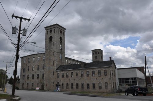
4 listings: 2 buildings, among them the Black Tavern (listed 1985, the first), and 2 historic districts, the Stevens Linen Works Historic District and the Dudley Hill Historic District, with 40 contributing buildings. 47 historic buildings in all.
How old are the homes in Dudley?
24% of Dudley’s homes were built before 1940 (Census estimate, ±5.8 points), against a typical 21% for a Massachusetts town; the median home was built in 1967.
Founding dates: Wikidata, Wikipedia, the U.S. post office records of Blevins & Helbock (CC0) and the Census. Homes by year built: Census ACS 2020–24. National Register of Historic Places: National Park Service (list of May 22, 2026). Old photos, postcards and papers: Wikimedia Commons, the Library of Congress and other public archives, credited on each item’s page. Maps: U.S. Geological Survey historical topographic maps (via Esri) and Sanborn fire-insurance maps (Library of Congress). History text and census tables: Wikipedia (CC BY-SA 4.0). Places that used to be: USGS Geographic Names Information System (2021).
From Wikimedia Commons (13), Wikidata (2), the National Register of Historic Places (4), Wikipedia, Wikidata and Wikipedia for famous people, U.S. Geological Survey historical maps, U.S. Census counts (via Wikipedia), the US Post Offices dataset (Blevins & Helbock), the USGS Geographic Names Information System and old county and town histories (Internet Archive). Archive images are copied here with their credits and licenses, shown on each photo’s page. Refreshed monthly.




 2021
 2021
 2021
 2021
 2021
 2018
 2016
 2012
 2012
 2012
 2012
 2010


