Guest, Sign inJoin

Post to Dartmouth

We’ll email a one-tap link to publish your post. No password, and nothing is public until you click it.
Already a member? Sign in
AHistory
History · Dartmouth

Dartmouth dates to 1650, and 18% of its homes were built before 1940

More historic than 92% of U.S. towns · #129 of 283 in Massachusetts. What drives it

7 places in town are on the National Register, among them four historic districts with 212 buildings between them. Below: 3 old photos and papers, maps from 1888 on, and the census since 1790.

1650founded
7on the National Register
18%homes built before 1940
3old photos & papers
10famous people
From Dartmouth’s archive · credits on each photo
Quick answers

How Dartmouth began, and where its name came from

When was Dartmouth founded?

1650

Dartmouth dates its founding to 1650 (Wikidata). It appears in the first U.S. census, 1790.

First census: 2,499 in 17902020 census: 33,783376 years

How did Dartmouth get its name?

The town is named after Dartmouth, England.

How historic is Dartmouth?

A

More historic than 92% of U.S. towns, on its age, its old homes and the National Register.

What drives the grade ↓
Founding year: Wikidata. First post office: 1810. Name: Wikipedia, licensed CC BY-SA 4.0.The full story ↓
History grade

What drives Dartmouth’s History grade

On its age, its old homes and the National Register, Dartmouth is more historic than 92% of U.S. towns, #129 of 283 in Massachusetts. All 3 inputs are above most U.S. towns; its age ranks highest and its share of homes from before 1940 lowest.

A
HistoryA character grade: shown, never part of Dartmouth’s overall grade.
All U.S. towns we grade (21,289)Ahead of 92%
NewerOlder
Massachusetts towns of 2,500+ (283)Ahead of 55%

Massachusetts towns list more on the Register than most of the country (a typical Massachusetts town has 46.0 per 10,000 residents, the U.S. 2.4), so Dartmouth’s 64.8 sits near the middle of its state (56% of Massachusetts towns have fewer) while its 216 historic buildings outnumber those of 94% of U.S. towns.

NoteThe founding year comes from Wikidata alone; no second source gives 1650.
How sure. Graded on any two of the three inputs instead, the letter would range from A− to A. The pre-1940 share (±2.9 points) is firm at this size.

Founding year: Wikidata (other dates in Quick answers). Homes: Census ACS 2020–24. National Register: National Park Service, May 2026 list; each listing counted once (boundary changes and added documentation belong to their listing), and a historic district counts its contributing buildings. How TownRatings grades history →

What stands out about Dartmouth’s past

Read from the archive, the National Register and the record. The page puts what stands out first.

★ What stands out · On the National Register

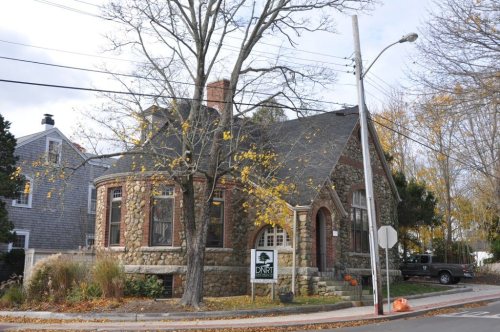
7 listings protect 216 historic buildings

The country’s official list of buildings and places worth saving.

places listed
7
National Historic Landmarks
0
none yet
historic buildings protected
216
each building in a district counts
first listed
1980
Hill School

National Park Service, National Register of Historic Places. Photos from Wikimedia Commons, credited on each place’s page.

Places that used to be

Lost post offices, old corners, places now gone and burying grounds

Dartmouth’s post office has been open since 1810. Six other post offices opened and closed inside today’s town.

Dartmouth
1810–today
North Dartmouth
1826–1931
South Dartmouth
1833–1926
Hicksville
1858–1858
Apponegansett
1877–1897
Hixville
1881–1881
Nonquitt
1884–1964
18101920today
Hamlets and corners on the map
ApponagansettBayviewBliss CornerCow YardCranberry Bog CornerFaunce CornerGidleys CornerGreat NeckHixvilleIdlewoodKempton CroftMacomber CornerNonquittNorth DartmouthRedgate CornerRussells MillsShore AcresSlocums CornerSmith MillsSouth DartmouthSummit GroveUniversity HighlandsWilburite Corner
Gone or out of use
Hicksville Stationlocale
5cemeteries and burying grounds inside Dartmouth
DavisEvergreenHill MeadowPine IslandSaint Johns

US Post Offices dataset (Blevins & Helbock, CC0). Places and cemeteries from the USGS Geographic Names Information System (2021).

Help out

Start Dartmouth’s collection

The first neighbors to add old photos shape how Dartmouth’s history is told.

Decades since 1900 with photos
00s10s20s30s40s50s60s70s80s90s
2 of 10 decades. The empty ones are waiting for someone’s album.
The story

How Dartmouth came to be

From Wikipedia’s history of Dartmouth.

Read it all →

Before the 17th century, the lands that now constitute Dartmouth had been inhabited by Algonquian-speaking people. John Winthrop (1587–1649), the English leader of the Massachusetts Bay Colony, wrote in his journal that the indigenous community inhabiting the territory that would become Dartmouth was that of the Nukkehkammes. The Wampanoag, with a population is believed to have been about 12,000, had settlements throughout the territory that is now southeastern Massachusetts and Rhode Island, including Martha's Vineyard and Nantucket.

Massasoit (c. 1581 – 1661), sachem of the Wampanoag, administered a territory roughly corresponding to Bristol and Plymouth counties. The Narragansett inhabited areas to the West.

Text from Wikipedia, licensed CC BY-SA 4.0.

From the old history books

What they wrote about Dartmouth in 1858

Passages that mention Dartmouth, cut from the printed page as they were published.

Secretary's office, and signifying their desire of belonging to said Dartmouth, have that priviledge; and shall, with their polls and estates, belong to, and be a part of the said town of Dartmouth; they paying' their proportion of all taxes which shall have been laid on the said village of Acquish…
The history of New Bedford, Bristol County, Massachusetts1858Read the page →
Read the text

Secretary's office, and signifying their desire of belonging to said Dartmouth, have that priviledge; and shall, with their polls and estates, belong to, and be a part of the said town of Dartmouth; they paying' their proportion of all taxes which shall have been laid on the said village of Acquishnet, or town of New Bedford, previously to their thus returning their names, as they would by law have

Text read by machine from the scan; it may contain errors.
Although I have given this work the title of a History of New Bedford, I have included considerable which more j3roperly belongs to the old township of Dartmouth, of which New Bedford is but a part, the old township having been divided in the year 1787, as before stated; and that territory, once kn…
The history of New Bedford, Bristol County, Massachusetts1858Read the page →
Read the text

Although I have given this work the title of a History of New Bedford, I have included considerable which more j3roperly belongs to the old township of Dartmouth, of which New Bedford is but a part, the old township having been divided in the year 1787, as before stated; and that territory, once known only as Dartmouth, included the present townships of Westport, Dartmouth, New Bedford

Text read by machine from the scan; it may contain errors.

Scans and text from the Internet Archive. Books published in 1930 or earlier, which are in the public domain.

Timeline

Dartmouth, 1650 to 1991

Woven from the archive, old maps, post office records, the National Register and the people born here.

  1. 17th century
  2. 1650
    FoundingDartmouth is established
  3. 1652In the archiveA Deed Appointed to be Recorded (Dartmouth Purchase) 1652
  4. 1675BuiltRussell Garrison is built
  5. 18th century
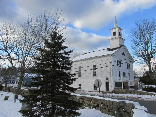
  6. 1790BuiltApponegansett Meeting House is built
  7. 19th century
  8. 1804Born hereHenry H. Crapo is born here
  9. 1810Post officeThe Dartmouth post office opens
  10. 1826Post officeThe North Dartmouth post office opens
  11. 1830Born hereWilliam W. Crapo is born here
  12. 1833Post officeThe South Dartmouth post office opens
  13. 1854Born hereBenjamin Tucker is born here
  14. 1888On the mapFirst mapped by the U.S. Geological Survey
  15. 20th century
  16. 1907In the archiveStreetcar and ledge in Dartmouth - postcard
  17. 1926Post officeThe South Dartmouth post office closes
  18. 1931Post officeThe North Dartmouth post office closes
  19. 1940In the archiveLand Utilization Town of Dartmouth - DPLA - e0017e961622d8734c9739481b28da74
  20. 1991Born hereChris Tsonis is born here
By decade

Dartmouth, decade by decade

3 decades in the archive, from the 1650s to the 1940s. Scroll each row; tap a photo for its story.

1910s–1930snothing yet
Nothing in the archives for these yearsWeddings on Main Street, storms, parades, school pictures, the old store. If it’s in your family album, it belongs here.
Add from your album
1950s–1990snothing yet
Nothing in the archives for these yearsWeddings on Main Street, storms, parades, school pictures, the old store. If it’s in your family album, it belongs here.
Add from your album
On the map

Dartmouth on the map, 1888 to 1893

Every edition of the U.S. Geological Survey’s map of Dartmouth. Tap a year, or press play to watch the town change.

Dartmouth on the 1888 USGS mapDartmouth on the 1893 USGS map1888Fall River sheet · 1:62,500

U.S. Geological Survey historical topographic maps (public domain), via Esri’s collection of the scans. The red ring marks the center of Dartmouth.

Every building

Dartmouth, building by building, 1924

Fire insurance maps drew every building, what it was made of and what it was used for, so insurers could price the risk of fire. Pick a sheet.

Dartmouth fire insurance map, 1924, sheet 11924Sheet 1 of 10

Sanborn Map Company, via the Library of Congress. Editions published in 1930 or earlier, which are in the public domain.

Then & now

Stand where they stood

No then-and-now pairs yet. Take a photo from the same spot as an old one and they appear here side by side.

Streetcar and ledge in Dartmouth - postcard
Retake this viewStreetcar and ledge in Dartmouth - postcard, 1907–1915

Find the spot, match the angle, and add your photo. It becomes the first then-and-now pair on Dartmouth’s page.

Retake this view · +15
People over time

Dartmouth, census by census

05,00010,00015,00020,00025,00030,00035,00018001850190019502000Peak: 34,032

Between 2,499 and 34,032 people in every census since 1790.

19 censuses, 1790–2020.

U.S. Census Bureau decennial counts, from the census table on Dartmouth’s Wikipedia page.

Famous people

10 famous people were born in Dartmouth

Writers, athletes, leaders and more, ranked by how widely they’re known.

See all →
Stories next door

History across the town line

Each neighbor’s History grade, on the same three inputs.

Questions about Dartmouth’s history

What year was Dartmouth founded?

In 1650, according to Wikidata. Dartmouth’s post office opened in 1810, and the first U.S. census counted 2,499 people here in 1790.

How does Dartmouth rank for history?

Dartmouth is more historic than 92% of U.S. towns, #129 of 283 in Massachusetts. The History grade combines the town’s founding era, the share of homes built before 1940 and its National Register listings. It’s a character grade, so it isn’t part of the overall grade. How it works.

What is on the National Register in Dartmouth?

7 listings: 2 buildings, among them the Hill School (listed 1980, the first), 4 historic districts with 212 contributing buildings, and 1 site. 216 historic buildings in all.

How old are the homes in Dartmouth?

18% of Dartmouth’s homes were built before 1940 (Census estimate, ±2.9 points), against a typical 21% for a Massachusetts town; the median home was built in 1973.

Memory lane

What the archives can’t tell you, neighbors can.

Town Square →
Start a conversation
Sources

Where this page comes from

Founding dates: Wikidata, Wikipedia, the U.S. post office records of Blevins & Helbock (CC0) and the Census. Homes by year built: Census ACS 2020–24. National Register of Historic Places: National Park Service (list of May 22, 2026). Old photos, postcards and papers: Wikimedia Commons, the Library of Congress and other public archives, credited on each item’s page. Maps: U.S. Geological Survey historical topographic maps (via Esri) and Sanborn fire-insurance maps (Library of Congress). History text and census tables: Wikipedia (CC BY-SA 4.0). Places that used to be: USGS Geographic Names Information System (2021).

From Wikimedia Commons (7), Wikidata (3), the National Register of Historic Places (7), Wikipedia, Wikidata and Wikipedia for famous people, U.S. Geological Survey historical maps, U.S. Census counts (via Wikipedia), the US Post Offices dataset (Blevins & Helbock), the USGS Geographic Names Information System, Sanborn fire insurance maps (Library of Congress) and old county and town histories (Internet Archive). Archive images are copied here with their credits and licenses, shown on each photo’s page. Refreshed monthly.