Plainfield’s post office opened in 1835, and 4 of its places are on the National Register
More historic than 68% of U.S. towns · #302 of 593 in Indiana. What drives it
Most of Plainfield was built recently: 3% of its homes predate 1940 and the median home dates from 2000. 4 places in town are on the National Register, among them a historic district with 174 buildings. Below: 2 old photos and papers, maps from 1886 on, and the census since 1850.
Founding year: the first Plainfield post office (Blevins & Helbock, CC0). Wikidata: 1839.The full story ↓
History grade
What drives Plainfield’s History grade
On its age, its old homes and the National Register, Plainfield is more historic than 68% of U.S. towns, #302 of 593 in Indiana. Its National Register listings hold the grade up; its share of homes from before 1940 pulls it down.
B+
HistoryA character grade: shown, never part of Plainfield’s overall grade.
Indiana towns list more on the Register than most of the country (a typical Indiana town has 7.9 per 10,000 residents, the U.S. 2.4), so Plainfield’s 49.2 sits above most of its state (75% of Indiana towns have fewer) while its 179 historic buildings outnumber those of 93% of U.S. towns.
How sure. Graded on any two of the three inputs instead, the letter would range from C+ to A. The pre-1940 share (±0.8 points) is firm at this size. The founding year is the first post office, not a stated founding date; Wikidata’s 1839 falls in the same era, so the grade doesn’t depend on which one is used.
Founding year: the first post office (other dates in Quick answers). Homes: Census ACS 2020–24. National Register: National Park Service, May 2026 list; each listing counted once (boundary changes and added documentation belong to their listing), and a historic district counts its contributing buildings. How TownRatings grades history →
What stands out about Plainfield’s past
Read from the archive, the National Register and the record. The page puts what stands out first.
In 1822, a tract of land which included the area now known as Plainfield was obtained by Jeremiah Hadley of Preble County, Ohio. Ten years later he sold it to his son, Elias Hadley. Levi Jessup and Elias Hadley laid out the town in 1839. Plainfield was incorporated as a town in 1839. The town got its name from the early Friends (Quakers) who settled around the area and established several meetinghouses throughout the county, including the important Western Yearly Meeting of Friends in Plainfield. The Friends were "plain" people, and thus the name "Plainfield". The high school continues to honor the Quakers, using the name for the school's mascot.
Passages that mention Plainfield, cut from the printed page as they were published.
History of the town of Plainfield, Hampshire County, Mass., from its settlement to 1891, including a genealogical history of twenty three of the original settlers and their descendants, with anecdotes and sketches1891Read the page →
Read the text
field, since which time the town lines have remained unaltered. May 15, 1806, it was " voted unanimously to petition the General Court to set off the District of Plainfield from Cummington and incorporate it into a town." This was accordingly done June 15, 1807. So far as appears, districts had all the privileges of towns, except that they had no representative in General Court and were joined to some other town for the purpose of ob-
Text read by machine from the scan; it may contain errors.
The First Church of Christ in Plainfield, then Quinebaug plantations, was organized January 3. 1 705. The people of the town, which included Canterbury and Plainfield, had held religious services from time to time, since, the first settlers came, about 1650. sometimes meeting on the east of the Quinebaug-, sometimes on the west.
Text read by machine from the scan; it may contain errors.
The history of the towns of Plainfield, Roxbury and Fayston, Vermont1882 · page 729Read the page →
Read the text
Plainfield village is at theextreme northern part of the town, and as incorporated in 1867, includes a portion of the town of Marshfield. In 1812, it contained about a dozen families, in 1 88 r about 80.
Text read by machine from the scan; it may contain errors.
count of the troubles over the land. They asked for a township ten miles square, and one was granted them the same year ten miles cast 'and west and eight miles north and south. It comprised substantially all the land now included in the present town of Plainfield and the present town of Canterbury. The white inhabitants were scattered over a considerable portion of this tract.
Text read by machine from the scan; it may contain errors.
Scans and text from the Internet Archive. Books published in 1930 or earlier, which are in the public domain.
Timeline
Plainfield, 1835 to 2020
Woven from the archive, old maps, post office records, the National Register and the people born here.
Nothing in the archives for these yearsWeddings on Main Street, storms, parades, school pictures, the old store. If it’s in your family album, it belongs here.
Every edition of the U.S. Geological Survey’s map of Plainfield. Tap a year, or press play to watch the town change.
1953Plainfield sheet · 1:24,000
U.S. Geological Survey historical topographic maps (public domain), via Esri’s collection of the scans. The red ring marks the center of Plainfield.
Every building
Plainfield, building by building, 1886–1921
Fire insurance maps drew every building, what it was made of and what it was used for, so insurers could price the risk of fire. Pick a year, then a sheet.
1886Sheet 1 of 1
Edition
Sheets
BrickWoodStone
Sanborn Map Company, via the Library of Congress. Editions published in 1930 or earlier, which are in the public domain.
Then & now
Stand where they stood
No then-and-now pairs yet. Take a photo from the same spot as an old one and they appear here side by side.
Retake this viewCentral Academy (Plainfield, Indiana) Class Photo, 1880
Find the spot, match the angle, and add your photo. It becomes the first then-and-now pair on Plainfield’s page.
The Plainfield post office opened in 1835, the earliest record of the town by name (U.S. post office records). Wikidata gives 1839.
How does Plainfield rank for history?
Plainfield is more historic than 68% of U.S. towns, #302 of 593 in Indiana. The History grade combines the town’s founding era, the share of homes built before 1940 and its National Register listings. It’s a character grade, so it isn’t part of the overall grade. How it works.
What is on the National Register in Plainfield?
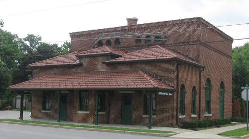
4 listings: 2 buildings, among them the Sugar Grove Meetinghouse and Cemetery (listed 2000, the first), 1 historic district, the Plainfield Historic District, with 174 contributing buildings, and 1 structure. 179 historic buildings in all.
How old are the homes in Plainfield?
3% of Plainfield’s homes were built before 1940 (Census estimate), against a typical 14% for an Indiana town; the median home was built in 2000.
Founding dates: Wikidata, Wikipedia, the U.S. post office records of Blevins & Helbock (CC0) and the Census. Homes by year built: Census ACS 2020–24. National Register of Historic Places: National Park Service (list of May 22, 2026). Old photos, postcards and papers: Wikimedia Commons, the Library of Congress and other public archives, credited on each item’s page. Maps: U.S. Geological Survey historical topographic maps (via Esri) and Sanborn fire-insurance maps (Library of Congress). History text and census tables: Wikipedia (CC BY-SA 4.0). Places that used to be: USGS Geographic Names Information System (2021).
From Wikimedia Commons (6), the National Register of Historic Places (4), Wikipedia, Wikidata and Wikipedia for famous people, U.S. Geological Survey historical maps, U.S. Census counts (via Wikipedia), the US Post Offices dataset (Blevins & Helbock), the USGS Geographic Names Information System, Sanborn fire insurance maps (Library of Congress) and old county and town histories (Internet Archive). Archive images are copied here with their credits and licenses, shown on each photo’s page. Refreshed monthly.



 2008
 2007
 2007
 2005


