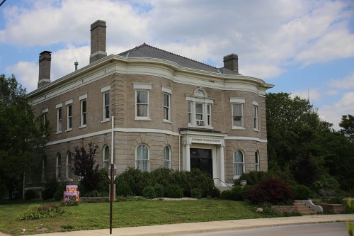
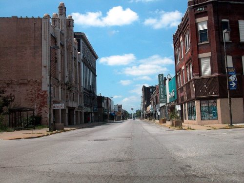
East St. Louis dates to 1797, and 28% of its homes were built before 1940
More historic than 93% of U.S. towns · #47 of 768 in Illinois. What drives it
8 places in town are on the National Register, among them two historic districts with 27 buildings between them. Below: 5 old photos and papers, maps from 1934 on, and the census since 1870.
Founding year: Wikipedia. First post office: 1824.The full story ↓
History grade
What drives East St. Louis’ History grade
On its age, its old homes and the National Register, East St. Louis is more historic than 93% of U.S. towns, #47 of 768 in Illinois. All 3 inputs are above most U.S. towns; its National Register listings ranks highest and its age lowest.
A
HistoryA character grade: shown, never part of East St. Louis’ overall grade.
Few Illinois towns list much on the Register (a typical Illinois town has 0.5 per 10,000 residents, the U.S. 2.4), so East St. Louis’ 17.8 sits above most of its state (86% of Illinois towns have fewer) while its 32 historic buildings outnumber those of 82% of U.S. towns.
How sure. Graded on any two of the three inputs instead, the letter would still be A. The pre-1940 share is a Census survey estimate (±4.1 points). Two sources give 1797.
Founding year: Wikipedia (other dates in Quick answers). Homes: Census ACS 2020–24. National Register: National Park Service, May 2026 list; each listing counted once (boundary changes and added documentation belong to their listing), and a historic district counts its contributing buildings. How TownRatings grades history →
What stands out about East St. Louis’ past
Read from the archive, the National Register and the record. The page puts what stands out first.
Lost post offices, old corners and places now gone
Two other post offices opened and closed inside today’s town.
Illinoistown
1824–1864
Chowning
1853–1857
East Saint Louis
1864–today
18201920today
Hamlets and corners on the map
East Saint LouisEdgemontHilltopRose Lake
Gone or out of use
Carver SchoolschoolCentral High SchoolschoolFranklin SchoolschoolGarfield SchoolschoolHughes-Quinn Junior High SchoolschoolJames Weldon Johnson SchoolschoolKenneth Hall Regional HospitalhospitalMartin Van Lucas SchoolschoolSaint Henrys ChurchchurchSaint Marys Roman Catholic ChurchchurchSaint Marys SchoolschoolWashington SchoolschoolWebster Annex SchoolschoolWebster SchoolschoolWinstanley Temple Church of God in Christchurch
US Post Offices dataset (Blevins & Helbock, CC0). Places and cemeteries from the USGS Geographic Names Information System (2021).
Famous people
53 famous people were born in East St. Louis
Writers, athletes, leaders and more, ranked by how widely they’re known.
Native Americans had long inhabited both sides of the Mississippi River. The Mississippian culture rulers organized thousands of workers to construct complex earthwork mounds at what later became St. Louis and East St. Louis. The center of this culture was the urban complex of Cahokia, located to the northeast of present-day East St. Louis within Collinsville, Illinois. Before the Civil War, settlers reported up to 50 mounds in the area that became East St. Louis, but most were lost to 19th-century development and later roadbuilding.
Passages that mention East St. Louis, cut from the printed page as they were published.
Centennial, McKendree college, with St. Clair County history1928Read the page →
Read the text
CONRAD REEB eROMINENT among the men in the business life of the city of East St. Louis and the surrounding district who have worked their way in the strength of personal merit and sheer ability, from stations of comparative obscurity to positions of influence is Conrad Reeb, who is president of the Southern Illinois National Bank and of the Southern Illinois Trust Company, both of East St. Louis. Mr.
Text read by machine from the scan; it may contain errors.
Centennial, McKendree college, with St. Clair County history1928Read the page →
Read the text
In 1906 when the Missouri Pacific railroad company located its shops at a point seven miles south of East St. Louis in the American Bottom, it laid the foundation of a thriving town called Dupo. The name is probably an abridgement of the name Prairie Du Pont which was anciently given to a settlement a short distance north of where Dupo now stands.
Text read by machine from the scan; it may contain errors.
History of St. Clair County, Illinois. With illustrations ... and biographical sketches of some of its prominent men and pioneers1881 · page 34Read the page →
Read the text
of this road in St. Clair county is ten miles, 3,690 feet, and in July, 1868, trains were first run between East St. Louis and Highland, and in July of the following year the road was completed from East St. Louis to Effingham, ninety-eight miles, and a through train service established between East St. Louis, and Chicago in connection with the Illinois Central Railroad, and in July, 1870, the last rails were laid between Effingham and the Indiana State line. Immediately thereafter a through line of sleeping cars was es-
Text read by machine from the scan; it may contain errors.
History of St. Clair County, Illinois. With illustrations ... and biographical sketches of some of its prominent men and pioneers1881 · page 300Read the page →
Read the text
The outline of the city of East St. Louis is in the form of an irregular pentagon, and acquired its present limits in time and manner as follows : Illinoistown was laid out by McKnight and Brady, May 14, 1818. Rsavis, in his history of "The Future Great City," places the date as 1817 ; but the records at Belleville show that the former is the correct date. Illinois City was formerly a part of the Cahokia Commons, and was laid out by the Cahokians in the fall of 1818. John Hays, John Hay, and Francois Turcott
Text read by machine from the scan; it may contain errors.
Scans and text from the Internet Archive. Books published in 1930 or earlier, which are in the public domain.
Timeline
East St. Louis, 1797 to 1984
Woven from the archive, old maps, post office records, the National Register and the people born here.
Nothing in the archives for these yearsWeddings on Main Street, storms, parades, school pictures, the old store. If it’s in your family album, it belongs here.
Nothing in the archives for these yearsWeddings on Main Street, storms, parades, school pictures, the old store. If it’s in your family album, it belongs here.
Every edition of the U.S. Geological Survey’s map of East St. Louis. Tap a year, or press play to watch the town change.
1934Cahokia sheet · 1:24,000
U.S. Geological Survey historical topographic maps (public domain), via Esri’s collection of the scans. The red ring marks the center of East St. Louis.
Then & now
Stand where they stood
No then-and-now pairs yet. Take a photo from the same spot as an old one and they appear here side by side.
Retake this view"St. Louis, Missouri.-Drawn by Schell and Hogan, from a Sketch by C. A. Vanderhoof.", 1876
Find the spot, match the angle, and add your photo. It becomes the first then-and-now pair on East St. Louis’ page.
In 1797, according to Wikipedia’s history of the town. East St. Louis’ post office opened in 1824, and the census of 1870 counted 5,044 people here.
How does East St. Louis rank for history?
East St. Louis is more historic than 93% of U.S. towns, #47 of 768 in Illinois. The History grade combines the town’s founding era, the share of homes built before 1940 and its National Register listings. It’s a character grade, so it isn’t part of the overall grade. How it works.
What is on the National Register in East St. Louis?
8 listings: 5 buildings and 2 historic districts, the Pennsylvania Avenue Historic District and the Downtown East St. Louis Historic District, with 27 contributing buildings. 32 historic buildings in all.
How old are the homes in East St. Louis?
28% of East St. Louis’ homes were built before 1940 (Census estimate, ±4.1 points), against a typical 11% for an Illinois town; the median home was built in 1956.
Founding dates: Wikidata, Wikipedia, the U.S. post office records of Blevins & Helbock (CC0) and the Census. Homes by year built: Census ACS 2020–24. National Register of Historic Places: National Park Service (list of May 22, 2026). Old photos, postcards and papers: Wikimedia Commons, the Library of Congress and other public archives, credited on each item’s page. Maps: U.S. Geological Survey historical topographic maps (via Esri) and Sanborn fire-insurance maps (Library of Congress). History text and census tables: Wikipedia (CC BY-SA 4.0). Places that used to be: USGS Geographic Names Information System (2021).
From Wikimedia Commons (5), Wikidata (1), the National Register of Historic Places (7), Wikipedia, Wikidata and Wikipedia for famous people, U.S. Geological Survey historical maps, U.S. Census counts (via Wikipedia), the US Post Offices dataset (Blevins & Helbock), the USGS Geographic Names Information System and old county and town histories (Internet Archive). Archive images are copied here with their credits and licenses, shown on each photo’s page. Refreshed monthly.


 1886