Founding year: the first Lindale post office (Blevins & Helbock, CC0).The full story ↓
History grade
What drives Lindale’s History grade
On its age, its old homes and the National Register, Lindale is more historic than 45% of U.S. towns, #126 of 263 in Georgia. Its share of homes from before 1940 holds the grade up; its age pulls it down.
B−
HistoryA character grade: shown, never part of Lindale’s overall grade.
Georgia towns list more on the Register than most of the country (a typical Georgia town has 10.0 per 10,000 residents, the U.S. 2.4), so Lindale’s 2.3 sits near the middle of its state (39% of Georgia towns have fewer) while its 1 listings outnumber those of 51% of U.S. towns.
How sure. Graded on any two of the three inputs instead, the letter would range from C to B−. The pre-1940 share is a Census survey estimate (±6.8 points). The founding year is the first post office, not a stated founding date.
Founding year: the first post office (other dates in Quick answers). Homes: Census ACS 2020–24. National Register: National Park Service, May 2026 list; each listing counted once (boundary changes and added documentation belong to their listing), and a historic district counts its contributing buildings. How TownRatings grades history →
A post office called Lindale has been in operation since 1883. The name Lindale might have been selected from a novel a resident had read.
Throughout the 20th century, the community formed around the Lindale Textile Mill located in the center of the community. Since the early part of the 21st century, the building is abandoned. The Mill was owned by the West Point-Pepperell for the majority of its existence, leading to the Lindale community to be commonly referred to as "Pepperell".
The local schools, which are part of the Floyd County School System, are named after the mill and use the West Point-Pepperell (currently WestPoint Home) Gryphon as the mascot, under the name "Pepperell Dragons".
Passages that mention Lindale, cut from the printed page as they were published.
A history of Rome and Floyd County, State of Georgia, United States of America1922 · page 354Read the page →
Read the text
From the top, the Lindale Inn; the Auditorium, erected by the Massachusetts Mills of Georgia in honor of Lindale's sacrifices in the World War; the old Hoss mill, now deserted; beautiful Silver Creek, which divides Lindale in half and flows through the mill property, shown in the next; homes of mill employes, who are encouraged in every way to develop better citizenship.
Text read by machine from the scan; it may contain errors.
A history of Rome and Floyd County, State of Georgia, United States of America1922 · page 302Read the page →
Read the text
dens in the neighboring county of Bartow. On a ridge about a mile north of Silver Creek Station, Southern railway, near Lindale, is a residence built like they used to build them: cement walls two feet thick, rooms approximately 50 feet square, including reception and ball rooms, and a barn
Text read by machine from the scan; it may contain errors.
Scans and text from the Internet Archive. Books published in 1930 or earlier, which are in the public domain.
Timeline
Lindale, 1883 to 1968
Woven from the archive, old maps, post office records, the National Register and the people born here.
Nothing in the archives for these yearsWeddings on Main Street, storms, parades, school pictures, the old store. If it’s in your family album, it belongs here.
The Lindale post office opened in 1883, the earliest record of the town by name (U.S. post office records).
How does Lindale rank for history?
Lindale is more historic than 45% of U.S. towns, #126 of 263 in Georgia. The History grade combines the town’s founding era, the share of homes built before 1940 and its National Register listings. It’s a character grade, so it isn’t part of the overall grade. How it works.
What is on the National Register in Lindale?
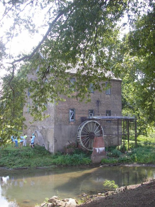
One place: the Old Brick Mill (listed 1993).
How old are the homes in Lindale?
15% of Lindale’s homes were built before 1940 (Census estimate, ±6.8 points), against a typical 3.8% for a Georgia town; the median home was built in 1965.
Founding dates: Wikidata, Wikipedia, the U.S. post office records of Blevins & Helbock (CC0) and the Census. Homes by year built: Census ACS 2020–24. National Register of Historic Places: National Park Service (list of May 22, 2026). Old photos, postcards and papers: Wikimedia Commons, the Library of Congress and other public archives, credited on each item’s page. Maps: U.S. Geological Survey historical topographic maps (via Esri) and Sanborn fire-insurance maps (Library of Congress). History text and census tables: Wikipedia (CC BY-SA 4.0). Places that used to be: USGS Geographic Names Information System (2021).
From Wikimedia Commons (3), the Library of Congress (3), the National Register of Historic Places (1), Wikipedia, Wikidata and Wikipedia for famous people, U.S. Geological Survey historical maps, U.S. Census counts (via Wikipedia), the US Post Offices dataset (Blevins & Helbock), the USGS Geographic Names Information System and old county and town histories (Internet Archive). Archive images are copied here with their credits and licenses, shown on each photo’s page. Refreshed monthly.


 1913
 1913
 1913
 1913