Plenty in its favour, and one clear drawback. With a B overall, Merritt Island is better than 55% of U.S. towns and ranks 125th of 634 in Florida. Its strongest is schools (B+) — its schools rank ahead of 74% of Florida towns. Health is a strength too: residents are healthier than 72% of U.S. towns on CDC estimates. What counts against it is cost of living (C−): the typical home is worth about $430K, 5.5 years of the Palm Bay metro’s $78K median household income. It also trails on hazard risk — FEMA rates its natural-hazard risk higher than 86% of U.S. communities, with hurricanes at the top. This Florida town has 2 places on the National Register of Historic Places, among them Dr. George E. Hill House and J.R. Field Homestead.
Figures: schools, state test and graduation results · health, CDC PLACES · home values, Zillow · incomes, Census ACS, 2020–24 · FEMA National Risk Index · National Register of Historic Places.
Expected losses in Merritt Island break down as 77% from hurricanes and 14% from inland flooding. 213 flood insurance claims have been paid here since 1978. Federal disaster aid has reached households in Merritt Island after 11 declared disasters, most recently in 2024.
Its public schools are run by the Brevard school district. Three of its 8 schools are shown below, with the reason for each. Public school enrollment in Merritt Island: 2,963 students across 6 schools.
The share of residents in Merritt Island who live below the poverty line: 7.4%. Only a tenth of working residents stay in Merritt Island for work; the rest commute out. 19% of workers do their job from home in the town, above both the Florida town median (14%) and the median of U.S. towns (11%). The town’s middle household income comes in at $94,000.
10%work in town
Merritt Island
Florida towns
U.S. towns
Work from home
19%
14%
11%
Median household income
$94,000
$73,000
$80,000
Below the poverty line
7.4%
11%
9.6%
Working residents who work in town
10%
5%
8%
Where working residents work
In Merritt Island10%
Melbourne7%
Palm Bay6%
Cocoa Beach5%
Orlando5%
17 mi
median commute distance
9,715
jobs based in Merritt Island
A commuter town
jobs vs. working residents
B
Walkability grade: more walkable than 59% of U.S. towns
Its widest gap with Florida is no health insurance: 9.1% of those 18–64 have no health insurance, against 15.9% statewide.
Nearly two in five adults have high blood pressure in Merritt Island, above both Florida’s towns (37%) and U.S. towns (35%). Merritt Island: nearly a third of adults sleep under 7 hours. On the CDC’s 31 measures, Merritt Island is ahead of Florida on 13 and behind on 2. Two figures for adults locally: 15% report frequent mental distress, 19% have been diagnosed with depression.
There are 14 miles of trail across 10 parks and preserves. Ulumay Sanctuary, at 716 acres with 2.6 miles of trail, is the biggest park or preserve. Parks and preserves in Merritt Island: 10, covering 899 acres.
January nights average 53.3°, milder than in 99% of U.S. towns; July afternoons average 89.6°. The Melbourne Wfo weather station, 14 miles away, records that about 76 days a year reach 90°: more than most of the country, but fewer than 89% of Florida places with climate records.
Its January low comes in at 53°F. It almost never snows.
Merritt Island’s age of the median resident is 50.2 years. People 65 and older are 28% of residents (21% statewide); adults 18 to 34 are 16% of residents (21% statewide). Just over two in five adults 25 and older hold a bachelor’s degree or more in the town.
50.2median age · FL 42.6
Merritt Island
Florida towns
U.S. towns
Median age
50.2 years
42.4 years
40.5 years
Aged 65 or older
28%
20%
18%
Under 18
17%
20%
22%
Bachelor’s degree or more, 25+
41%
31%
29%
Merritt IslandFloridaUnited States
Ages · share of residents
16%
<1010–1718–2425–3435–4445–5455–6465–7475+
Education · adults 25 and older
No diploma5%
High school21%
Some college21%
Associate’s12%
Bachelor’s24%
Graduate17%
Women and men · all residents
50% women, 50% men
WomenFLU.S.Men
That’s an even split within the survey’s margin of ±1.6 points. Across Florida, 50.9% of residents are women. Median age: women 51.9, men 48.9.
Homes in Merritt Island are typically worth about $430,000, up 0.8% in a year, 15% above the Florida typical home. Among households here, 80% own their home. On the market in the town: a median 62 days to sell.
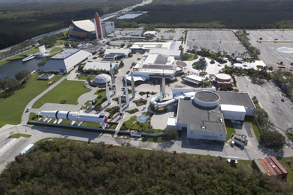
Merritt Island is a peninsula in Brevard County, Florida, United States, located on the eastern Florida coast, along the Atlantic Ocean. It is also the name of an unincorporated town in the central and southern parts of the island and a census-designated place (CDP). The population was 34,518 at the 2020 census, down from 34,743 at the 2010 census. It is part of the Palm Bay–Melbourne–Titusville, Florida Metropolitan Statistical Area. NASA's John F. Kennedy Space Center is located on Merritt Island to the north of the town, and Merritt Island National Wildlife Refuge is located north of the space center. The central part of Merritt Island, previously known as Merritt City, is home to the ma…
Merritt Island, Cocoa Beach, South Patrick Shores, North Merritt Island, Rockledge and Melbourne report no FBI crime data of their own. Compare Merritt Island with a neighbor →
Questions about Merritt Island
Short answers, built from the data on this page.
Is Merritt Island, FL a good place to live?
For most people who can afford it, yes. Merritt Island grades B overall, better than 55% of U.S. towns and #125 of 634 in Florida. It grades B+ for health and B+ for schools. Hazard risk is its weak spot, with a D.
Is Merritt Island, FL expensive?
Yes. Cost of living, which also weighs rents, property taxes and how many households pay 30% or more of their income for housing, grades C−.
What is Merritt Island, FL known for?
7 notable people were born here, including Keith Notary and Taylor Jordan.


 19 mi
 15 mi
 38 mi
 15 mi
 6 mi
 15 mi


