New Haven dates to 1638, and 40% of its homes were built before 1940
Among the most historic 1% of U.S. towns · #2 of 155 in Connecticut. What drives it
69 places in town are on the National Register, among them 9 National Historic Landmarks and ten historic districts with 6,321 buildings between them. Below: 23 old photos and papers, maps from 1886 on, and the census since 1790.
Founding year: Wikidata. First post office: 1773.The full story ↓
History grade
What drives New Haven’s History grade
On its age, its old homes and the National Register, New Haven is among the most historic 1% of U.S. towns, #2 of 155 in Connecticut. All 3 inputs put New Haven near the top nationally; its National Register listings ranks highest.
A+
HistoryA character grade: shown, never part of New Haven’s overall grade.
Among the 400 U.S. cities of 100,000 or more, New Haven ranks #5 on History.
Connecticut towns list more on the Register than most of the country (a typical Connecticut town has 73.3 per 10,000 residents, the U.S. 2.4), so New Haven’s 475 sits above most of its state (94% of Connecticut towns have fewer) while its 6,380 historic buildings outnumber those of 100% of U.S. towns.
NoteThe founding year comes from Wikidata alone; no second source gives 1638.
How sure. Graded on any two of the three inputs instead, the letter would still be A+. The pre-1940 share (±1.7 points) is firm at this size.
Founding year: Wikidata (other dates in Quick answers). Homes: Census ACS 2020–24. National Register: National Park Service, May 2026 list; each listing counted once (boundary changes and added documentation belong to their listing), and a historic district counts its contributing buildings. How TownRatings grades history →
What stands out about New Haven’s past
Read from the archive, the National Register and the record. The page puts what stands out first.
The country’s official list of buildings and places worth saving. 9 are National Historic Landmarks, the highest tier. Boundary changes and added documentation are counted with their listing.
Before Europeans arrived, the New Haven area was the home of the Quinnipiac tribe of Native Americans, who lived in villages around the harbor and sustained an economy of local fisheries and the farming of maize. The area was briefly visited by Dutch explorer Adriaen Block in 1614. Dutch traders set up a small trading system of beaver pelts with the local inhabitants, but trade was sporadic and the Dutch did not settle permanently in the area.
Passages that mention New Haven, cut from the printed page as they were published.
History of the colony of New Haven, before and after the union with Connecticut. Containing a particular description of the towns which composed that government, viz., New Haven, Milford, Guilford, Branford, Stamford, & Southold, L. I., with a notice of t1838 · page 99Read the page →
Read the text
that they might enjoy their religioys sentiments unmolested, they took an early opportunity to form themselves into a church, constituted according to their own peculiar views. It was organized, as already stated, at New Haven, at the same time with the church in that place, on the 22d of August, 1639. The method of forming their church was similar to that of New Haven. Seven persons were first chosen, who joined in covenant to be the church, and were called the seven
Text read by machine from the scan; it may contain errors.
History of the colony of New Haven to its absorption into Connecticut1902Read the page →
Read the text
of Christ, at New Haven, presented a writing, as before appears, whereby and wherewith he delivered up all his power and interest as a trustee by Mr. Hopkins, for recovering and bestowing of all that legacy given by him for the end of furtherance to the settlement of a college at New Haven ; he also propounded therewith, what he apprehends hath been granted and set apart by the town of New Haven for the same end, with a request that matters thereabouts might be ordered and carried on according to such proposi-
Text read by machine from the scan; it may contain errors.
History of the colony of New Haven to its absorption into Connecticut1902Read the page →
Read the text
6. That in the year 1644, the General Court for New Haven Colony, then sitting in the town of New Haven, agreed unanimously to send to England for a Patent, and in the year 1645, committed the procuring of it to Mr. Gregson, one of our magistrates, who entered upon his voyage in January that year from New Haven, furnished with some beaver in order thereunto as we suppose, but by the providence of God, the ship and all the passengers and goods were lost at sea in their passage toward
Text read by machine from the scan; it may contain errors.
Scans and text from the Internet Archive. Books published in 1930 or earlier, which are in the public domain.
By decade
New Haven, decade by decade
8 decades in the archive, from the 1840s to the 1930s. Scroll each row; tap a photo for its story.
Nothing in the archives for these yearsWeddings on Main Street, storms, parades, school pictures, the old store. If it’s in your family album, it belongs here.
Every edition of the U.S. Geological Survey’s map of New Haven. Tap a year, or press play to watch the town change.
1892New Haven sheet · 1:62,500
U.S. Geological Survey historical topographic maps (public domain), via Esri’s collection of the scans. The red ring marks the center of New Haven.
Every building
New Haven, building by building, 1886–1901
Fire insurance maps drew every building, what it was made of and what it was used for, so insurers could price the risk of fire. Pick a year, then a sheet.
Carver High SchoolschoolDavenport QuarterlocaleFort Nathan HalemilitaryFort WoostermilitaryFour CornerslocaleGoffe Street SchoolschoolGregson QuarterlocaleHertfordshire QuarterlocaleHughes FerrylocaleNew Haven StationlocaleNew Haven Veterans ColiseumbuildingOyster Point QuarterlocaleQuinnipiac Brewerylocale
14cemeteries and burying grounds inside New Haven
B'nail Jacob Memorial ParkCenter ChurchCityCongregation Mishkan IsraelEvergreenGrove StreetMapledaleMishkan IsraelNew Haven CryptSaint BernardsUnionWest River Memorial ParkWestvilleWoodin Street
US Post Offices dataset (Blevins & Helbock, CC0). Places and cemeteries from the USGS Geographic Names Information System (2021).
Help out
Finish New Haven’s story
Most archives stop around 1920. The photos from after that are in family albums, not libraries.
Decades since 1900 with photos
00s10s20s30s40s50s60s70s80s90s
3 of 10 decades. The empty ones are waiting for someone’s album.
In 1638, according to Wikidata. New Haven’s post office opened in 1773, and the first U.S. census counted 4,487 people here in 1790.
How does New Haven rank for history?
New Haven is among the most historic 1% of U.S. towns, #2 of 155 in Connecticut. The History grade combines the town’s founding era, the share of homes built before 1940 and its National Register listings. It’s a character grade, so it isn’t part of the overall grade. How it works.
What is on the National Register in New Haven?
69 listings, 9 of them National Historic Landmarks: 41 buildings, 22 historic districts with 6,321 contributing buildings, 2 sites, and 4 structures. 6,380 historic buildings in all.
How old are the homes in New Haven?
40% of New Haven’s homes were built before 1940 (Census estimate, ±1.7 points), against a typical 15% for a Connecticut town; the median home was built in 1954.
Founding dates: Wikidata, Wikipedia, the U.S. post office records of Blevins & Helbock (CC0) and the Census. Homes by year built: Census ACS 2020–24. National Register of Historic Places: National Park Service (list of May 22, 2026). Old photos, postcards and papers: Wikimedia Commons, the Library of Congress and other public archives, credited on each item’s page. Maps: U.S. Geological Survey historical topographic maps (via Esri) and Sanborn fire-insurance maps (Library of Congress). History text and census tables: Wikipedia (CC BY-SA 4.0). Places that used to be: USGS Geographic Names Information System (2021).
From Wikimedia Commons (23), Wikidata (7), the National Register of Historic Places (69), Wikipedia, Wikidata and Wikipedia for famous people, U.S. Geological Survey historical maps, U.S. Census counts (via Wikipedia), the US Post Offices dataset (Blevins & Helbock), the USGS Geographic Names Information System, Sanborn fire insurance maps (Library of Congress) and old county and town histories (Internet Archive). Archive images are copied here with their credits and licenses, shown on each photo’s page. Refreshed monthly.


 ★ Landmark
 ★ Landmark
 ★ Landmark
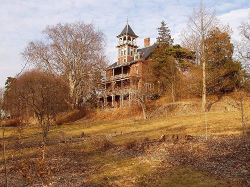 ★ Landmark
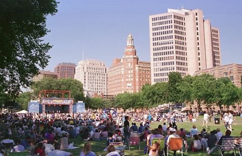 ★ Landmark
 ★ Landmark
 ★ Landmark
 ★ Landmark


 1859
 1888
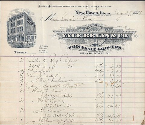 1888
 1901
 1901
 1901
 c. 1905
 c. 1905
 1906
 c. 1907
 1909
 1910
 c. 1913
 1915–1930
 c. 1930
 c. 1930
 c. 1930


