
Confederation ParkSaskatoon
The neighbourhood, home to 5,771 people, lies in Saskatoon. It is one of the 43 neighbourhoods that make up Saskatoon.
Is Confederation Park a good place to live?
One weak subject stands out against an otherwise good record. Households here earn well (A). At B overall, Confederation Park ranks #32 of 102 in Saskatchewan. Nationally, it does better than 58% of Canadian towns. It is strong on health as well (B+). The trade-off is safety (C−). Elsewhere it is close to typical: C+ for cost of living and B for walkability.
Rents here are the metro area's average, shared by every town and neighbourhood in it. Safety less sure: this is the whole city's figure, because the city doesn't publish open neighbourhood crime rates. No School Grade: this province doesn't publish comparable results school by school. Health is graded on the health region's survey figures and life expectancy, with the distance to hospital giving the town its own spread.
How Confederation Park grades
Each subject compares Confederation Park with Canadian towns of 2,500 or more, ordered by how far it is from the middle. Towns in other countries are graded separately.
How TownRatings grades Canadian towns →
What makes Confederation Park stand out
The 3 things Confederation Park does most differently from other towns.
The data
Data highlights are ordered by what stands out in Confederation Park.
Confederation Park’s grade for jobs & income: an A
Commutes averaged 20 min, between Saskatchewan’s towns (18 min) and Canadian towns (26 min).
How working residents got to work · census 2021
| Census 2021 | Confederation Park | Saskatchewan | Canada |
|---|---|---|---|
| Average trip | 20 min | 18 min | 26 min |
Statistics Canada, Census 2021 (labour and commuting) · Census day was in May 2021, mid-pandemic, so commuting and work figures carry the lockdowns’ mark.
Hazard risk in Confederation Park is lower than in 91% of Canadian towns
Radon tests for the Saskatoon RHA
Confederation Park’s survey area, 6.6% over the radon guideline, is close to the typical town’s 6.6%. Little of the land around Confederation Park has burned: 0.2% within 25 km since 1986, or 0.006% a year. No flood study for Confederation Park is on the national inventory. Figures for earthquake risk are published for the city of Saskatoon as a whole, not for Confederation Park alone.
Radon tests above the guideline · share of tested homes, 200 Bq/m³
| Hazards | Confederation Park | Saskatchewan | Canada |
|---|---|---|---|
| Radon tests above the guideline | 6.6% | 9.1% | 6.6% |
| Earthquake loss per $1,000 of buildings a year | $0.006 | $0.006 | $0.030 |
NRCan seismic risk model and burned areas, Health Canada radon survey, the Flood Hazard Map Inventory
Confederation Park’s grade for safety: a C−
The index for the force that serves it came to 119, about level with Saskatchewan’s towns (119) and above Canadian towns (67). For every 1,000 residents of its police area, 48.4 property crimes are reported each year. Violence across its police area runs at 15.2 per 1,000 residents a year.
Year by year · Crime Severity Index for each year
| 2023–2025 | Confederation Park | Saskatchewan | Canada |
|---|---|---|---|
| Crime Severity Index | 119 | 119 | 67 |
| Violent Crime Severity Index | 154 | 154 | 86 |
| Property crime per 1,000 | 48.4 | 48.4 | 31.2 |
Statistics Canada, Uniform Crime Reporting Survey, 2023–2025 average · Not measured by town: Crime Severity Index, Violent Crime Severity Index, violent crime and property crime per 1,000 (the Saskatoon service area)
49% of adults around Confederation Park rate their health very good or excellent
The survey counts 8.3% of adults as smokers, near Saskatchewan’s towns (8.6%) and lower than Canadian towns (12%). A baby born in the region can expect 81.4 years, 83.4 for a girl and 79.2 for a boy (2022/2024). The town’s own part is the trip to care: residents of Confederation Park live 3.4 km from a hospital on average, close to the typical town’s 3.7 km. Confederation Park doesn’t get its own health survey and life expectancy figures; the ones here come from the Saskatoon health region.
Very good or excellent health · adults, age-standardised
| Health | Confederation Park | Saskatchewan | Canada |
|---|---|---|---|
| Smokers | 8.3% | 8.6% | 12% |
| Life expectancy at birth | 81.4 | 80.2 | 81.5 |
| Very good or excellent health | 49% | 49% | 52% |
Statistics Canada, Canadian Community Health Survey 2023/2024 and life expectancy 2022/2024; Open Database of Healthcare Facilities
Few Canadian towns get less rain and snow than Confederation Park: 357 mm a year
A normal January night drops to −20.7°C, near Saskatchewan’s towns (−20.7°C) and lower than Canadian towns (−13.5°C). For the wettest month, look to June: 75 mm on average. January is the snowiest month, with 20 cm on average. Between the last spring frost, 19 May, and the first in autumn, 15 September, lie 117 days.
Average high by season · ECCC normals, 1991–2020
| Normals, 1991–2020 | Confederation Park | Saskatchewan | Canada |
|---|---|---|---|
| Precipitation a year | 357 mm | 383 mm | 883 mm |
| January night low | −20.7°C | −20.7°C | −13.5°C |
| Days with frost a year | 203 | 203 | 159 |
| Snowfall a year | 91 cm | 91 cm | 141 cm |
Environment and Climate Change Canada, Canadian Climate Normals 1991–2020 (Saskatoon Diefenbaker (Airport))
More households own their home in Confederation Park than in Saskatchewan’s towns or across Canadian towns: 80%
Shared with the rest of the Saskatoon metro area: rent as a share of income and monthly rent for a two-bedroom
Rent took a fifth of household income, about level with Canadian towns (20%) and above Saskatchewan’s towns (19%). Shelter took 30% or more of income for 17% of households, near Saskatchewan’s towns (17%) and lower than Canadian towns (18%).
What homes were worth · The median owner’s estimate at the 2021 census
| Census 2021 | Confederation Park | Saskatchewan | Canada |
|---|---|---|---|
| Households owning their home | 80% | 71% | 74% |
| Rent as a share of income | 20% | 19% | 20% |
Statistics Canada, Census 2021; CMHC Rental Market Survey via Statistics Canada · Home values are owners’ own estimates at the May 2021 census, and incomes are for 2020.
More of Confederation Park’s residents have an Indigenous identity than in Saskatchewan’s towns or Canadian towns: 18%
29% of residents belong to a visible minority, above Saskatchewan’s towns (16%) and Canadian towns (15%) alike.
Ages · Share of residents in each age group, Census 2021
Schooling · Highest qualification, residents 15 and over
Women and men · all residents
Women make up 50.2% of Confederation Park
2,885 women and 2,865 men at the 2021 census; across Canada, women are 50.9%.
| Confederation Park | Saskatchewan | Canada | |
|---|---|---|---|
| Under 15 | 19% | 18% | 16% |
| 15 to 64 | 70% | 65% | 64% |
| 65+ | 11% | 16% | 19% |
| No certificate, diploma or degree | 17% | 15% | 16% |
| Postsecondary qualification | 45% | 52% | 56% |
Statistics Canada, Census 2021; Saskatchewan and Canada: medians of towns of 2,500+
In Confederation Park, November normally means −1°C afternoons and −10°C nights
Snow is normal by November, about 13 cm over the month. Then December: −8°C by day, −18°C at night. Precipitation in November averages 14 mm. Also worth knowing: over the year, July is warmest at 25°C by day and January coldest at −21°C by night.
Normal highs, the months ahead · ECCC normals, 1991–2020
| Season | High | Low | Rain and snow |
|---|---|---|---|
| Winter | −9°C | −19°C | 35 mm |
| Spring | 9°C | −4°C | 79 mm |
| Summer | 24°C | 10°C | 176 mm |
| Autumn | 9°C | −3°C | 67 mm |
ECCC normals, 1991–2020 (Saskatoon Diefenbaker (Airport)); the forecast is on the Weather page
Turnout in Saskatoon West was just 56% in 2021, below 85% of ridings
City council runs Confederation Park, and Saskatoon’s mayor is Cynthia Block.
Wikidata, MAMH, MMAH, Statistics Canada
The nearest public library to Confederation Park is Mayfair Public Library, 2.5 km away
After it comes Library 20th st (Westmount), 3.9 km away.
Provincial library statistics, OpenStreetMap, the CRA and Statistics Canada
Fred Heal Canoe Launch, 16 km away, is the closest provincial park to Confederation Park
Of the country within 10 km, 1.2% lies in protected areas; the median Canadian town has 2.3%. Within 100 km there is no national park. The 10 km around town hold 14 protected areas. The largest is Sutherland Migratory Bird Sanctuary: 130 ha, 9.4 km from the edge of town.
Protected land · of the land within 10 km
| Outdoors | Confederation Park | Saskatchewan | Canada |
|---|---|---|---|
| Protected land within 10 km | 1.2% | 1.7% | 2.3% |
| Public protected areas within 10 km | 2 | 2 | 4 |
Canadian Protected and Conserved Areas Database (CPCAD), OpenStreetMap routes and beaches
Around Confederation Park, 24 elementary schools and 5 secondary schools: 29 schools in all
Counting each board with a school within 3 km gives 2, near Saskatchewan’s towns (2) and lower than Canadian towns (3).
| School | Level | Students | System |
|---|---|---|---|
| Bishop Roborecki Community SchoolIn Confederation ParkElementary | Elementary | – | English public |
| Tommy Douglas CollegiateNearest secondary school, 1 kmSecondary | Secondary | – | English public |
| Schools within 3 km | Confederation Park | Saskatchewan | Canada |
|---|---|---|---|
| School boards | 2 | 2 | 3 |
Statistics Canada’s Open Database of Educational Facilities · The schools grade is given only where results are open; in Saskatchewan, the province publishes no results school by school.
99% of Confederation Park’s homes date from 1961 or later
| Heritage | Confederation Park | Saskatchewan | Canada |
|---|---|---|---|
| Homes built before 1961 | 1% | 17% | 18% |
Canadian Register of Historic Places, Directory of Federal Heritage Designations, Québec’s Répertoire du patrimoine culturel, Wikidata; Census 2021 homes by period
Everything we know about Confederation Park
Cathedral of St. George and 14 more in and around Confederation Park
What there is to see in Confederation Park and within a short drive, starting with the places most people have heard of.
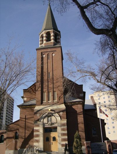
 CathedralCathedral of St. George2.6 km outside town, to the southeast
 CathedralSt. Paul's Cathedral4.6 km outside town, to the southeast
 Art galleryRemai Modern4.1 km outside town, to the southeast
 CathedralCathedral of St. John the Evangelist4.7 km outside town, to the southeast
 MuseumMusée Ukraina Museum2.6 km outside town, to the southeastWater parkWater parkRiversdale Pool3.5 km outside town, to the southeast
Photos: each place’s Wikidata image, from Wikimedia Commons under the licence below (our copy, resized).
Photo credits (5)
- Cathedral of St. George: Julia Adamson SriMesh talk, CC BY-SA 3.0, Wikimedia Commons
- St. Paul's Cathedral: Vic D, Public domain, Wikimedia Commons
- Remai Modern: Jmc881, CC BY-SA 3.0, Wikimedia Commons
- Cathedral of St. John the Evangelist: Jordon Cooper from Saskatoon, Canada, CC BY-SA 2.0, Wikimedia Commons
- Musée Ukraina Museum: Tanbir M-05, CC BY-SA 4.0, Wikimedia Commons
About Confederation Park
Neighbourhood in Saskatoon
The edges of Confederation Park follow census dissemination areas, which TownRatings groups into Saskatoon’s neighbourhoods; the name comes from the city’s map or OpenStreetMap.
Statistics Canada: population estimates 2025 (17-10-0155), Census of Population 2021, 2021 census boundaries.
- Population
- 5,771 (people, 2021 estimate)
- Province or territory
- Saskatchewan
- City
- Saskatoon
- Census subdivision
- 4711066
Confederation Park’s neighbours
The nearest places of 1,000 or more. Statistics Canada
| Town | People | km | Overall | Cost | Safety | Health |
|---|---|---|---|---|---|---|
| Confederation Park | 5,771 | — | B | C+ | C− | B+ |
| Pacific Heights | 3,770 | 0.6 | B− | C+ | C− | B+ |
| Dundonald | 2,855 | 0.9 | B+ | B+ | C− | B+ |
| Blairmore Suburban Centre | 7,411 | 1.1 | C+ | C− | C− | B+ |
| Massey Place | 6,561 | 1.4 | C− | D | C− | B+ |
| Fairhaven | 6,536 | 2 | C | D | C− | B+ |
| Parkridge | 4,518 | 2.2 | C+ | C+ | C− | B+ |
People: Statistics Canada, Census 2021. Distances: centre to centre.
Questions about Confederation Park
Is Confederation Park a young town or an old one?
Half its people are older than 37.9 (the middle of Canadian towns: 45.2); children under 15 make up 19%, people 65 and over 11%.
Sources: Statistics Canada, Census of Population 2021 · population estimates 2025 (17-10-0155) and 2021 census boundaries · Uniform Crime Reporting Survey 2023–25 (35-10-0026, 35-10-0183 to 35-10-0190) · CMHC rents as published by Statistics Canada (34-10-0133) · grades by TownRatings. Under the Statistics Canada Open Licence.
Adapted from Statistics Canada (Census of Population 2021, population estimates 2025, 2021 census boundaries) under the Statistics Canada Open Licence; this does not constitute an endorsement by Statistics Canada. Neighbourhood names in some cities © OpenStreetMap contributors (ODbL).