
 Top
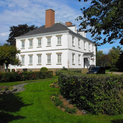
National Historic Site · 1799–1810Acacia Grove / Prescott House1633 Starr's Point RoadPhoto: Verne Equinox · CC BY 3.0 · Commons file
 Acacia Grove / Prescott House · Photo: Verne Equinox · CC BY 3.0
3historic places on the registers
History of Kings County, Subdivision B · Canada’s heritage registers
History in Kings County, Subdivision B goes back to 1799: Acacia Grove / Prescott House
On the registers Kings County, Subdivision B counts 3 historic places, 2 at the top. Relative to its size the figure is 2.4 per 10,000 residents, more than in 87% of Canadian towns. Designations here include a provincial or municipal listing. Wikidata knows 9 more provincial or municipal listings here that get no page, lacking an open statement or an encyclopedia article.
Historic places
3
2.4 per 10,000 residents
Highest designations
2
National Historic Sites and Classified Federal Heritage Buildings
Provincial and local listings
1
provincial and municipal listings with an encyclopedia article
Oldest building
1799
the first construction date on its record
Homes built before 1961
28%
typical town: 18%
In pictures
2 photos of Kings County, Subdivision B’s historic places
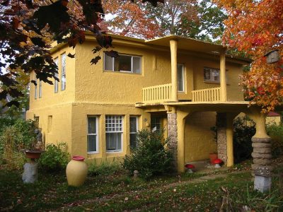
Up first are Acacia Grove / Prescott House and Charles Macdonald Concrete House Museum. 2 of the places on Kings County, Subdivision B’s heritage registers are pictured here; the others keep their register record. The set includes one of Kings County, Subdivision B’s most honoured places.
Photos from Wikimedia Commons, each credited to its photographer with its licence; names open the place’s page. Tap a photo to step through them full screen.
The map
Where Kings County, Subdivision B’s history is
Every place on the registers inside the town, by its designation.
Highest designationsProvincial and local listings
Names show on hover, and a tap takes you to the place’s page.
The 3, by tier
2 Highest designations1 Provincial and local listings
Parks Canada’s Directory of Federal Heritage Designations lists the places the Government of Canada has recognized; outside Québec, provincial and municipal listings come only through Wikidata, and only those with an encyclopedia article get a page.
Points from Wikidata (Parks Canada’s files carry none) and from Québec’s register, as mapped there.
Highest designations
2 places in Kings County, Subdivision B with the highest designation
They were designated between 1969 and 1990. National Historic Sites and Classified Federal Heritage Buildings, Canada’s highest federal recognition. Their dates run from 1799, with Acacia Grove / Prescott House, to 1864. Each one opens its own page.
National Historic Site · 1864–1903Sir Frederick Borden Residence9752 Main Street
Provincial and local listings
On a provincial or local list in Kings County, Subdivision B: one place
Provincial and municipal listings that Wikidata records and an encyclopedia describes. Each one opens its own page.
 Local
Provincially Registered Property · 1910Charles Macdonald Concrete House MuseumPhoto: Skinnzy · CC BY-SA 3.0 · Commons file
Homes by age
Old houses stand out in Kings County, Subdivision B: 28% predate 1961, where most towns have 18%
Homes built from 2016 to 2021 are 3.3% of Kings County, Subdivision B’s, about the typical 4.1%. The busiest building years in Kings County, Subdivision B were from 1981 to 2000, which account for 29% of today’s homes. Half of the homes standing in Kings County, Subdivision B today were built before 1981.
28%
Before 1961
25%
1961–80
29%
1981–2000
14%
2001–15
3.3%
2016–21
Kings County, Subdivision BTypical town
2021 Census, private dwellings by period of construction (Statistics Canada); the typical town is the middle Canadian town of 2,500 or more.
Born here
Born in Kings County, Subdivision B, 1835 to 1912
9 people on the record were born here before 1914. The widest known is Theodore Harding Rand: 5 Wikipedia editions. Of them all, Nathaniel Curry lived longest: 80 years, until 1931. 5 of the 9 were born in the years before Confederation.
Theodore Harding Rand
Frederick William Borden
Nathaniel Curry
James Everett Kinsman
Robie Lewis Reid
Ransford Dodsworth Bucknam
Harold Lothrop Borden
Frank Manning Covert
Victor N. Thorpe
1800182518501875190019251950

Theodore Harding Rand1835–1900 · Canadian educator, civil servant, and poet
FB
Frederick William Borden1847–1917 · Canadian politician
RR
Robie Lewis Reid1866–1945 · Canadian historian and numismatist

Harold Lothrop Borden1876–1900 · Canadian military officer

Nathaniel Curry1851–1931 · Canadian politician

Ransford Dodsworth Bucknam1869–1915 · Canadian-born admiral of the Ottoman Empire
FC
Frank Manning Covert1908–1987 · Canadian lawyer
JK
James Everett Kinsman1855–1924 · Canadian politician from Nova Scotia
Everyone born in Kings County, Subdivision B → Born before 1914 (the page’s periods: Confederation to the First World War). Birthplaces from Wikidata, each checked against the person’s Wikipedia article.
Towns its size
Kings County, Subdivision B has the 3rd most of 16 towns its size
Towns of 12,500 to 12,800 residents, by places on the registers.
Kings County, Subdivision B3
Just these have more: Amos and Carignan. Their median is 0. 10 of them have none.
Neighbours
Kings County, Subdivision B and its neighbours
| Town | People | Places | Highest | Oldest |
|---|---|---|---|---|
| Kings County, Subdivision B | 12,661 | 3 | 2 | 1799 |
| Kentville | 7,589 | 2 | 0 | 1912 |
| Wolfville | 5,587 | 2 | 1 | 1878 |
| Kings County, Subdivision C | 8,994 | 0 | 0 | — |
| Kings County, Subdivision D | 6,517 | 4 | 4 | 1680 |
In brief
Kings County, Subdivision B in brief
In Kings County, Subdivision B, 28% of homes were built before 1961, against 18% in the typical town. The lists come to 3 historic places, 2 with the highest designation. Of the 16 towns closest in size, just 2 have more historic places. Among the lives from its past: Theodore Harding Rand (1835), Frederick William Borden (1847) and Robie Lewis Reid (1866). Everything else is close to the norm: its places were designated between 1969 and 1990.
How to read these numbers
What this data can and can’t tell you
- The federal register. Every federal designation is in Parks Canada’s directory, and the Canadian Register of Historic Places gives most of them a bilingual statement of significance.
- Provincial and municipal lists. The local and provincial lists outside Québec aren’t published openly, so this page counts what Wikidata records and pages only the places an encyclopedia describes.
- Protection. Being on these registers doesn’t mean a building can’t change. Federal designation commemorates; protection is provincial or municipal, and those lists aren’t open here.
- Map points. Where a federal place sits on the map is Wikidata’s placing; the directory itself has no coordinates.
- People and events. Parks Canada’s open file gives its national historic persons no place. A town’s page names one only when the person was born there (matched by name and both life years) or one of its own historic places carries the name and its record speaks of them; national historic events stay off.
- The tiers. The highest designations are National Historic Sites, Classified Federal Heritage Buildings and Québec’s classements; then come the other federal designations; then provincial and local listings.
- The grade. This page gives no grade; history doesn’t count toward a Canadian town’s letter.
Questions about Kings County, Subdivision B’s history
What is the oldest building in Kings County, Subdivision B?
Acacia Grove / Prescott House — its record dates it to 1799 (National Historic Site).
Which places in Kings County, Subdivision B have the highest designation?
They are Acacia Grove / Prescott House and Sir Frederick Borden Residence.
How old are the homes in Kings County, Subdivision B?
The 2021 Census dates 28% of its homes before 1961 (18% in the typical town).
Why might a heritage building in Kings County, Subdivision B be missing here?
Its province’s and council’s own lists can’t be reused here; 9 further listings in Kings County, Subdivision B show up only as Wikidata numbers.
Contains information licensed under the Open Government Licence – Canada (Parks Canada).
Sources: Parks Canada, Directory of Federal Heritage Designations · Canadian Register of Historic Places (federal extract) · Wikidata (CC0) for map points, other names and articles · Statistics Canada, 2021 Census (homes by period of construction). Under the Statistics Canada Open Licence.
Adapted from Statistics Canada (Census of Population 2021, population estimates 2025, 2021 census boundaries) under the Statistics Canada Open Licence; this does not constitute an endorsement by Statistics Canada. Neighbourhood names in some cities © OpenStreetMap contributors (ODbL).