Oakland dates to 1852, and 37% of its homes were built before 1940
More historic than 85% of U.S. towns · #20 of 847 in California. What drives it
62 places in town are on the National Register, among them 5 National Historic Landmarks and four historic districts with 77 buildings between them. Below: 15 old photos and papers, maps from 1889 on, and the census since 1860.
Founding year: Wikidata. First post office: 1855.The full story ↓
History grade
What drives Oakland’s History grade
On its age, its old homes and the National Register, Oakland is more historic than 85% of U.S. towns, #20 of 847 in California. Its share of homes from before 1940 holds the grade up; its age pulls it down.
A−
HistoryA character grade: shown, never part of Oakland’s overall grade.
Among the 400 U.S. cities of 100,000 or more, Oakland ranks #99 on History.
Few California towns list much on the Register (a typical California town has 0.0 per 10,000 residents, the U.S. 2.4), so Oakland’s 3.3 sits above most of its state (85% of California towns have fewer) while its 144 historic buildings outnumber those of 91% of U.S. towns.
How sure. Graded on any two of the three inputs instead, the letter would range from B+ to A+. The pre-1940 share (±0.7 points) is firm at this size. Two sources give 1852.
Founding year: Wikidata (other dates in Quick answers). Homes: Census ACS 2020–24. National Register: National Park Service, May 2026 list; each listing counted once (boundary changes and added documentation belong to their listing), and a historic district counts its contributing buildings. How TownRatings grades history →
What stands out about Oakland’s past
Read from the archive, the National Register and the record. The page puts what stands out first.
Adeline Street StationlocaleBroadway StationlocaleCalifornia Concordia CollegeschoolCenter Street StationlocaleChrist Holy Sanctified ChurchchurchChurch of Our SaviourchurchCivic Center HospitalhospitalClinton StationlocaleDamon StationlocaleEast Oakland Community High SchoolschoolEast Oakland StationlocaleElisabeth Sherman Elementary SchoolschoolElmhurst StationlocaleEmbarcadero TemescallocaleFirst Lutheran ChurchchurchFranklin SquareparkGreek Orthodox Church of the AssumptionchurchHillside Academyschool
5cemeteries and burying grounds inside Oakland
EvergreenEvergreen MausoleumHome of PeaceMountain ViewSaint Marys
US Post Offices dataset (Blevins & Helbock, CC0). Places and cemeteries from the USGS Geographic Names Information System (2021).
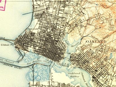
On the map
Oakland on the map, 1895 to 1993
Every edition of the U.S. Geological Survey’s map of Oakland. Tap a year, or press play to watch the town change.
1895San Francisco sheet · 1:62,500
U.S. Geological Survey historical topographic maps (public domain), via Esri’s collection of the scans. The red ring marks the center of Oakland.
The earliest known inhabitants of the area were the Huchiun natives, who lived there for thousands of years. The Huchiun belonged to a linguistic grouping later called the Ohlone (a Miwok word meaning "western people"). In Oakland, they were concentrated around Lake Merritt and Temescal Creek, a stream that enters the San Francisco Bay at Emeryville.
Passages that mention Oakland, cut from the printed page as they were published.
History of the state of California and biographical record of Oakland and environs, also containing biographies of well-known citizens of the past and present1907 · page 636Read the page →
Read the text
Later, in partnership with D. G. Barnes, he established one of the first planing mills in the then small town of Oakland. Finally he embarked in the wholesale tobacco business in partnership with two others, his work being soliciting and the management of the Oakland branch. He met with success in his efforts and continued so occupied up to the time of his death, which occurred
Text read by machine from the scan; it may contain errors.
History of the state of California and biographical record of Oakland and environs, also containing biographies of well-known citizens of the past and present1907 · page 629Read the page →
Read the text
which Mr. Emery has ever been engaged, from the standpoint of the public, is his connection with the great work of deepening the bay at the mouth of Oakland harbor. During the early years of Oakland's history the greatest drawback in tlie development of the city, from both a commercial standpoint and as a place of residence for persons whose business necessitated daily
Text read by machine from the scan; it may contain errors.
Scans and text from the Internet Archive. Books published in 1930 or earlier, which are in the public domain.
Timeline
Oakland, 1852 to 1951
Woven from the archive, old maps, post office records, the National Register and the people born here.
Nothing in the archives for these yearsWeddings on Main Street, storms, parades, school pictures, the old store. If it’s in your family album, it belongs here.
Fire insurance maps drew every building, what it was made of and what it was used for, so insurers could price the risk of fire. Pick a year, then a sheet.
In 1852, according to Wikidata. Oakland’s post office opened in 1855, and the census of 1860 counted 1,543 people here.
How does Oakland rank for history?
Oakland is more historic than 85% of U.S. towns, #20 of 847 in California. The History grade combines the town’s founding era, the share of homes built before 1940 and its National Register listings. It’s a character grade, so it isn’t part of the overall grade. How it works.
What is on the National Register in Oakland?
62 listings, 6 of them National Historic Landmarks: 54 buildings, among them the Abbey, The-Joaquin Miller House (a National Historic Landmark since 1962), 4 historic districts with 77 contributing buildings, 1 site, and 2 structures. 144 historic buildings in all.
How old are the homes in Oakland?
37% of Oakland’s homes were built before 1940 (Census estimate), against a typical 3.4% for a California town; the median home was built in 1953.
Founding dates: Wikidata, Wikipedia, the U.S. post office records of Blevins & Helbock (CC0) and the Census. Homes by year built: Census ACS 2020–24. National Register of Historic Places: National Park Service (list of May 22, 2026). Old photos, postcards and papers: Wikimedia Commons, the Library of Congress and other public archives, credited on each item’s page. Maps: U.S. Geological Survey historical topographic maps (via Esri) and Sanborn fire-insurance maps (Library of Congress). History text and census tables: Wikipedia (CC BY-SA 4.0). Places that used to be: USGS Geographic Names Information System (2021).
From Wikimedia Commons (9), the Library of Congress (6), Wikidata (7), the National Register of Historic Places (61), Wikipedia, Wikidata and Wikipedia for famous people, U.S. Geological Survey historical maps, U.S. Census counts (via Wikipedia), the US Post Offices dataset (Blevins & Helbock), the USGS Geographic Names Information System, Sanborn fire insurance maps (Library of Congress) and old county and town histories (Internet Archive). Archive images are copied here with their credits and licenses, shown on each photo’s page. Refreshed monthly.


 ★ Landmark
 ★ Landmark
 ★ Landmark
 ★ Landmark
 ★ Landmark


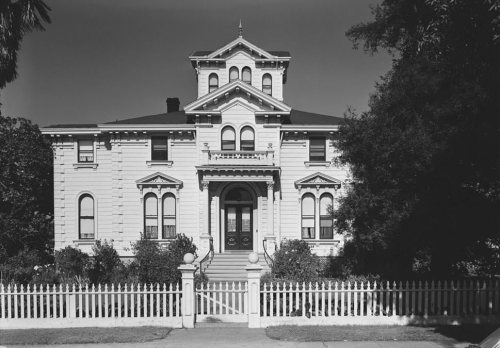




 1874
 1894
 1896
 1898
 1899
 1901
 1906
 1907
 1907
 1908


