Anniston dates to 1872, and 14% of its homes were built before 1940
More historic than 72% of U.S. towns · #35 of 187 in Alabama. What drives it
46 places in town are on the National Register, among them eight historic districts with 681 buildings between them. Below: 11 old photos and papers, maps from 1885 on, and the census since 1880.
Founding year: Wikidata. First post office: 1860.The full story ↓
History grade
What drives Anniston’s History grade
On its age, its old homes and the National Register, Anniston is more historic than 72% of U.S. towns, #35 of 187 in Alabama. Its National Register listings hold the grade up; its age pulls it down.
B+
HistoryA character grade: shown, never part of Anniston’s overall grade.
Alabama towns list about as much on the Register as the country (a typical Alabama town has 2.7 per 10,000 residents, the U.S. 2.4), so Anniston’s 341 sits above most of its state (93% of Alabama towns have fewer) while its 726 historic buildings outnumber those of 98% of U.S. towns.
How sure. Graded on any two of the three inputs instead, the letter would range from C+ to A. The pre-1940 share (±2.4 points) is firm at this size. Two sources give 1872.
Founding year: Wikidata (other dates in Quick answers). Homes: Census ACS 2020–24. National Register: National Park Service, May 2026 list; each listing counted once (boundary changes and added documentation belong to their listing), and a historic district counts its contributing buildings. How TownRatings grades history →
What stands out about Anniston’s past
Read from the archive, the National Register and the record. The page puts what stands out first.
National Park Service, National Register of Historic Places. Photos from Wikimedia Commons, credited on each place’s page.
Places that used to be
Lost post offices, old corners, places now gone and burying grounds
Anniston’s post office has been open since 1873. Four other post offices opened and closed inside today’s town.
Blue Mountain
1860–1871
Anniston
1873–today
Oxanna
1884–1902
Obed
1892–1907
Blue Mountain
1913–1960
18601940today
Hamlets and corners on the map
Blue MountainBlue SpringsGolden SpringsLardentLenlockLetchersObedOxannaPelham HeightsSherman HeightsSpring ValleyWoodland Park
Gone or out of use
Anniston College for Young LadiesschoolAnniston Negro SchoolschoolColdwater CamplocaleDark CornerslocaleNoble InstituteschoolPine Avenue Public SchoolschoolQuintard Avenue Public SchoolschoolSaint Lukes HospitalhospitalWilmer Avenue SchoolschoolZinn Hall Public Schoolschool
6cemeteries and burying grounds inside Anniston
EdgemontForestlawn GardensHighlandHillsidePrisoner of WarUnion Grove
US Post Offices dataset (Blevins & Helbock, CC0). Places and cemeteries from the USGS Geographic Names Information System (2021).
The first white settlers of the area were James Jefferson Teague and Martha Golden. They settled the area in 1828 near what would become known as Woodstock spring with other settlers soon arriving and building around Teague. By the Civil War, the Confederate States of America operated an iron furnace near present-day downtown, until it was destroyed by the Union Army in 1865.
In 1872 the Woodstock Iron Company, organized by Samuel Noble and Union Gen. Daniel Tyler, founded a larger-scale furnace on the same grounds. Anniston was chartered as a city in 1879 and opened to the public in 1883, named as a combination of Daniel's daughter-in-law Annie and -ton for iron ore.
Passages that mention Anniston, cut from the printed page as they were published.
Historical and statistical review and mailing and shipping guide of North Alabama (illustrated) embracing the cities of Birmingham, Anniston, Gadsden, Huntsville, Decatur, Tuscaloosa and Bessemer, with their manufacturing and mercantile industries ... and1888 · page 173Read the page →
Read the text
is that of "city building." In days of yore a city's growth could be likened to a complicated machine made by a hundred difi"erent workmen, each intent on his own plan, knowing not and caring not for the plans of the other ninetynine. To-day, as evidenced by the city of Anniston, the machine has a guiding hand which directs the plans of each workman and conforms them to one grand finished plan. The "city builders" of Anniston first selected the site for a great city, where Nature had, as it were, in a lavish mood, concentrated many of its grandest gifts. With keen foresight tliat saw a future now
Text read by machine from the scan; it may contain errors.
Historical and statistical review and mailing and shipping guide of North Alabama (illustrated) embracing the cities of Birmingham, Anniston, Gadsden, Huntsville, Decatur, Tuscaloosa and Bessemer, with their manufacturing and mercantile industries ... and1888 · page 181Read the page →
Read the text
Jt was but a few years ago when the machinery necessary for such a gigantic ;plant as this could only have been secured in the North or West, but now Anniston builds the machinery that is to run these great furnaces that will isoon be turning out iron at the rate of 100,000 tons a year. The thirty-six iDoilers and the five 900 horse-power engines are all the product of Anniston's ■works, and even the fire brick are produced in Anniston from the Anniston -clay. Some idea of the magnitude of this plant can be obtained from the fact that it will require five 900 horse-power engines, or a total of 4,500 horse-
Text read by machine from the scan; it may contain errors.
Scans and text from the Internet Archive. Books published in 1930 or earlier, which are in the public domain.
Timeline
Anniston, 1850 to 1956
Woven from the archive, old maps, post office records, the National Register and the people born here.
Nothing in the archives for these yearsWeddings on Main Street, storms, parades, school pictures, the old store. If it’s in your family album, it belongs here.
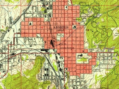
Every edition of the U.S. Geological Survey’s map of Anniston. Tap a year, or press play to watch the town change.
1947Anniston sheet · 1:24,000
U.S. Geological Survey historical topographic maps (public domain), via Esri’s collection of the scans. The red ring marks the center of Anniston.
Every building
Anniston, building by building, 1885–1925
Fire insurance maps drew every building, what it was made of and what it was used for, so insurers could price the risk of fire. Pick a year, then a sheet.
In 1872, according to Wikidata. Anniston’s post office opened in 1860, and the census of 1880 counted 942 people here.
How does Anniston rank for history?
Anniston is more historic than 72% of U.S. towns, #35 of 187 in Alabama. The History grade combines the town’s founding era, the share of homes built before 1940 and its National Register listings. It’s a character grade, so it isn’t part of the overall grade. How it works.
What is on the National Register in Anniston?
46 listings: 36 buildings, among them the Anniston Inn Kitchen (listed 1973, the first), 8 historic districts with 681 contributing buildings, 1 structure, and 1 object. 726 historic buildings in all.
How old are the homes in Anniston?
14% of Anniston’s homes were built before 1940 (Census estimate, ±2.4 points), against a typical 3.2% for an Alabama town; the median home was built in 1967.
Founding dates: Wikidata, Wikipedia, the U.S. post office records of Blevins & Helbock (CC0) and the Census. Homes by year built: Census ACS 2020–24. National Register of Historic Places: National Park Service (list of May 22, 2026). Old photos, postcards and papers: Wikimedia Commons, the Library of Congress and other public archives, credited on each item’s page. Maps: U.S. Geological Survey historical topographic maps (via Esri) and Sanborn fire-insurance maps (Library of Congress). History text and census tables: Wikipedia (CC BY-SA 4.0). Places that used to be: USGS Geographic Names Information System (2021).
From Wikimedia Commons (11), Wikidata (1), the National Register of Historic Places (46), Wikipedia, Wikidata and Wikipedia for famous people, U.S. Geological Survey historical maps, U.S. Census counts (via Wikipedia), the US Post Offices dataset (Blevins & Helbock), the USGS Geographic Names Information System, Sanborn fire insurance maps (Library of Congress) and old county and town histories (Internet Archive). Archive images are copied here with their credits and licenses, shown on each photo’s page. Refreshed monthly.





 1850
 1850
 1850
 1850
 c. 1869
 c. 1869
 c. 1869
 1891


