Guest, Sign inJoin

Post to Fort Gay

We’ll email a one-tap link to publish your post. No password, and nothing is public until you click it.
Already a member? Sign in
–Not graded
History · Fort Gay

Fort Gay dates to 1789, and 1 of its places is on the National Register

Most of Fort Gay was built recently: 8% of its homes predate 1940 and the median home dates from 1984. Its Register listing is the Fort Gay High School. Below: maps from 1939 on and the census since 1880.

1789founded
1on the National Register
8%homes built before 1940
Quick answers

How Fort Gay began

When was Fort Gay founded?

1789

Fort Gay dates its founding to 1789 (Wikidata). The census first counted it in 1880.

First census: 253 in 18802020 census: 675237 years
Founding year: Wikidata. First post office: 1855.The full story ↓

What stands out about Fort Gay’s past

Read from the archive, the National Register and the record. The page puts what stands out first.

★ What stands out · Help out

Start Fort Gay’s collection

The first neighbors to add old photos shape how Fort Gay’s history is told.

Decades since 1900 with photos
00s10s20s30s40s50s60s70s80s90s
0 of 10 decades. The empty ones are waiting for someone’s album.
Timeline

Fort Gay, 1789 to 1939

Woven from the archive, old maps, post office records, the National Register and the people born here.

  1. 18th century
  2. 1789
    FoundingFort Gay is established
  3. 19th century
  4. 1855Post officeThe Fort Gay post office opens
  5. 20th century
  6. 1939On the mapFirst mapped by the U.S. Geological Survey
The story

How Fort Gay came to be

From Wikipedia’s history of Fort Gay.

Read it all →

The Fort Gay community traces back to 1789, when 11 people established a settlement at the junction of the Tug and Big Sandy rivers, across from what is now Louisa, Kentucky. In 1875, it was chartered as Cassville; though it was simultaneously known as Fort Gay. In 1932, the town's name was officially changed to Fort Gay. Although there is no evidence as to why the name was changed, there are several prevalent theories: that either the railroad company or post office did not want two Cassvilles on the same route/state (there is another Cassville, West Virginia), or that a Civil War nurse named Gay became synonymous with the town.

Text from Wikipedia, licensed CC BY-SA 4.0.

By decade

Fort Gay, decade by decade

On the map

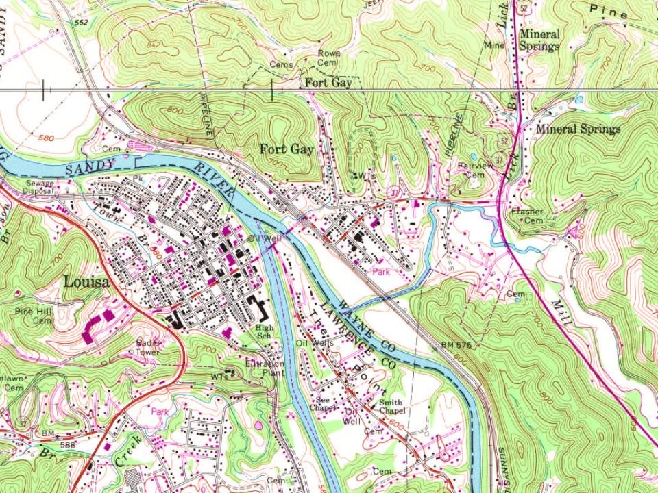
Fort Gay on the map, 1939 to 1993

Every edition of the U.S. Geological Survey’s map of Fort Gay. Tap a year, or press play to watch the town change.

Fort Gay on the 1939 USGS mapFort Gay on the 1953 USGS mapFort Gay on the 1962 USGS mapFort Gay on the 1971 USGS mapFort Gay on the 1989 USGS mapFort Gay on the 1993 USGS map1939Louisa sheet · 1:62,500

U.S. Geological Survey historical topographic maps (public domain), via Esri’s collection of the scans. The red ring marks the center of Fort Gay.

On the National Register

1 historic place in Fort Gay

The country’s official list of buildings and places worth saving.

place listed
1
National Historic Landmarks
0
none yet
historic buildings protected
1
each building in a district counts
first listed
2017
Fort Gay High School
All 1 listings

National Park Service, National Register of Historic Places. Photos from Wikimedia Commons, credited on each place’s page.

People over time

Fort Gay, census by census

020040060080018801900192019401960198020002020Peak: 886

Between 253 and 886 people in every census since 1880.

14 censuses, 1880–2020.

U.S. Census Bureau decennial counts, from the census table on Fort Gay’s Wikipedia page.

Famous people

Famous people close to Fort Gay

Nobody well known was born in Fort Gay itself, so here are the best known from just nearby.

See all →

Questions about Fort Gay’s history

What year was Fort Gay founded?

In 1789, according to Wikidata. Fort Gay’s post office opened in 1855, and the census of 1880 counted 253 people here.

What is on the National Register in Fort Gay?

One place: the Fort Gay High School (listed 2017).

Memory lane

What the archives can’t tell you, neighbors can.

Town Square →
Start a conversation
Sources

Where this page comes from

Founding dates: Wikidata, Wikipedia, the U.S. post office records of Blevins & Helbock (CC0) and the Census. Homes by year built: Census ACS 2020–24. National Register of Historic Places: National Park Service (list of May 22, 2026). Old photos, postcards and papers: Wikimedia Commons, the Library of Congress and other public archives, credited on each item’s page. Maps: U.S. Geological Survey historical topographic maps (via Esri) and Sanborn fire-insurance maps (Library of Congress). History text and census tables: Wikipedia (CC BY-SA 4.0). Places that used to be: USGS Geographic Names Information System (2021). How TownRatings grades history →

From Wikimedia Commons (2), the National Register of Historic Places (1), Wikipedia, U.S. Geological Survey historical maps, U.S. Census counts (via Wikipedia), the US Post Offices dataset (Blevins & Helbock) and the USGS Geographic Names Information System. Archive images are copied here with their credits and licenses, shown on each photo’s page. Refreshed monthly.