Clarksburg dates to 1785, and 40% of its homes were built before 1940
More historic than 96% of U.S. towns · #7 of 61 in West Virginia. What drives it
8 places in town are on the National Register, among them three historic districts with 283 buildings between them. Below: 12 old photos and papers, maps from 1884 on, and the census since 1860.
Founding year: Wikidata. First post office: 1797.The full story ↓
History grade
What drives Clarksburg’s History grade
On its age, its old homes and the National Register, Clarksburg is more historic than 96% of U.S. towns, #7 of 61 in West Virginia. All 3 inputs are above most U.S. towns; its share of homes from before 1940 ranks highest and its age lowest.
A+
HistoryA character grade: shown, never part of Clarksburg’s overall grade.
West Virginia towns list more on the Register than most of the country (a typical West Virginia town has 29.6 per 10,000 residents, the U.S. 2.4), so Clarksburg’s 188 sits above most of its state (76% of West Virginia towns have fewer) while its 293 historic buildings outnumber those of 95% of U.S. towns.
NoteThe founding year comes from Wikidata alone; no second source gives 1785.
How sure. Graded on any two of the three inputs instead, the letter would range from A to A+. The pre-1940 share is a Census survey estimate (±5.0 points).
Founding year: Wikidata (other dates in Quick answers). Homes: Census ACS 2020–24. National Register: National Park Service, May 2026 list; each listing counted once (boundary changes and added documentation belong to their listing), and a historic district counts its contributing buildings. How TownRatings grades history →
What stands out about Clarksburg’s past
Read from the archive, the National Register and the record. The page puts what stands out first.
Altavista SchoolschoolBroadway Elementary SchoolschoolCaryle SchoolschoolCentral Junior High SchoolschoolClarksburg Wesleyan Methodist SchoolschoolDavissons BlockhousebuildingGenesis Youth CenterschoolGoff Centenary Chapel Methodist ChurchchurchHarrison County JailbuildingHartman SchoolschoolKelly Miller SchoolschoolLinden SchoolschoolMonticella Public SchoolschoolMorgan SchoolschoolNorth View Evangelical United Brethren ChurchchurchPierpoint Public SchoolschoolPoint Comfort Public SchoolschoolSaint Marys Hospitalhospital
4cemeteries and burying grounds inside Clarksburg
Daniel Davisson DARGoreIndependent Order of OddfellowsJackson
US Post Offices dataset (Blevins & Helbock, CC0). Places and cemeteries from the USGS Geographic Names Information System (2021).
Every building
Clarksburg, building by building, 1884–1916
Fire insurance maps drew every building, what it was made of and what it was used for, so insurers could price the risk of fire. Pick a year, then a sheet.
1884Sheet 1 of 1
Edition
Sheets
BrickWoodStone
Sanborn Map Company, via the Library of Congress. Editions published in 1930 or earlier, which are in the public domain.
Two prehistoric burial mounds known as the Oak Mounds are located south of Clarksburg. In 1764, trapper John Simpson became the first European known to claim land in the area. European settlement began in the early 1770s, and about 1773 Daniel Davisson acquired 400 acres (160 ha) where Clarksburg now stands.
When Harrison County was created in 1784, Clarksburg became the county seat. The town was named for Revolutionary War officer George Rogers Clark and was chartered by the Virginia General Assembly in 1785. Construction of the first Harrison County courthouse began in 1787. That year, the Virginia General Assembly also established Randolph Academy in Clarksburg, the first such educational institution west of the Allegheny Mountains.
was I? ^1? Jackson began the manufacture of iron near what was then the town of Clarksburg. The location of this plant was on the hilk river, just beyond what is now known as Norwood addition to the city of Clarksburg.
Text read by machine from the scan; it may contain errors.
History of Harrison County, West Virginia1910 · page 253Read the page →
Read the text
The first locomotive reached Clarksburg in July, 1856, from Grafton. As the construction of the railroad progressed West from Baltimore, freight and passengers were hauled from the terminus of the road to Clarksburg, Fetterman being the last station hauled from, beginning in 1852 and ending in 1856.
Text read by machine from the scan; it may contain errors.
Clarksburg was incorporated by an act of the General Assembly passed March 15, 1849, in which act the boundaries were given and in 1870 the town authorities accepted Chapter 47 of the Code and was governed under that chapter until 1897, when the town was given a special charter by an act of the legislature. In 1917, the legislature gave the city a new charter with a commission form of government, and enlarging the boundaries so as to include the towns of Adamston, Broad Oaks, Northview and Stealey Heights, and in 1921, the legisla¬
Text read by machine from the scan; it may contain errors.
History of Harrison County, West Virginia1910 · page 206Read the page →
Read the text
Ordered that the building of a Court House to be in the town of Clarksburg and a bridge across Elk be exposed to publick sale, to the lowest bidder on the 2nd. Court day in March next, at which time ye draught of the same will be made kaown, and the Clerk is required to publickly notify the same.
Text read by machine from the scan; it may contain errors.
Scans and text from the Internet Archive. Books published in 1930 or earlier, which are in the public domain.
Timeline
Clarksburg, 1785 to 1992
Woven from the archive, old maps, post office records, the National Register and the people born here.
Nothing in the archives for these yearsWeddings on Main Street, storms, parades, school pictures, the old store. If it’s in your family album, it belongs here.
In 1785, according to Wikidata. Clarksburg’s post office opened in 1797, and the census of 1860 counted 895 people here.
How does Clarksburg rank for history?
Clarksburg is more historic than 96% of U.S. towns, #7 of 61 in West Virginia. The History grade combines the town’s founding era, the share of homes built before 1940 and its National Register listings. It’s a character grade, so it isn’t part of the overall grade. How it works.
What is on the National Register in Clarksburg?
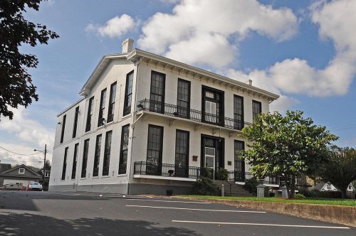
8 listings: 5 buildings, among them the Waldomore (listed 1978, the first), and 3 historic districts, the Clarksburg Downtown Historic District, the Quality Hill Historic District and the Glen Elk Historic District, with 283 contributing buildings. 293 historic buildings in all.
How old are the homes in Clarksburg?
40% of Clarksburg’s homes were built before 1940 (Census estimate, ±5.0 points), against a typical 13% for a West Virginia town; the median home was built in 1948.
Founding dates: Wikidata, Wikipedia, the U.S. post office records of Blevins & Helbock (CC0) and the Census. Homes by year built: Census ACS 2020–24. National Register of Historic Places: National Park Service (list of May 22, 2026). Old photos, postcards and papers: Wikimedia Commons, the Library of Congress and other public archives, credited on each item’s page. Maps: U.S. Geological Survey historical topographic maps (via Esri) and Sanborn fire-insurance maps (Library of Congress). History text and census tables: Wikipedia (CC BY-SA 4.0). Places that used to be: USGS Geographic Names Information System (2021).
From Wikimedia Commons (12), the National Register of Historic Places (8), Wikipedia, Wikidata and Wikipedia for famous people, U.S. Geological Survey historical maps, U.S. Census counts (via Wikipedia), the US Post Offices dataset (Blevins & Helbock), the USGS Geographic Names Information System, Sanborn fire insurance maps (Library of Congress) and old county and town histories (Internet Archive). Archive images are copied here with their credits and licenses, shown on each photo’s page. Refreshed monthly.




 1861
 1861
 1861
 1863
 1863
 1863
 1898
 1902