The story
Read it all →How Wyocena came to be
From Wikipedia’s history of Wyocena.
A tornado struck the village on April 25, 2008, destroying several homes.
Text from Wikipedia, licensed CC BY-SA 4.0.
Each edition grades its towns against each other only.
More historic than 31% of U.S. towns. What drives it
Below: maps from 1957 on and the census since 1850.
More historic than 31% of U.S. towns, on its age, its old homes and the National Register.
On its age, its old homes and the National Register, Wyocena is more historic than 31% of U.S. towns. Its share of homes from before 1940 holds the grade up; its National Register listings pull it down.
Wisconsin towns list more on the Register than most of the country (a typical Wisconsin town has 3.0 per 10,000 residents, the U.S. 2.4), so Wyocena’s 0.0 sits below most of its state (28% of Wisconsin towns have fewer) while its 0 listings outnumber those of 23% of U.S. towns.
Founding year: our sources. Homes: Census ACS 2020–24. National Register: National Park Service, May 2026 list; each listing counted once (boundary changes and added documentation belong to their listing), and a historic district counts its contributing buildings. How TownRatings grades history →
Read from the archive, the National Register and the record. The page puts what stands out first.
The first neighbors to add old photos shape how Wyocena’s history is told.
From Wikipedia’s history of Wyocena.
A tornado struck the village on April 25, 2008, destroying several homes.
Text from Wikipedia, licensed CC BY-SA 4.0.
Passages that mention Wyocena, cut from the printed page as they were published.

Town of Otsego— Village of Otsego— Village of Rio— Village of Doylestown — Town OF Pacific — Town of Randolph — Town of Scott — Town of Springvale — Town of West Point— Town of Wyocena — Village of Wyocena — Village of Pabdeeville. town of OTSEGO. At a meeting of the County Commissioners, held in January, 1849, all of Township 11, Range 11, was organized into a town, to which was given the name of Otsego, and the house of Edward Williams designated as the place for holding the first election. The name Otsego was chosen by the early settlers in honor of Otsego, N. Y., from which place a number had emi-
Text read by machine from the scan; it may contain errors.
Mr. Coapman came to Wisconsin with his family in March, 1855, being on the first passenger train that crossed the suspension bridge at Niagara Falls. They located at that time in the town of Wyocena ; lived on the Ellis farm one year, then removed to the village of Wyocena, and resided there till his death, April 6, 1878. He left a widow and four children. The oldest daughter, Alice T., is the wife of Elmer Food, Principal of the high school at Lodi, Wis. ; Ida M. is the wife of F. W. Farrington (dentist), of Wyocena ; the two sons, W. J. and Lynn N., reside in Wyocena. Mr. Coapman enlisted Oct. 9, 1861, in the 8th W. V. I., but the band, to which he belonged, was mustered out of service by special order, in 1862. After he returned from the army, he went into the grocery business, but sold out when
Text read by machine from the scan; it may contain errors.Scans and text from the Internet Archive. Books published in 1930 or earlier, which are in the public domain.
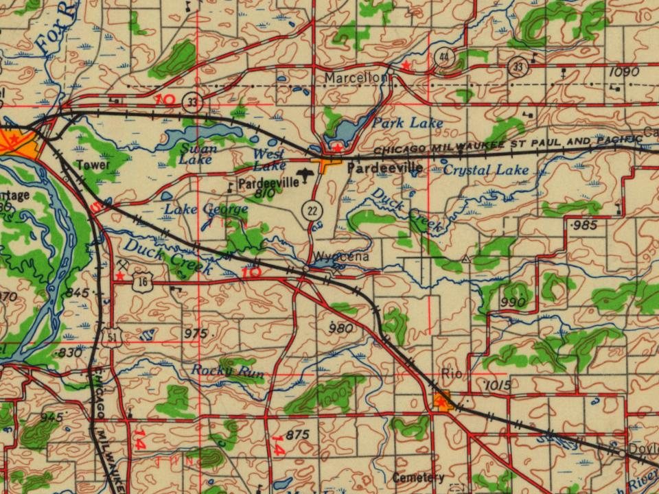
Every edition of the U.S. Geological Survey’s map of Wyocena. Tap a year, or press play to watch the town change.

U.S. Geological Survey historical topographic maps (public domain), via Esri’s collection of the scans. The red ring marks the center of Wyocena.
Between 101 and 809 people in every census since 1850.
15 censuses, 1850–2020.
U.S. Census Bureau decennial counts, from the census table on Wyocena’s Wikipedia page.
Nobody well known was born in Wyocena itself, so here are the best known from just nearby.



Places and cemeteries from the USGS Geographic Names Information System (2021).
Each neighbor’s History grade, on the same three inputs.
Wyocena is more historic than 31% of U.S. towns. The History grade combines the town’s founding era, the share of homes built before 1940 and its National Register listings. It’s a character grade, so it isn’t part of the overall grade. How it works.
11% of Wyocena’s homes were built before 1940 (Census estimate, ±5.0 points), against a typical 12% for a Wisconsin town; the median home was built in 1990.
What the archives can’t tell you, neighbors can.
Founding dates: Wikidata, Wikipedia, the U.S. post office records of Blevins & Helbock (CC0) and the Census. Homes by year built: Census ACS 2020–24. National Register of Historic Places: National Park Service (list of May 22, 2026). Old photos, postcards and papers: Wikimedia Commons, the Library of Congress and other public archives, credited on each item’s page. Maps: U.S. Geological Survey historical topographic maps (via Esri) and Sanborn fire-insurance maps (Library of Congress). History text and census tables: Wikipedia (CC BY-SA 4.0). Places that used to be: USGS Geographic Names Information System (2021).
From Wikimedia Commons (6), Wikipedia, U.S. Geological Survey historical maps, U.S. Census counts (via Wikipedia), the USGS Geographic Names Information System and old county and town histories (Internet Archive). Archive images are copied here with their credits and licenses, shown on each photo’s page. Refreshed monthly.
 2019
 2014
 2014
 2014
 2014
 2004