Founding year: Wikipedia. First post office: 1895.The full story ↓
History grade
What drives Watertown’s History grade
On its age, its old homes and the National Register, Watertown is more historic than 69% of U.S. towns. Its share of homes from before 1940 holds the grade up; its National Register listings pull it down.
B+
HistoryA character grade: shown, never part of Watertown’s overall grade.
Wisconsin towns list more on the Register than most of the country (a typical Wisconsin town has 3.0 per 10,000 residents, the U.S. 2.4), so Watertown’s 0.0 sits below most of its state (28% of Wisconsin towns have fewer) while its 0 listings outnumber those of 23% of U.S. towns.
NoteThe founding year comes from Wikipedia alone; no second source gives 1836.
How sure. Graded on any two of the three inputs instead, the letter would range from B− to A. The pre-1940 share is a Census survey estimate (±6.0 points).
Founding year: Wikipedia (other dates in Quick answers). Homes: Census ACS 2020–24. National Register: National Park Service, May 2026 list; each listing counted once (boundary changes and added documentation belong to their listing), and a historic district counts its contributing buildings. How TownRatings grades history →
What stands out about Watertown’s past
Read from the archive, the National Register and the record. The page puts what stands out first.
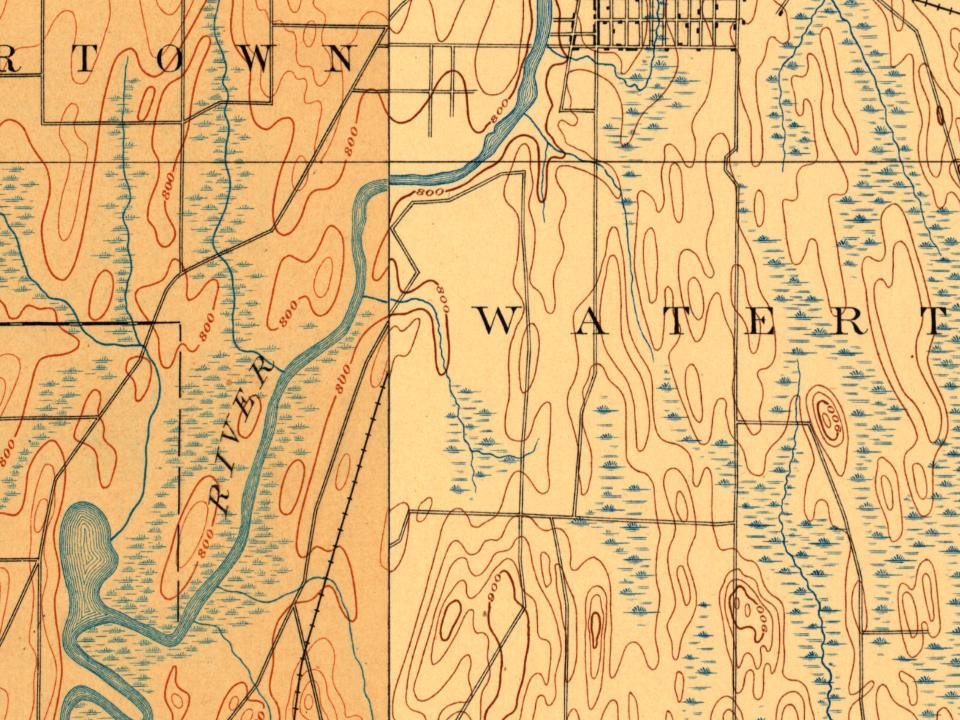
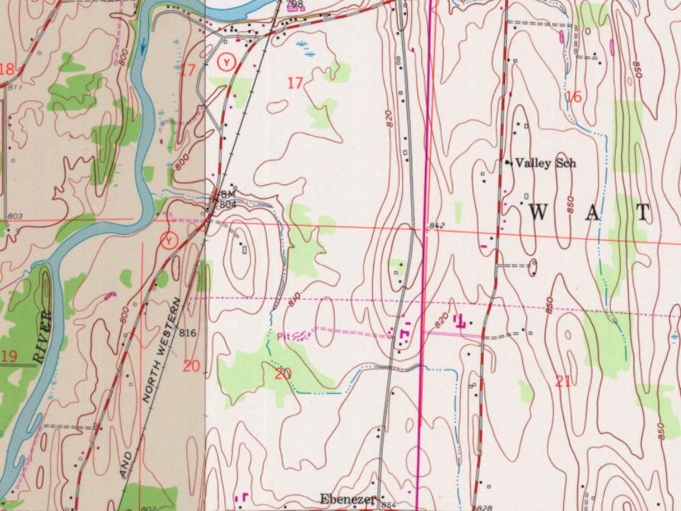
Every edition of the U.S. Geological Survey’s map of Watertown. Tap a year, or press play to watch the town change.
1892Watertown sheet · 1:62,500
U.S. Geological Survey historical topographic maps (public domain), via Esri’s collection of the scans. The red ring marks the center of Watertown.
Every building
Watertown, building by building, 1884–1915
Fire insurance maps drew every building, what it was made of and what it was used for, so insurers could price the risk of fire. Pick a year, then a sheet.
Watertown was first settled by Timothy Johnson, who built a cabin on the west side of the Rock River in 1836. He was born in Middleton, Middlesex County, Connecticut, on June 28, 1792. A park on the west side of the city is named in his honor. The area was settled to utilize the power of the Rock River, which falls 20 feet (6.1 m) in two miles (two 10-foot (3.0 m) dams). In contrast, the Rock River falls only 34 feet (10 m) in 58 miles (93 km) upstream from Watertown. The water power was first used for sawmills, and later prompted the construction of two hydroelectric dams, one downtown (where the river flows south) and one on the eastern edge of the city (where the river flows north).
Passages that mention Watertown, cut from the printed page as they were published.
The history of Jefferson county, Wisconsin, containing ... biographical sketches ..1879 · page 334Read the page →
Read the text
Rock River has its source in Fond du Lac County, and, entering Jefferson County at the extreme northeast corner of the town of Ixonia, courses tortuously through that town to the north line of the town of Concord, where it is joined by the Oconomowoc River. It then runs in a northwesterly direction through the town and city of Watertown, passing again into Dodge County, but turns abruptly and flows south back through the town of Watertown, becoming the boundary line between the towns of Milford and Farmington, passing through the towns of Aztalan, Jefferson and Koshkonong, and leaving the county through Lake Koshkonong, one of the most beautiful sheets of water in the Northwest.
Text read by machine from the scan; it may contain errors.
The history of Jefferson county, Wisconsin, containing ... biographical sketches ..1879 · page 620Read the page →
Read the text
XELSON W. PIERCE, Agent of the M. & St. P. R. R. Co. at Watertown Junction, and proprietor of the Railway Eating House and Hotel ; born at Kingston, N. J., April 10, 1848 ; he was in the employ of the Camden & Amboy Railway Co. for three years prior to coming to Watertown in 1866 one year, he was at Watertown Station ; for the last twelve years, he has been agent at the Junction, and for four years, he has carried on the hotel and eating-house. Sept. 9, 1869, he married Miss >Liry Mitchell daughter of Thomas Mitchell, a native of England, who came to America about the year 1836, worked ic New York State a short time, and afterward for a short period in Ohio ; then came to Watertown, anc was for many years engaged in farming on Sec. 11, Watertown Township, where he died. Mrs. Pierce
Text read by machine from the scan; it may contain errors.
Scans and text from the Internet Archive. Books published in 1930 or earlier, which are in the public domain.
By decade
Watertown, decade by decade
4 decades in the archive, from the 1860s to the 1900s. Scroll each row; tap a photo for its story.
Nothing in the archives for these yearsWeddings on Main Street, storms, parades, school pictures, the old store. If it’s in your family album, it belongs here.
In 1836, according to Wikipedia’s history of the town. Watertown’s post office opened in 1895, and the census of 1850 counted 1,451 people here.
How does Watertown rank for history?
Watertown is more historic than 69% of U.S. towns. The History grade combines the town’s founding era, the share of homes built before 1940 and its National Register listings. It’s a character grade, so it isn’t part of the overall grade. How it works.
How old are the homes in Watertown?
27% of Watertown’s homes were built before 1940 (Census estimate, ±6.0 points), against a typical 12% for a Wisconsin town; the median home was built in 1975.
Founding dates: Wikidata, Wikipedia, the U.S. post office records of Blevins & Helbock (CC0) and the Census. Homes by year built: Census ACS 2020–24. National Register of Historic Places: National Park Service (list of May 22, 2026). Old photos, postcards and papers: Wikimedia Commons, the Library of Congress and other public archives, credited on each item’s page. Maps: U.S. Geological Survey historical topographic maps (via Esri) and Sanborn fire-insurance maps (Library of Congress). History text and census tables: Wikipedia (CC BY-SA 4.0). Places that used to be: USGS Geographic Names Information System (2021).
From Wikimedia Commons (3), the Library of Congress (3), Wikidata (6), Wikipedia, Wikidata and Wikipedia for famous people, U.S. Geological Survey historical maps, U.S. Census counts (via Wikipedia), the US Post Offices dataset (Blevins & Helbock), the USGS Geographic Names Information System, Sanborn fire insurance maps (Library of Congress) and old county and town histories (Internet Archive). Archive images are copied here with their credits and licenses, shown on each photo’s page. Refreshed monthly.







 1909
 1909

