Menasha’s post office opened in 1849, and 18% of its homes were built before 1940
More historic than 87% of U.S. towns · #52 of 362 in Wisconsin. What drives it
8 places in town are on the National Register, among them two historic districts with 27 buildings between them. Below: 3 old photos and papers, maps from 1884 on, and the census since 1860.
Founding year: the first Menasha post office (Blevins & Helbock, CC0).The full story ↓
History grade
What drives Menasha’s History grade
On its age, its old homes and the National Register, Menasha is more historic than 87% of U.S. towns, #52 of 362 in Wisconsin. All 3 inputs are above most U.S. towns; its National Register listings ranks highest and its share of homes from before 1940 lowest.
A
HistoryA character grade: shown, never part of Menasha’s overall grade.
Wisconsin towns list more on the Register than most of the country (a typical Wisconsin town has 3.0 per 10,000 residents, the U.S. 2.4), so Menasha’s 17.5 sits above most of its state (81% of Wisconsin towns have fewer) while its 32 historic buildings outnumber those of 82% of U.S. towns.
How sure. Graded on any two of the three inputs instead, the letter would range from A− to A. The pre-1940 share (±2.7 points) is firm at this size. The founding year is the first post office, not a stated founding date.
Founding year: the first post office (other dates in Quick answers). Homes: Census ACS 2020–24. National Register: National Park Service, May 2026 list; each listing counted once (boundary changes and added documentation belong to their listing), and a historic district counts its contributing buildings. How TownRatings grades history →
What stands out about Menasha’s past
Read from the archive, the National Register and the record. The page puts what stands out first.
Fire insurance maps drew every building, what it was made of and what it was used for, so insurers could price the risk of fire. Pick a year, then a sheet.
The Menominee people inhabited the Fox River Valley for over 10,000 years. Ancestors of the Ho-Chunk also occupied what is currently Menasha, with a village known as "Menashay" on what is now Doty Island, led by Chief Hootschope (Four Legs). In the 1600s, the Meskwaki established a village just north of Menasha. In 1730, a surprise attack by French soldiers and traders led by Captain Paul Marin resulted in the deaths of over 1,000 Meskwaki (Fox) people residing in the area. The bodies were subsequently piled into a mass grave 12 feet high, 60 feet long, and 35 feet wide, known as Butte des Morts ("Hill of the Dead"). Despite the protests of early Wisconsin preservationist Increase A. Lapham—who argued there was "neither necessity nor excuse for its destruction"—the hill was leveled in 1863 to make way for a Chicago and North Western Railway line. The company used the excavated earth as …
Passages that mention Menasha, cut from the printed page as they were published.
History of Winnebago County, Wisconsin, and early history of the Northwest1880Read the page →
Read the text
Two days later, January 6, the Town of Menasha was set off from Neenah, and organized. (See Town of Menasha.) In November, 1856, representations having been made to the Board of Supervisors, that no suitable place could be found for holding court, Mr. Markham, one of the members, submitted a resolution for the appoint-
Text read by machine from the scan; it may contain errors.
History of Winnebago County, Wisconsin, and early history of the Northwest1880 · page 230Read the page →
Read the text
The Village of Menasha had for some time agitated the subject and claimed that the election should be held alternately at that place, and, until April 5, 1853, the question was to be contested at the polls, but Neenah out-voted the Town of Menasha. The question being upon the place of holding the next election, and of dividing the town, one hundred and
Text read by machine from the scan; it may contain errors.
Scans and text from the Internet Archive. Books published in 1930 or earlier, which are in the public domain.
Timeline
Menasha, 1849 to 1977
Woven from the archive, old maps, post office records, the National Register and the people born here.
Nothing in the archives for these yearsWeddings on Main Street, storms, parades, school pictures, the old store. If it’s in your family album, it belongs here.
The Menasha post office opened in 1849, the earliest record of the town by name (U.S. post office records).
How does Menasha rank for history?
Menasha is more historic than 87% of U.S. towns, #52 of 362 in Wisconsin. The History grade combines the town’s founding era, the share of homes built before 1940 and its National Register listings. It’s a character grade, so it isn’t part of the overall grade. How it works.
What is on the National Register in Menasha?
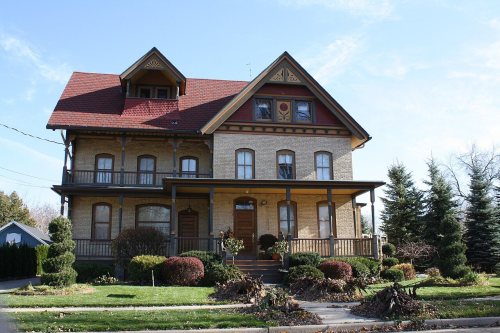
8 listings: 4 buildings, 2 historic districts, the Upper Main Street Historic District and the Washington Street Historic District, with 27 contributing buildings, and 2 structures. 32 historic buildings in all.
How old are the homes in Menasha?
18% of Menasha’s homes were built before 1940 (Census estimate, ±2.7 points), against a typical 12% for a Wisconsin town; the median home was built in 1974.
Founding dates: Wikidata, Wikipedia, the U.S. post office records of Blevins & Helbock (CC0) and the Census. Homes by year built: Census ACS 2020–24. National Register of Historic Places: National Park Service (list of May 22, 2026). Old photos, postcards and papers: Wikimedia Commons, the Library of Congress and other public archives, credited on each item’s page. Maps: U.S. Geological Survey historical topographic maps (via Esri) and Sanborn fire-insurance maps (Library of Congress). History text and census tables: Wikipedia (CC BY-SA 4.0). Places that used to be: USGS Geographic Names Information System (2021).
From Wikimedia Commons (3), Wikidata (3), the National Register of Historic Places (8), Wikipedia, Wikidata and Wikipedia for famous people, U.S. Geological Survey historical maps, U.S. Census counts (via Wikipedia), the US Post Offices dataset (Blevins & Helbock), the USGS Geographic Names Information System, Sanborn fire insurance maps (Library of Congress) and old county and town histories (Internet Archive). Archive images are copied here with their credits and licenses, shown on each photo’s page. Refreshed monthly.




 1880


