Appleton dates to 1847, and 19% of its homes were built before 1940
More historic than 90% of U.S. towns · #37 of 362 in Wisconsin. What drives it
21 places in town are on the National Register, among them six historic districts with 180 buildings between them. Below: 12 old photos and papers, maps from 1883 on, and the census since 1860.
Founding year: Wikipedia. First post office: 1849.The full story ↓
History grade
What drives Appleton’s History grade
On its age, its old homes and the National Register, Appleton is more historic than 90% of U.S. towns, #37 of 362 in Wisconsin. All 3 inputs are above most U.S. towns; its National Register listings ranks highest and its share of homes from before 1940 lowest.
A
HistoryA character grade: shown, never part of Appleton’s overall grade.
Wisconsin towns list more on the Register than most of the country (a typical Wisconsin town has 3.0 per 10,000 residents, the U.S. 2.4), so Appleton’s 26.3 sits above most of its state (84% of Wisconsin towns have fewer) while its 197 historic buildings outnumber those of 93% of U.S. towns.
How sure. Graded on any two of the three inputs instead, the letter would range from A− to A. The pre-1940 share (±1.3 points) is firm at this size. Two sources give 1847.
Founding year: Wikipedia (other dates in Quick answers). Homes: Census ACS 2020–24. National Register: National Park Service, May 2026 list; each listing counted once (boundary changes and added documentation belong to their listing), and a historic district counts its contributing buildings. How TownRatings grades history →
What stands out about Appleton’s past
Read from the archive, the National Register and the record. The page puts what stands out first.
The territory where Appleton is today was formerly occupied by the Ho-Chunk and the Menominee. The Menominee Nation ceded the territory to the United States in the Treaty of the Cedars in 1836. In the Menominee language, Appleton is known as Ahkōnemeh, or "watches for them place", while in Oneida it is known as twaˀsʌ́thaˀ.
The first European settlers in Appleton were fur traders seeking to do business with Fox River Valley Native Americans. Hippolyte Grignon built the White Heron in 1835 to house his family and serve as an inn and trading post.
Passages that mention Appleton, cut from the printed page as they were published.
Illustrated annual review of the Appleton Post, devoted to the city of Appleton, Wisconsin, its water power and industries1879 · page 14Read the page →
Read the text
aggi'egate of 2704 miles. Again the distance from New Orleans to Appleton, by rail, is 1091 miles and from Apj)leton to Cliicago 200 miles, making a total of 1291 miles, or a difference in favor of Appleton of 1413 miles. Allowing that the rates of transportation from New Orleans to LoweU, and from the former
Text read by machine from the scan; it may contain errors.
Illustrated annual review of the Appleton Post, devoted to the city of Appleton, Wisconsin, its water power and industries1879 · page 45Read the page →
Read the text
now closed, the Wis. 0. E. E. Co. has had surveys made from Menasha to this city, with the view of extending their line to this point. Appleton has become a place of much importance and the extent of its business has become so much of an attraction to all railroads in this vicinity that self interest prompts them
Text read by machine from the scan; it may contain errors.
Scans and text from the Internet Archive. Books published in 1930 or earlier, which are in the public domain.
Timeline
Appleton, 1847 to 2005
Woven from the archive, old maps, post office records, the National Register and the people born here.
Nothing in the archives for these yearsWeddings on Main Street, storms, parades, school pictures, the old store. If it’s in your family album, it belongs here.
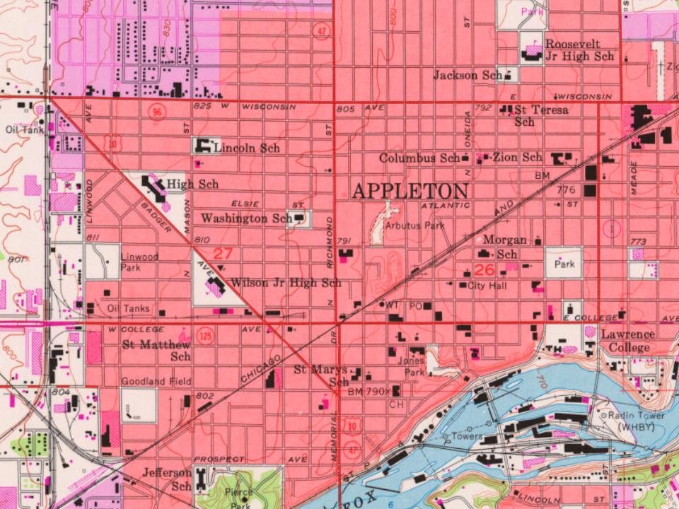
Every edition of the U.S. Geological Survey’s map of Appleton. Tap a year, or press play to watch the town change.
1955Appleton sheet · 1:24,000
U.S. Geological Survey historical topographic maps (public domain), via Esri’s collection of the scans. The red ring marks the center of Appleton.
Every building
Appleton, building by building, 1883–1911
Fire insurance maps drew every building, what it was made of and what it was used for, so insurers could price the risk of fire. Pick a year, then a sheet.
In 1847, according to Wikipedia’s history of the town. Appleton’s post office opened in 1849, and the census of 1860 counted 2,345 people here.
How does Appleton rank for history?
Appleton is more historic than 90% of U.S. towns, #37 of 362 in Wisconsin. The History grade combines the town’s founding era, the share of homes built before 1940 and its National Register listings. It’s a character grade, so it isn’t part of the overall grade. How it works.
What is on the National Register in Appleton?
21 listings: 15 buildings, among them the Main Hall, Lawrence University (listed 1974, the first), and 6 historic districts with 180 contributing buildings. 197 historic buildings in all.
How old are the homes in Appleton?
19% of Appleton’s homes were built before 1940 (Census estimate, ±1.3 points), against a typical 12% for a Wisconsin town; the median home was built in 1971.
Founding dates: Wikidata, Wikipedia, the U.S. post office records of Blevins & Helbock (CC0) and the Census. Homes by year built: Census ACS 2020–24. National Register of Historic Places: National Park Service (list of May 22, 2026). Old photos, postcards and papers: Wikimedia Commons, the Library of Congress and other public archives, credited on each item’s page. Maps: U.S. Geological Survey historical topographic maps (via Esri) and Sanborn fire-insurance maps (Library of Congress). History text and census tables: Wikipedia (CC BY-SA 4.0). Places that used to be: USGS Geographic Names Information System (2021).
From Wikimedia Commons (6), the Library of Congress (6), Wikidata (12), the National Register of Historic Places (21), Wikipedia, Wikidata and Wikipedia for famous people, U.S. Geological Survey historical maps, U.S. Census counts (via Wikipedia), the US Post Offices dataset (Blevins & Helbock), the USGS Geographic Names Information System, Sanborn fire insurance maps (Library of Congress) and old county and town histories (Internet Archive). Archive images are copied here with their credits and licenses, shown on each photo’s page. Refreshed monthly.


 1880
 1880
 1880
 c. 1882
 1898
 1898
 1898