Wikipedia doesn’t have a history of Hillsboro yet. The photos, dates and memories neighbors add here are how it gets written.
Hillsboro is a city in Vernon County, Wisconsin, United States. The population was 1,397 at the 2020 Census. The city is located within the Town of Hillsboro.
Between the 2010 and 2020 censuses its population fell from 807 to 787 (-2%).
Intro from Wikipedia. Population: U.S. Census Bureau.
From the old history books
What they wrote about Hillsboro in 1884
Passages that mention Hillsboro, cut from the printed page as they were published.
History of Vernon county, Wisconsin ..1884 · page 231Read the page →
Read the text
In 1855-6 I was assessor and collector of taxes tor the town of Viroqua, with the exception of the new town of Hillsboro, which embraced the two townships east of the meridian line. The town of Viroqua embraced all the territory of the northeastern part of the county, including the present town of Christiana. In the winter when I was collecting
Text read by machine from the scan; it may contain errors.
History of Vernon County, Wisconsin, together with sketches of its towns, villages and townships, educational, civil, military and political history1884 · page 231Read the page →
Read the text
In 1855-6 I was assessor and collector of taxes tor the town of Viroqua, with the exception of the new town of Hillsboro, which embraced the two townships east of the meridian line. The town of Viroqua embraced all the territory of the northeastern part of the county, including the present town of Christiana. In the winter when I was collecting
Text read by machine from the scan; it may contain errors.
History of Vernon County, Wisconsin, together with sketches of its towns, villages and townships, educational, civil, military and political history1884 · page 183Read the page →
Read the text
Sally L. Tripp, for adultery, came before the circuit court at the fall term, 1880. Emmons was the hired man of Mr. Tripp, the husband of the co-defendant, in the town of Hillsboro. She plead guilty, and was sentenced by the county judge to pay a fine of $200. It was paid by her husband. Emmons was tried by circuit court, found guilty, and sentenced to
Text read by machine from the scan; it may contain errors.
Scans and text from the Internet Archive. Books published in 1930 or earlier, which are in the public domain.
Timeline
Hillsboro, 1869 to 1931
Woven from the archive, old maps, post office records, the National Register and the people born here.
Nothing in the archives for these yearsWeddings on Main Street, storms, parades, school pictures, the old store. If it’s in your family album, it belongs here.
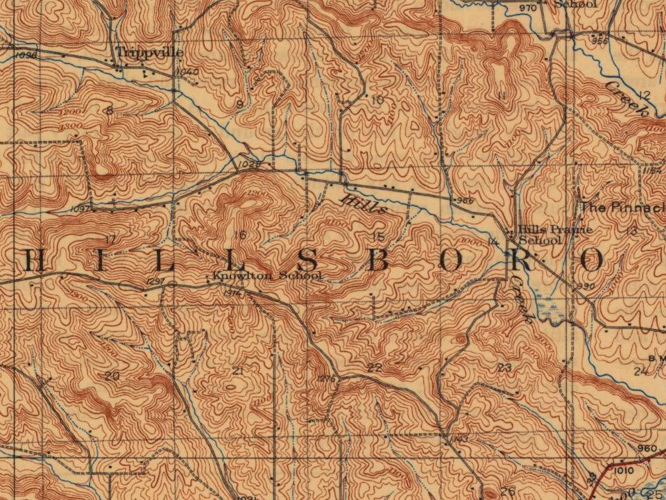
Every edition of the U.S. Geological Survey’s map of Hillsboro. Tap a year, or press play to watch the town change.
1927Hillsboro sheet · 1:62,500
U.S. Geological Survey historical topographic maps (public domain), via Esri’s collection of the scans. The red ring marks the center of Hillsboro.
Every building
Hillsboro, building by building, 1904–1914
Fire insurance maps drew every building, what it was made of and what it was used for, so insurers could price the risk of fire. Pick a year, then a sheet.
Founding dates: Wikidata, Wikipedia, the U.S. post office records of Blevins & Helbock (CC0) and the Census. Homes by year built: Census ACS 2020–24. National Register of Historic Places: National Park Service (list of May 22, 2026). Old photos, postcards and papers: Wikimedia Commons, the Library of Congress and other public archives, credited on each item’s page. Maps: U.S. Geological Survey historical topographic maps (via Esri) and Sanborn fire-insurance maps (Library of Congress). History text and census tables: Wikipedia (CC BY-SA 4.0). Places that used to be: USGS Geographic Names Information System (2021). How TownRatings grades history →
From Wikimedia Commons (12), Wikidata and Wikipedia for famous people, U.S. Geological Survey historical maps, U.S. Census counts (via Wikipedia), the US Post Offices dataset (Blevins & Helbock), the USGS Geographic Names Information System, Sanborn fire insurance maps (Library of Congress) and old county and town histories (Internet Archive). Archive images are copied here with their credits and licenses, shown on each photo’s page. Refreshed monthly.


 2024
 2023
 2023
 2023
 2023
 2023
 2023
 2016
 2007
 2007
 2007