Guest, Sign inJoin

Post to Greenfield

We’ll email a one-tap link to publish your post. No password, and nothing is public until you click it.
Already a member? Sign in
–Not graded
History · Greenfield

23% of Greenfield’s homes were built before 1940

Its Register listings are the Man Mound and the Simonds 10-Sided Barn. Below: maps from 1895 on and old-book passages.

2on the National Register
23%homes built before 1940

What stands out about Greenfield’s past

Read from the archive, the National Register and the record. The page puts what stands out first.

★ What stands out · Help out

Start Greenfield’s collection

The first neighbors to add old photos shape how Greenfield’s history is told.

Decades since 1900 with photos
00s10s20s30s40s50s60s70s80s90s
0 of 10 decades. The empty ones are waiting for someone’s album.
On the map

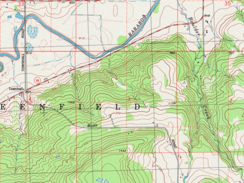
Greenfield on the map, 1895 to 1994

Every edition of the U.S. Geological Survey’s map of Greenfield. Tap a year, or press play to watch the town change.

Greenfield on the 1895 USGS mapGreenfield on the 1908 USGS mapGreenfield on the 1959 USGS mapGreenfield on the 1974 USGS mapGreenfield on the 1994 USGS map1895Baraboo sheet · 1:62,500

U.S. Geological Survey historical topographic maps (public domain), via Esri’s collection of the scans. The red ring marks the center of Greenfield.

The story so far

Greenfield, in brief

Wikipedia doesn’t have a history of Greenfield yet. The photos, dates and memories neighbors add here are how it gets written.

The Town of Greenfield is a located in Sauk County, Wisconsin, United States. The population was 909 at the 2020 census. The town was named after Greenfield, Massachusetts.

Between the 2010 and 2020 censuses its population fell from 932 to 909 (-2%).

Intro from Wikipedia. Population: U.S. Census Bureau.

From the old history books

What they wrote about Greenfield in 1880

Passages that mention Greenfield, cut from the printed page as they were published.

The town of Greenfield originally belonged to the town of Brooklyn, and was set off as a separate town about 1853. Lemuel Thompson is believed to have been the first Chairman of the Board of Supervisors in the town.
The history of Sauk County, Wisconsin, containing an account of its settlement, growth, development and resources ... biographical sketches ..1880 · page 626Read the page →
Read the text

The town of Greenfield originally belonged to the town of Brooklyn, and was set off as a separate town about 1853. Lemuel Thompson is believed to have been the first Chairman of the Board of Supervisors in the town.

Text read by machine from the scan; it may contain errors.

Scans and text from the Internet Archive. Books published in 1930 or earlier, which are in the public domain.

By decade

Greenfield, decade by decade

On the National Register

2 historic places in Greenfield

The country’s official list of buildings and places worth saving.

places listed
2
National Historic Landmarks
0
none yet
historic buildings protected
2
each building in a district counts
first listed
1978
Man Mound
All 2 listings

National Park Service, National Register of Historic Places. Photos from Wikimedia Commons, credited on each place’s page.

Famous people

Famous people close to Greenfield

Nobody well known was born in Greenfield itself, so here are the best known from just nearby.

See all →
Places that used to be

Places now gone and burying grounds

Gone or out of use
Glenville SchoolschoolIkey SchoolschoolMan Mound SchoolschoolSunny Hill SchoolschoolSunset View SchoolschoolSunshine Valley Schoolschool
5cemeteries and burying grounds inside Greenfield
BrewsterJonesKoerthTuckerZuch

Places and cemeteries from the USGS Geographic Names Information System (2021).

Stories next door

History across the town line

Each neighbor’s History grade, on the same three inputs.

Questions about Greenfield’s history

What is on the National Register in Greenfield?

Two places: the Man Mound (listed 1978) and the Simonds 10-Sided Barn (2020).

Memory lane

What the archives can’t tell you, neighbors can.

Town Square →
Start a conversation
Sources

Where this page comes from

Founding dates: Wikidata, Wikipedia, the U.S. post office records of Blevins & Helbock (CC0) and the Census. Homes by year built: Census ACS 2020–24. National Register of Historic Places: National Park Service (list of May 22, 2026). Old photos, postcards and papers: Wikimedia Commons, the Library of Congress and other public archives, credited on each item’s page. Maps: U.S. Geological Survey historical topographic maps (via Esri) and Sanborn fire-insurance maps (Library of Congress). History text and census tables: Wikipedia (CC BY-SA 4.0). Places that used to be: USGS Geographic Names Information System (2021). How TownRatings grades history →

From Wikimedia Commons (5), the National Register of Historic Places (2), U.S. Geological Survey historical maps, the USGS Geographic Names Information System and old county and town histories (Internet Archive). Archive images are copied here with their credits and licenses, shown on each photo’s page. Refreshed monthly.