Wikipedia doesn’t have a history of Greenwater yet. The photos, dates and memories neighbors add here are how it gets written.
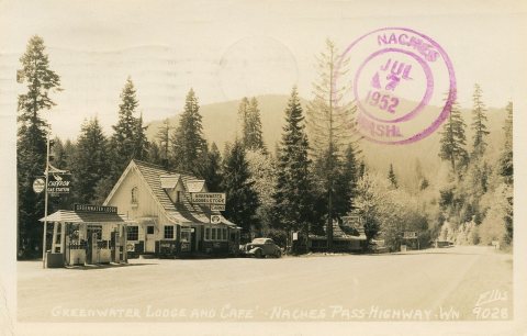
Greenwater is a census-designated place (CDP) in the northwest United States in Pierce County, Washington. Southeast of Seattle, the population was 67 at the 2010 census, down from 91 in 2000. At the 2020 census, the population was 95. Based on per capita income, Greenwater ranks 17th of 522 areas in the state of Washington to be ranked, and is the highest in Pierce County. East of Enumclaw on Highway 410, Greenwater gains much of its popularity as a town for hikers and skiers on their way south to Mount Rainier National Park and Crystal Mountain ski area. Three popular campgrounds reside in Greenwater: Silver Springs, The Dalles, and Buck Creek.
Between the 2010 and 2020 censuses its population grew from 67 to 95 (+42%).
Intro from Wikipedia. Population: U.S. Census Bureau.
Founding dates: Wikidata, Wikipedia, the U.S. post office records of Blevins & Helbock (CC0) and the Census. Homes by year built: Census ACS 2020–24. National Register of Historic Places: National Park Service (list of May 22, 2026). Old photos, postcards and papers: Wikimedia Commons, the Library of Congress and other public archives, credited on each item’s page. Maps: U.S. Geological Survey historical topographic maps (via Esri) and Sanborn fire-insurance maps (Library of Congress). History text and census tables: Wikipedia (CC BY-SA 4.0). Places that used to be: USGS Geographic Names Information System (2021). How TownRatings grades history →
From Wikimedia Commons (12), U.S. Geological Survey historical maps and U.S. Census counts (via Wikipedia). Archive images are copied here with their credits and licenses, shown on each photo’s page. Refreshed monthly.

 2013
 2013
 2013
 2013
 2013
 2013
 2013
 2013
 2013
 2013
 2013
 2012


