Montpelier dates to 1781, and 38% of its homes were built before 1940
More historic than 97% of U.S. towns · #14 of 71 in Vermont. What drives it
5 places in town are on the National Register, among them the Vermont Statehouse, a National Historic Landmark, and a historic district with 473 buildings. Below: 11 old photos and papers, maps from 1884 on, and the census since 1800.
On its age, its old homes and the National Register, Montpelier is more historic than 97% of U.S. towns, #14 of 71 in Vermont. All 3 inputs are above most U.S. towns; its National Register listings ranks highest and its age lowest.
A+
HistoryA character grade: shown, never part of Montpelier’s overall grade.
Vermont towns list more on the Register than most of the country (a typical Vermont town has 147 per 10,000 residents, the U.S. 2.4), so Montpelier’s 598 sits above most of its state (89% of Vermont towns have fewer) while its 479 historic buildings outnumber those of 97% of U.S. towns.
How sure. Graded on any two of the three inputs instead, the letter would range from A to A+. The pre-1940 share is a Census survey estimate (±3.6 points). Two sources give 1781.
Founding year: Wikipedia (other dates in Quick answers). Homes: Census ACS 2020–24. National Register: National Park Service, May 2026 list; each listing counted once (boundary changes and added documentation belong to their listing), and a historic district counts its contributing buildings. How TownRatings grades history →
What stands out about Montpelier’s past
Read from the archive, the National Register and the record. The page puts what stands out first.
The country’s official list of buildings and places worth saving. One is a National Historic Landmark, the highest tier. Boundary changes and added documentation are counted with their listing.
National Park Service, National Register of Historic Places. Photos from Wikimedia Commons, credited on each place’s page.
People over time
Montpelier, census by census
Lost half of its people between 1820 and 1830, then grew 6-fold.
23 censuses, 1800–2020.
U.S. Census Bureau decennial counts, from the census table on Montpelier’s Wikipedia page.
Every building
Montpelier, building by building, 1884–1915
Fire insurance maps drew every building, what it was made of and what it was used for, so insurers could price the risk of fire. Pick a year, then a sheet.
The meadows and flats of the Winooski River were well known among natives for their corn-raising capacities. The natural site of Montpelier made it a favorite residence for the natives who first inhabited the land. The level plain of nearly two hundred acres of the rich farmland, sheltered from winds by the surrounding valley made the area comparatively warm and comfortable. Its position near the confluence of many streams allowed for favorable hunting, fishing, and trading. Native mounds, tombstones, and other memorials of aboriginal life and death were found in Montpelier, or in the vicinity, by the first settlers, and traces of some of them still remain.
Passages that mention Montpelier, cut from the printed page as they were published.
The history of Washington county, in the Vermont historical gazetteer1882 · page 251Read the page →
Read the text
From the first Vermont grant of the town of Montpelier, Oct. 21, 1780, to Jan. I, 1849, the territory known by that name embraced the present towns of Montpelier and East Monpelier ; hence this paper will for that period give the history of the two existing towns under the original name, and of the present town of Mont-
Text read by machine from the scan; it may contain errors.
The History of Washington County in the Vermont historical gazetteer1882 · page 251Read the page →
Read the text
From the first Vermont grant of the town of Montpelier, Oct. 21, 1780, to Jan. I, 1849, the territory known by that name embraced the present towns of Montpelier and East Monpelier ; hence this paper will for that period give the history of the two existing towns under the original name, and of the present, town of Mont-
Text read by machine from the scan; it may contain errors.
The History of Washington County in the Vermont historical gazetteer1882 · page 301Read the page →
Read the text
The files of Montpelier newspapers, for the year 1830, alone contain railroad matter enough to fill at least two respectable volumes ; and that was 4 years before the first locomotive had been brought into New England, and J years before the first New England road had been completed.
Text read by machine from the scan; it may contain errors.
The history of Washington county, in the Vermont historical gazetteer1882 · page 301Read the page →
Read the text
The files of Montpelier newspapers, for the year 1830, alone contain railroad matter enough to fill at least two respectable volumes : and that was 4 years before the first locomotive had been brought into New England, and 5 years before the first New England road had been completed.
Text read by machine from the scan; it may contain errors.
Scans and text from the Internet Archive. Books published in 1930 or earlier, which are in the public domain.
Timeline
Montpelier, 1781 to 1993
Woven from the archive, old maps, post office records, the National Register and the people born here.
In 1781, according to Wikipedia’s history of the town. Montpelier’s post office opened in 1798, and the census of 1800 counted 890 people here.
How does Montpelier rank for history?
Montpelier is more historic than 97% of U.S. towns, #14 of 71 in Vermont. The History grade combines the town’s founding era, the share of homes built before 1940 and its National Register listings. It’s a character grade, so it isn’t part of the overall grade. How it works.
What is on the National Register in Montpelier?
5 listings: 4 buildings, among them the Vermont Statehouse (a National Historic Landmark since 1970), and 1 historic district, the Montpelier Historic District, with 473 contributing buildings. 479 historic buildings in all.
How old are the homes in Montpelier?
38% of Montpelier’s homes were built before 1940 (Census estimate, ±3.6 points), against a typical 22% for a Vermont town; the median home was built in 1955.
Founding dates: Wikidata, Wikipedia, the U.S. post office records of Blevins & Helbock (CC0) and the Census. Homes by year built: Census ACS 2020–24. National Register of Historic Places: National Park Service (list of May 22, 2026). Old photos, postcards and papers: Wikimedia Commons, the Library of Congress and other public archives, credited on each item’s page. Maps: U.S. Geological Survey historical topographic maps (via Esri) and Sanborn fire-insurance maps (Library of Congress). History text and census tables: Wikipedia (CC BY-SA 4.0). Places that used to be: USGS Geographic Names Information System (2021).
From Wikimedia Commons (11), Wikidata (1), the National Register of Historic Places (5), Wikipedia, Wikidata and Wikipedia for famous people, U.S. Geological Survey historical maps, U.S. Census counts (via Wikipedia), the US Post Offices dataset (Blevins & Helbock), the USGS Geographic Names Information System, Sanborn fire insurance maps (Library of Congress) and old county and town histories (Internet Archive). Archive images are copied here with their credits and licenses, shown on each photo’s page. Refreshed monthly.


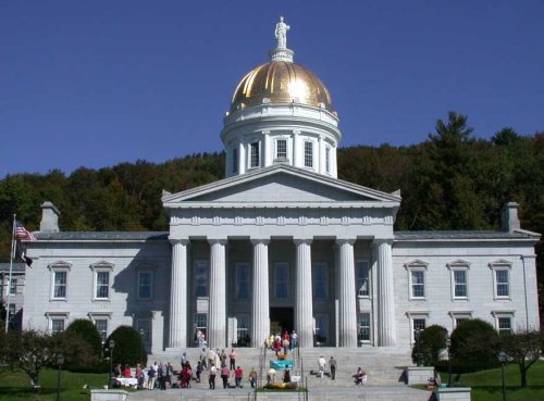 ★ Landmark
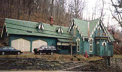

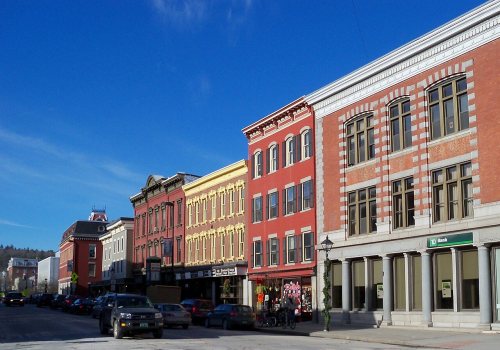





 c. 1870
 c. 1870
 c. 1870
 c. 1870
 c. 1870
 c. 1870
 c. 1870
 c. 1870


