Guest, Sign inJoin

Post to Hancock

We’ll email a one-tap link to publish your post. No password, and nothing is public until you click it.
Already a member? Sign in
–Not graded
History · Hancock

Hancock dates to 1781, and 39% of its homes were built before 1940

Below: maps from 1915 on and the census since 1790.

1781founded
0on the National Register
39%homes built before 1940
1famous people
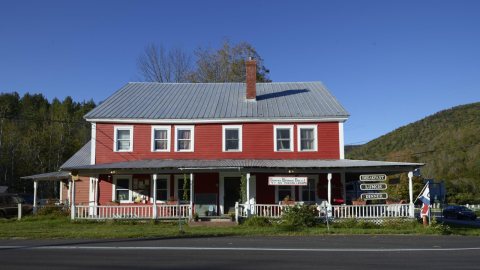
Photo: Jessamyn · Public domain
Quick answers

How Hancock began

When was Hancock founded?

1781

Hancock dates its founding to 1781 (Wikidata). It appears in the first U.S. census, 1790.

First census: 56 in 17902020 census: 359245 years
Founding year: Wikidata. First post office: 1811.

What stands out about Hancock’s past

Read from the archive, the National Register and the record. The page puts what stands out first.

★ What stands out · Help out

Start Hancock’s collection

The first neighbors to add old photos shape how Hancock’s history is told.

Decades since 1900 with photos
00s10s20s30s40s50s60s70s80s90s
0 of 10 decades. The empty ones are waiting for someone’s album.
On the map

Hancock on the map, 1915 to 1997

Every edition of the U.S. Geological Survey’s map of Hancock. Tap a year, or press play to watch the town change.

Hancock on the 1915 USGS mapHancock on the 1970 USGS mapHancock on the 1997 USGS map1915Rochester sheet · 1:62,500

U.S. Geological Survey historical topographic maps (public domain), via Esri’s collection of the scans. The red ring marks the center of Hancock.

Timeline

Hancock, 1781 to 1915

Woven from the archive, old maps, post office records, the National Register and the people born here.

  1. 18th century
  2. 1781
    FoundingHancock is established
  3. 19th century
  4. 1811Post officeThe Hancock post office opens
  5. 1866Born hereFred Thaddeus Austin is born here
  6. 20th century
  7. 1915On the mapFirst mapped by the U.S. Geological Survey
The story so far

Hancock, in brief

Wikipedia doesn’t have a history of Hancock yet. The photos, dates and memories neighbors add here are how it gets written.

Hancock is a town in Addison County, Vermont, United States. The town was named for John Hancock. The population was 359 at the 2020 census. Hancock is home to the Middlebury College Snow Bowl and contains Middlebury Gap through the Green Mountains. Hancock was one of thirteen Vermont towns isolated by flooding caused by Hurricane Irene in 2011.

Hancock was established in 1781. Between the 2010 and 2020 censuses its population grew from 323 to 359 (+11%).

Intro from Wikipedia. Population: U.S. Census Bureau.

From the old history books

What they wrote about Hancock in 1886

Passages that mention Hancock, cut from the printed page as they were published.

The other stream of importance in the town is Middlebury River, which rises in the mountains to the eastward in two branches, the principal one in the town of Hancock ; the branches unite in Ripton ; thence the stream descends the slope and joins Otter Creek near the south line of Middlebury. On th…
History of Addison county Vermont, with illustrations and biographical sketches of some of its prominent men and pioneers1886 · page 236Read the page →
Read the text

The other stream of importance in the town is Middlebury River, which rises in the mountains to the eastward in two branches, the principal one in the town of Hancock ; the branches unite in Ripton ; thence the stream descends the slope and joins Otter Creek near the south line of Middlebury. On this stream at East Middlebury are a series of falls, supplying several excellent water privileges ; the Muddy Branch, as it is called, is the main tributary of the river, and its current has turned several mills.

Text read by machine from the scan; it may contain errors.
to it nearly the relation of cause and effect. Private enterprise in Hancock at the opening of the present century had attained the proportions of to-day. The first saw-mill in town was built by Zenas Robbins about three-quarters of a mile west of the village, near the site of Simon Harlow's presen…
History of Addison county Vermont, with illustrations and biographical sketches of some of its prominent men and pioneers1886 · page 469Read the page →
Read the text

to it nearly the relation of cause and effect. Private enterprise in Hancock at the opening of the present century had attained the proportions of to-day. The first saw-mill in town was built by Zenas Robbins about three-quarters of a mile west of the village, near the site of Simon Harlow's present mill, but a little above it. He also had a grist-mill there. Stephenson & Hawley built and for some time operated a tannery near the Branch bridge in the village, on the south side of the bridge and on the east side of the road. It was finally burned. Moses Ingalls had a small one near the Church mill, and John Lord

Text read by machine from the scan; it may contain errors.

Scans and text from the Internet Archive. Books published in 1930 or earlier, which are in the public domain.

By decade

Hancock, decade by decade

People over time

Hancock, census by census

010020030040050018001850190019502000Peak: 472

Between 56 and 472 people in every census since 1790.

24 censuses, 1790–2020.

U.S. Census Bureau decennial counts, from the census table on Hancock’s Wikipedia page.

Places that used to be

Old corners, places now gone and burying grounds

Hancock’s post office has been open since 1811.

Hamlets and corners on the map
Branch School
Gone or out of use
Bingo CamplocaleBranch Schoolschool
5cemeteries and burying grounds inside Hancock
BranchLewisMazhamOld VillageVillage

US Post Offices dataset (Blevins & Helbock, CC0). Places and cemeteries from the USGS Geographic Names Information System (2021).

Stories next door

History across the town line

Each neighbor’s History grade, on the same three inputs.

Questions about Hancock’s history

What year was Hancock founded?

In 1781, according to Wikidata. Hancock’s post office opened in 1811, and the first U.S. census counted 56 people here in 1790.

Memory lane

What the archives can’t tell you, neighbors can.

Town Square →
Start a conversation
Sources

Where this page comes from

Founding dates: Wikidata, Wikipedia, the U.S. post office records of Blevins & Helbock (CC0) and the Census. Homes by year built: Census ACS 2020–24. National Register of Historic Places: National Park Service (list of May 22, 2026). Old photos, postcards and papers: Wikimedia Commons, the Library of Congress and other public archives, credited on each item’s page. Maps: U.S. Geological Survey historical topographic maps (via Esri) and Sanborn fire-insurance maps (Library of Congress). History text and census tables: Wikipedia (CC BY-SA 4.0). Places that used to be: USGS Geographic Names Information System (2021). How TownRatings grades history →

From Wikimedia Commons (6), the Library of Congress (6), Wikidata and Wikipedia for famous people, U.S. Geological Survey historical maps, U.S. Census counts (via Wikipedia), the US Post Offices dataset (Blevins & Helbock), the USGS Geographic Names Information System and old county and town histories (Internet Archive). Archive images are copied here with their credits and licenses, shown on each photo’s page. Refreshed monthly.