Guest, Sign inJoin

Post to Charleston

We’ll email a one-tap link to publish your post. No password, and nothing is public until you click it.
Already a member? Sign in
–Not graded
History · Charleston

Charleston dates to 1780, and 18% of its homes were built before 1940

Its Register listings are the Fox Hall and the J. S. Sweeney Store, Barn, Livery and Hall. Below: 2 old photos and papers, maps from 1919 on, and the census since 1810.

1780founded
2on the National Register
18%homes built before 1940
2old photos & papers
From Charleston’s archive · credits on each photo
Quick answers

How Charleston began

When was Charleston founded?

1780

Charleston dates its founding to 1780 (Wikidata). The census first counted it in 1810.

First census: 56 in 18102020 census: 1,021246 years
Founding year: Wikidata. First post office: 1833.The full story ↓

What stands out about Charleston’s past

Read from the archive, the National Register and the record. The page puts what stands out first.

★ What stands out · Help out

Start Charleston’s collection

The first neighbors to add old photos shape how Charleston’s history is told.

Decades since 1900 with photos
00s10s20s30s40s50s60s70s80s90s
1 of 10 decades. The empty ones are waiting for someone’s album.
On the map

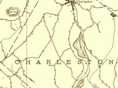
Charleston on the map, 1919 to 1953

Every edition of the U.S. Geological Survey’s map of Charleston. Tap a year, or press play to watch the town change.

Charleston on the 1919 USGS mapCharleston on the 1920 USGS mapCharleston on the 1953 USGS map1919Lake Memphremagog sheet · 1:62,500

U.S. Geological Survey historical topographic maps (public domain), via Esri’s collection of the scans. The red ring marks the center of Charleston.

Timeline

Charleston, 1780 to 1919

Woven from the archive, old maps, post office records, the National Register and the people born here.

  1. 18th century
  2. 1780
    FoundingCharleston is established
  3. 19th century
  4. 1833Post officeThe East Charleston post office opens
  5. 1833Post officeThe West Charleston post office opens
  6. 1860BuiltJ. S. Sweeney Store, Barn, Livery and Hall is built
  7. 20th century
  8. 1909In the archiveMaple sugar making
  9. 1919On the mapFirst mapped by the U.S. Geological Survey
The story

How Charleston came to be

From Wikipedia’s history of Charleston.

Read it all →

Native Abenakis told of how a large pond "ran away" similar to Runaway Pond in the 1780s before the area was explored by the descendants of Europeans.

Commodore Abraham Whipple was given a grant to the town, along with 50–60 of his shipmates. He called it "Navy". Abner Allen, from Barton, Vermont, was the first settler in 1803.

In 1825, the town of Navy changed its name to Charleston, presumably after a naval battle that had occurred off Charleston, South Carolina.

During the Civil War, Charleston furnished 121 enlisted men, 35 of whom were killed in action or died from the effects of wounds or disease contracted while in the service.

Text from Wikipedia, licensed CC BY-SA 4.0.

From the old history books

What they wrote about Charleston in 1882

Passages that mention Charleston, cut from the printed page as they were published.

Charleston contains two villages, 6 miles apart. Its market facilities are good, the East Village being situated 7 miles from the depot at Island Pond on the Grand Trunk railroad, and the West Village — the larger of the two — situated about 10 miles from Newport on the Connecticut and Passumpsic r…
The history of Orleans county, Vermont. Civil, ecclesiastical, biographical and military1882 · page 122Read the page →
Read the text

Charleston contains two villages, 6 miles apart. Its market facilities are good, the East Village being situated 7 miles from the depot at Island Pond on the Grand Trunk railroad, and the West Village — the larger of the two — situated about 10 miles from Newport on the Connecticut and Passumpsic railroad. The east part of the town contains a

Text read by machine from the scan; it may contain errors.
Lemuel Sturtevant and Stephen Cole built the first grist-mill at "West Charleston, in the year 1810. Stephen Cole also built the first framed house at West Charleston in 1811. The first saw-mill at East Charleston was erected by Jonas Allen in 1824, just above the present site of the dwelling-house…
The history of Orleans county, Vermont. Civil, ecclesiastical, biographical and military1882 · page 111Read the page →
Read the text

Lemuel Sturtevant and Stephen Cole built the first grist-mill at "West Charleston, in the year 1810. Stephen Cole also built the first framed house at West Charleston in 1811. The first saw-mill at East Charleston was erected by Jonas Allen in 1824, just above the present site of the dwelling-house of L. N. Melvin.— Stephen Cole put a small run of stone in the

Text read by machine from the scan; it may contain errors.

Scans and text from the Internet Archive. Books published in 1930 or earlier, which are in the public domain.

By decade

Charleston, decade by decade

One decade in the archive so far: the 1900s. Scroll each row; tap a photo for its story.

1910s–1990snothing yet
Nothing in the archives for these yearsWeddings on Main Street, storms, parades, school pictures, the old store. If it’s in your family album, it belongs here.
Add from your album
Then & now

Stand where they stood

No then-and-now pairs yet. Take a photo from the same spot as an old one and they appear here side by side.

Maple sugar making
Retake this viewMaple sugar making, 1909

Find the spot, match the angle, and add your photo. It becomes the first then-and-now pair on Charleston’s page.

Retake this view · +15
On the National Register

2 historic places in Charleston

The country’s official list of buildings and places worth saving.

places listed
2
National Historic Landmarks
0
none yet
historic buildings protected
5
each building in a district counts
first listed
1984
Fox Hall
Buildings

Architectural styles listings

Colonial Revival1
Shingle Style1
Greek Revival1

National Park Service, National Register of Historic Places. Photos from Wikimedia Commons, credited on each place’s page.

People over time

Charleston, census by census

02004006008001,0001,2001,4001850190019502000Peak: 1,278

Between 56 and 1,278 people in every census since 1810.

22 censuses, 1810–2020.

U.S. Census Bureau decennial counts, from the census table on Charleston’s Wikipedia page.

Famous people

Famous people close to Charleston

Nobody well known was born in Charleston itself, so here are the best known from just nearby.

See all →
Places that used to be

Old corners, places now gone and burying grounds

Old hamlets and crossroads still carry their names on the map.

East Charleston
1833–today
West Charleston
1833–today
18301930today
Hamlets and corners on the map
East CharlestonWest Charleston
Gone or out of use
Old Buck Schoolschool
6cemeteries and burying grounds inside Charleston
BlyhillBuckCrawford HillHillsideMorrillWest Charleston

US Post Offices dataset (Blevins & Helbock, CC0). Places and cemeteries from the USGS Geographic Names Information System (2021).

Stories next door

History across the town line

Each neighbor’s History grade, on the same three inputs.

Questions about Charleston’s history

What year was Charleston founded?

In 1780, according to Wikidata. Charleston’s post office opened in 1833, and the census of 1810 counted 56 people here.

What is on the National Register in Charleston?

Two places: the Fox Hall (listed 1984) and the J. S. Sweeney Store, Barn, Livery and Hall (1992).

Memory lane

What the archives can’t tell you, neighbors can.

Town Square →
Start a conversation
Sources

Where this page comes from

Founding dates: Wikidata, Wikipedia, the U.S. post office records of Blevins & Helbock (CC0) and the Census. Homes by year built: Census ACS 2020–24. National Register of Historic Places: National Park Service (list of May 22, 2026). Old photos, postcards and papers: Wikimedia Commons, the Library of Congress and other public archives, credited on each item’s page. Maps: U.S. Geological Survey historical topographic maps (via Esri) and Sanborn fire-insurance maps (Library of Congress). History text and census tables: Wikipedia (CC BY-SA 4.0). Places that used to be: USGS Geographic Names Information System (2021). How TownRatings grades history →

From Wikimedia Commons (4), the Library of Congress (2), Wikidata (1), the National Register of Historic Places (2), Wikipedia, U.S. Geological Survey historical maps, U.S. Census counts (via Wikipedia), the US Post Offices dataset (Blevins & Helbock), the USGS Geographic Names Information System and old county and town histories (Internet Archive). Archive images are copied here with their credits and licenses, shown on each photo’s page. Refreshed monthly.