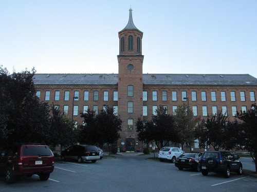
Bennington dates to 1749, and 36% of its homes were built before 1940
Among the most historic 1% of U.S. towns · #6 of 71 in Vermont. What drives it
29 places in town are on the National Register, among them nine historic districts with 396 buildings between them. Below: 21 old photos and papers, maps from 1885 on, and the census since 1790.
Founding year: Wikidata. First post office: 1783.The full story ↓
History grade
What drives Bennington’s History grade
On its age, its old homes and the National Register, Bennington is among the most historic 1% of U.S. towns, #6 of 71 in Vermont. All 3 inputs put Bennington near the top nationally; its age ranks highest.
A+
HistoryA character grade: shown, never part of Bennington’s overall grade.
Vermont towns list more on the Register than most of the country (a typical Vermont town has 147 per 10,000 residents, the U.S. 2.4), so Bennington’s 289 sits above most of its state (77% of Vermont towns have fewer) while its 441 historic buildings outnumber those of 97% of U.S. towns.
How sure. Graded on any two of the three inputs instead, the letter would still be A+. The pre-1940 share is a Census survey estimate (±5.6 points). Two sources give 1749.
Founding year: Wikidata (other dates in Quick answers). Homes: Census ACS 2020–24. National Register: National Park Service, May 2026 list; each listing counted once (boundary changes and added documentation belong to their listing), and a historic district counts its contributing buildings. How TownRatings grades history →
What stands out about Bennington’s past
Read from the archive, the National Register and the record. The page puts what stands out first.
Nothing in the archives for these yearsWeddings on Main Street, storms, parades, school pictures, the old store. If it’s in your family album, it belongs here.
First of the New Hampshire Grants, Bennington was chartered on January 3, 1749, by Colonial Governor Benning Wentworth and named in his honor. It was granted to William Williams and 61 others, mostly from Portsmouth, New Hampshire, making the town the oldest to be chartered in Vermont and outside of what is now New Hampshire, though Brattleboro had been settled earlier as a fort. The town was first settled in 1761 by four families from Hardwick and two from Amherst, Massachusetts. They were led by Capt. Samuel Robinson, who camped in the river valley on his return from the French and Indian War.
Passages that mention Bennington, cut from the printed page as they were published.
Centennial anniversary of the independence of the state of Vermont and the battle of Bennington1879Read the page →
Read the text
Battle of Bennington. 173 log huts which were standing near the bridge on both sides of the river. This point is where the river is now crossed by the covered railroad bridge, about three miles from North Bennington on the route to Troy. Baura, on his way from the Hudson and at his encampment, had been joined by a considerable number of Tories, many of them under the lead of Col. Francis Pfister, a half-pay British officer of
Text read by machine from the scan; it may contain errors.
Centennial anniversary of the independence of the state of Vermont and the battle of Bennington1879Read the page →
Read the text
340 Bennington Centennial. aggression made at Concord and Lexington was another; the formation of the national constitution under the lead of Washington was another. Secondary in importance to such events as these, yet no less characteristic of the spirit and capacity of the New England people, were such incidents as the revolt against Andros in 1689, the battle of Bunker Hill in 1775, and the victory at Bennington two years later. These two battles, indeed,
Text read by machine from the scan; it may contain errors.
Scans and text from the Internet Archive. Books published in 1930 or earlier, which are in the public domain.
Timeline
Bennington, 1749 to 1926
Woven from the archive, old maps, post office records, the National Register and the people born here.
Every edition of the U.S. Geological Survey’s map of Bennington. Tap a year, or press play to watch the town change.
1898Bennington sheet · 1:62,500
U.S. Geological Survey historical topographic maps (public domain), via Esri’s collection of the scans. The red ring marks the center of Bennington.
Every building
Bennington, building by building, 1885–1921
Fire insurance maps drew every building, what it was made of and what it was used for, so insurers could price the risk of fire. Pick a year, then a sheet.
Lost post offices, old corners, places now gone and burying grounds
Bennington’s post office has been open since 1783. Two other post offices opened and closed inside today’s town.
Bennington
1783–today
North Bennington
1828–today
Bennington Centre
1849–1889
West Bennington
1849–1849
17801900today
Hamlets and corners on the map
North BenningtonOld BenningtonPaper Mill Village
Gone or out of use
Bennington AirportairportBennington State AirportairportChurch of Saint Francis de Saleschurch
16cemeteries and burying grounds inside Bennington
Bennington Center - Old First ChurchBennington VillageBurden Ore Bed - SherwoodBushnellCarpenter Hill YardCatholicDownsHinsdellvilleKingsleyPaddock-PeckhamPark LawnRice - A Winslow FarmSaint John the BaptistVermont Veterans Home War MemorialWhite ChapelWoodward
US Post Offices dataset (Blevins & Helbock, CC0). Places and cemeteries from the USGS Geographic Names Information System (2021).
Help out
Finish Bennington’s story
Most archives stop around 1920. The photos from after that are in family albums, not libraries.
Decades since 1900 with photos
00s10s20s30s40s50s60s70s80s90s
1 of 10 decades. The empty ones are waiting for someone’s album.
In 1749, according to Wikidata. Bennington’s post office opened in 1783, and the first U.S. census counted 2,377 people here in 1790.
How does Bennington rank for history?
Bennington is among the most historic 1% of U.S. towns, #6 of 71 in Vermont. The History grade combines the town’s founding era, the share of homes built before 1940 and its National Register listings. It’s a character grade, so it isn’t part of the overall grade. How it works.
What is on the National Register in Bennington?
29 listings: 16 buildings, 9 historic districts with 396 contributing buildings, and 4 structures. 441 historic buildings in all.
How old are the homes in Bennington?
36% of Bennington’s homes were built before 1940 (Census estimate, ±5.6 points), against a typical 22% for a Vermont town; the median home was built in 1961.
Founding dates: Wikidata, Wikipedia, the U.S. post office records of Blevins & Helbock (CC0) and the Census. Homes by year built: Census ACS 2020–24. National Register of Historic Places: National Park Service (list of May 22, 2026). Old photos, postcards and papers: Wikimedia Commons, the Library of Congress and other public archives, credited on each item’s page. Maps: U.S. Geological Survey historical topographic maps (via Esri) and Sanborn fire-insurance maps (Library of Congress). History text and census tables: Wikipedia (CC BY-SA 4.0). Places that used to be: USGS Geographic Names Information System (2021).
From Wikimedia Commons (14), the Library of Congress (7), Wikidata (7), the National Register of Historic Places (29), Wikipedia, Wikidata and Wikipedia for famous people, U.S. Geological Survey historical maps, U.S. Census counts (via Wikipedia), the US Post Offices dataset (Blevins & Helbock), the USGS Geographic Names Information System, Sanborn fire insurance maps (Library of Congress) and old county and town histories (Internet Archive). Archive images are copied here with their credits and licenses, shown on each photo’s page. Refreshed monthly.


 1839
 1840
 1840
 1840
 1870–1900
 1877
 1887
 1887
 1888
 1891
 1896
 1896
 1898
 1898
 1905
 1905
 1905
 1905
 1905
 1905
 1905