Culpeper dates to 1749, and 12 of its places are on the National Register
More historic than 82% of U.S. towns · #35 of 253 in Virginia. What drives it
Most of Culpeper was built recently: 5% of its homes predate 1940 and the median home dates from 1998. 12 places in town are on the National Register, among them two historic districts with 205 buildings between them. Below: 18 old photos and papers, maps from 1886 on, and the census since 1860.
Founding year: Wikipedia. First post office: 1794.The full story ↓
History grade
What drives Culpeper’s History grade
On its age, its old homes and the National Register, Culpeper is more historic than 82% of U.S. towns, #35 of 253 in Virginia. Its age holds the grade up; its share of homes from before 1940 pulls it down.
A−
HistoryA character grade: shown, never part of Culpeper’s overall grade.
Virginia towns list more on the Register than most of the country (a typical Virginia town has 3.6 per 10,000 residents, the U.S. 2.4), so Culpeper’s 105 sits above most of its state (73% of Virginia towns have fewer) while its 218 historic buildings outnumber those of 94% of U.S. towns.
How sure. Graded on any two of the three inputs instead, the letter would range from B to A+. The pre-1940 share (±2.2 points) is firm at this size. Two sources give 1749.
Founding year: Wikipedia (other dates in Quick answers). Homes: Census ACS 2020–24. National Register: National Park Service, May 2026 list; each listing counted once (boundary changes and added documentation belong to their listing), and a historic district counts its contributing buildings. How TownRatings grades history →
What stands out about Culpeper’s past
Read from the archive, the National Register and the record. The page puts what stands out first.
National Park Service, National Register of Historic Places. Photos from Wikimedia Commons, credited on each place’s page.
Places that used to be
Lost post offices, old corners, places now gone and burying grounds
Culpeper’s post office has been open since 1870. Another post office, Culpeper Courthouse, opened and closed inside today’s town.
Culpeper Courthouse
1794–1870
Culpeper
1870–today
17901910today
Hamlets and corners on the map
Belle ParcCatalpa HillsHigh PointMeadowbrook HeightsMeadows of CulpeperMulberry GreensOaklawnSouth RidgeVillage of CulpeperWestover
Gone or out of use
Ann Wingfield Public Schoolschool
4cemeteries and burying grounds inside Culpeper
AntiochCulpeper NationalFairviewMasonic
US Post Offices dataset (Blevins & Helbock, CC0). Places and cemeteries from the USGS Geographic Names Information System (2021).
Every building
Culpeper, building by building, 1886–1924
Fire insurance maps drew every building, what it was made of and what it was used for, so insurers could price the risk of fire. Pick a year, then a sheet.
In 1649, the 629,000-acre Northern Neck Proprietary was established by King Charles II as a one-seventh partition of the Crown's holdings in North America. The original recipient of this territory was John Colepeper, 1st Baron Colepeper of Thoresway. Upon his passing, control of the territory was transferred to his son, Thomas Colepeper, the 2nd Baron; in 1688 he received a new patent from King James verifying his claim to the territory, but died the following year. 5/6th of his share of the colony was inherited by his daughter, Catherine Culpeper, and her husband Thomas Fairfax, 5th Lord Fairfax of Cameron. Upon his death in 1710, control of the territory passed on to his son Thomas, the 6th Lord. The death of his grandmother in May of that year left him the remaining sixth share. Given that he was only 16 at the time, administrative authority fell to his mother, who would maintain it …
Passages that mention Culpeper, cut from the printed page as they were published.
Genealogical and historical notes on Culpeper County, Virginia1900 · page 41Read the page →
Read the text
of this church is Rev. L. R. Thomhill, D. J)., who has but recently come to reside within our bordei'«, "CULPEPKR (of which your committee have the honor to be members) situated since 1834 in the town of Culpeper, was constituted in 1774 by Elder David Thomas, 'the first Baptist preacher that ever proclaimed the gospel in Orange and Culpeper,' the constituent members coming from a church in Orange county, organized in 17()8, and known as Mountain Run. Until April 2yth, 1873, the Culpeper church was known as the Mt. Poxky church. 'In
Text read by machine from the scan; it may contain errors.
Genealogical and historical notes on Culpeper County, Virginia1900Read the page →
Read the text
Culpeper, named in honor of Thomas Lord Culpeper, governor of Virginia 1680 — 1683 (for sketch of whom see Hardesty's Encyclopaedia of Biography), was formed in 1748 from Orange county (Orange was taken from Spotsylvania, which county, had been cut off from Essex). Its territory, embracing originally what is now Culpeper, Madison and Rappahannock counties, was the subject of a protracted controversy, involving the title to several million acres of land.
Text read by machine from the scan; it may contain errors.
Scans and text from the Internet Archive. Books published in 1930 or earlier, which are in the public domain.
Timeline
Culpeper, 1749 to 1968
Woven from the archive, old maps, post office records, the National Register and the people born here.
In 1749, according to Wikipedia’s history of the town. Culpeper’s post office opened in 1794, and the census of 1860 counted 1,056 people here.
How does Culpeper rank for history?
Culpeper is more historic than 82% of U.S. towns, #35 of 253 in Virginia. The History grade combines the town’s founding era, the share of homes built before 1940 and its National Register listings. It’s a character grade, so it isn’t part of the overall grade. How it works.
What is on the National Register in Culpeper?
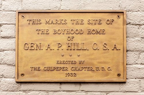
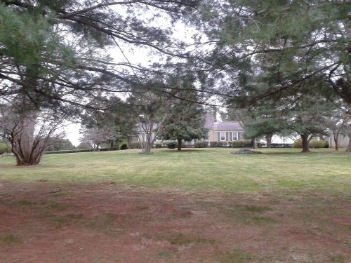
12 listings: 8 buildings, among them the A. P. Hill Boyhood Home (listed 1973, the first), 2 historic districts, the Culpeper Historic District and the South East Street Historic District, with 205 contributing buildings, and 2 sites. 218 historic buildings in all.
How old are the homes in Culpeper?
5% of Culpeper’s homes were built before 1940 (Census estimate, ±2.2 points), against a typical 1.9% for a Virginia town; the median home was built in 1998.
Founding dates: Wikidata, Wikipedia, the U.S. post office records of Blevins & Helbock (CC0) and the Census. Homes by year built: Census ACS 2020–24. National Register of Historic Places: National Park Service (list of May 22, 2026). Old photos, postcards and papers: Wikimedia Commons, the Library of Congress and other public archives, credited on each item’s page. Maps: U.S. Geological Survey historical topographic maps (via Esri) and Sanborn fire-insurance maps (Library of Congress). History text and census tables: Wikipedia (CC BY-SA 4.0). Places that used to be: USGS Geographic Names Information System (2021).
From Wikimedia Commons (2), the Library of Congress (16), the National Register of Historic Places (12), Wikipedia, Wikidata and Wikipedia for famous people, U.S. Geological Survey historical maps, U.S. Census counts (via Wikipedia), the US Post Offices dataset (Blevins & Helbock), the USGS Geographic Names Information System, Sanborn fire insurance maps (Library of Congress) and old county and town histories (Internet Archive). Archive images are copied here with their credits and licenses, shown on each photo’s page. Refreshed monthly.





 1862–1865
 1862–1865
 1862
 1863
 1863
 1863
 1863
 1863
 1863
 1863
 1863
 1863
 1863
 1863
 1863
 1863
 1863


