
Places to visit in Harrogate, led by Mercer Gallery
Among the places to visit in and near Harrogate are 3 historic houses, 3 attractions and 2 museums. There are 2 places to visit inside Harrogate’s built-up area, and 12 more within 5 km of its edge. Of these, 2 are looked after: 1 by RHS and 1 by English Heritage. Close to the centre, within 1 km, are 2 of the places on the list. Go 13 km out for Fountains Abbey.
Start with these in Harrogate
Following Mercer Gallery are 2 castles, a museum and a garden.
 Art galleryMercer Galleryin townMuseumMuseumThe Harrogate Museum at the Royal Pump Roomin town
 CastleKnaresborough Castle1.2 km outside town, to the east
 Garden · RHSRHS Garden Harlow Carr100 m outside town, to the southwest
 Castle · English HeritageSpofforth Castle4.2 km outside town, to the southeast
 Historic houseRipley Castle3.3 km outside town, to the northwest
Each has a page of its own: what it is, who runs it, the weather month by month and what else is near it.
Mapped
The map puts most of the 12 to the east.
The dashed line is Harrogate’s built-up area; orange marks its middle (where most people live). Numbers match the list below. © OpenStreetMap contributors · ONS built-up area 2022
How the list breaks down
6 castles or historic places and 3 museums or galleries top the count.
Green: inside Harrogate. Grey: within 5 km of its edge.
2 places are cared for: 1 by RHS and 1 by English Heritage (RHS Garden Harlow Carr and Spofforth Castle).
Place by place
After the 2 in town come 12 more within 5 km of its edge.
RHS Garden Harlow Carr
One of five public gardens run by the Royal Horticultural Society.
Spofforth Castle
Castle in Spofforth with Stockeld, Harrogate, North Yorkshire, England, UK.
Ripley Castle
Grade I listed castle in Ripley, North Yorkshire, England, United Kingdom.
 7
 8
Rudding Park
Grade I listed country house in Follifoot, North Yorkshire, England, UK.
 9
 12
Tudor Courthouse Museum
Museum building in Knaresborough, Harrogate, North Yorkshire, England, UK.
The 2 inside Harrogate come first, best known first; then the places within 5 km, close and well known first. Churches and listed buildings are on the History page, not here.
168 listed buildings are on Harrogate’s History page → · Parks, footpaths and green space in Harrogate →
Names further out
Fountains Abbey (13 km) leads the 12 big names within reach.
 Abbey or priory · English HeritageFountains Abbey13 km north
 Garden · National TrustStudley Royal Park14 km north
 Historic houseHarewood House11 km south
 ChurchYork Minster30 km eastMuseumBig drawMuseumNational Railway Museum29 km east · 808K visitors a year
 CathedralRipon Cathedral16 km north
 Castle · English HeritageClifford's Tower30 km east
 MuseumYorkshire Museum30 km east · 164K visitors a year (2019)
 MuseumNational Science and Media Museum27 km southwest · 442K visitors a year (2015)
 CathedralLeeds Cathedral21 km south
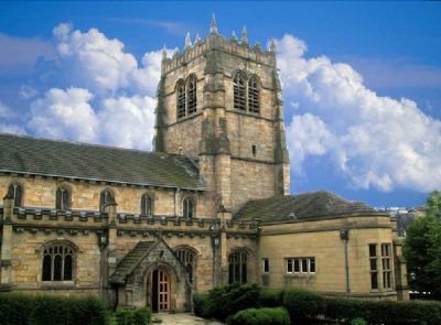 CathedralBradford Cathedral26 km southwest
 MuseumYork Castle Museum30 km east · 284K visitors a year (2013)
Places well known beyond Harrogate (Wikipedia articles in several languages, published visitor counts, or a National Trust, English Heritage or Cadw property), close and famous first. Distances are straight lines from the middle of the town.
Practical questions about Harrogate
What are the main attractions in Harrogate?
The best known inside Harrogate’s built-up area are Mercer Gallery and The Harrogate Museum at the Royal Pump Room. In all, 2 places to visit are mapped inside the town, and 12 more within 5 km.
Does Harrogate have a museum?
3 museums and galleries are in or within 5 km of Harrogate: Mercer Gallery, The Harrogate Museum at the Royal Pump Room and Tudor Courthouse Museum.
Is there a National Trust or English Heritage property near Harrogate?
Yes. In or within 5 km of Harrogate, 2 places are cared for: 1 by RHS and 1 by English Heritage (RHS Garden Harlow Carr and Spofforth Castle).
What are the best-known days out near Harrogate?
Within 40 km: Fountains Abbey (13 km), Studley Royal Park (14 km), Harewood House (11 km), York Minster (30 km).
Where are Harrogate’s historic buildings listed?
Harrogate has 168 listed buildings, 1 of them Grade I. They are on its History page, from Historic England’s list, not repeated here.
How is this list made?
From OpenStreetMap (museums, galleries, zoos, theme parks and attractions, castles, forts and abbeys, and historic houses and gardens that are open to visitors) and Wikidata (what each place is, who runs it, its website and visitor counts). A place counts for Harrogate when it is inside the ONS 2022 built-up area, and as nearby within 5 km of its edge. Opening times and prices are not shown: check the official site.
Places: OpenStreetMap (© OpenStreetMap contributors, Open Database Licence) and Wikidata (CC0), placed in the ONS 2022 built-up area (Open Government Licence v3.0). Visitor counts are the latest Wikidata gives, with their year.
Photos: each place’s Wikidata image, from Wikimedia Commons under the licence below (our copy, resized).
Photo credits (20)
- Mercer Gallery: Storye book, CC BY-SA 4.0, Wikimedia Commons
- Knaresborough Castle: Redvers, CC BY 2.0, Wikimedia Commons
- RHS Garden Harlow Carr: DS Pugh, CC BY-SA 2.0, Wikimedia Commons
- Spofforth Castle: TJBlackwell, CC BY 3.0, Wikimedia Commons
- Ripley Castle: Dposte46, Public domain, Wikimedia Commons
- Old Mother Shipton's Cave Park: Simon Cobb, CC0, Wikimedia Commons
- Rudding Park: Plucas58, CC0, Wikimedia Commons
- Goldsborough Hall: Flamewire, Public domain, Wikimedia Commons
- Tudor Courthouse Museum: Supergolden, CC BY-SA 3.0, Wikimedia Commons
- Fountains Abbey: User:Klaus with K, CC BY-SA 3.0, Wikimedia Commons
- Studley Royal Park: silver_doctor. Iain Gilmour - www.silverexpressions.co.uk, CC BY 2.0, Wikimedia Commons
- Harewood House: Sirenuk, CC BY-SA 3.0, Wikimedia Commons
- York Minster: MatzeTrier, CC BY-SA 3.0, Wikimedia Commons
- Ripon Cathedral: Diliff, CC BY-SA 3.0, Wikimedia Commons
- Clifford's Tower: Francis Place (1647-1728), Public domain, Wikimedia Commons
- Yorkshire Museum: Tim Green from Bradford, CC BY 2.0, Wikimedia Commons
- National Science and Media Museum: Chemical Engineer, CC BY-SA 4.0, Wikimedia Commons
- Leeds Cathedral: Jungpionier, CC BY-SA 3.0, Wikimedia Commons
- Bradford Cathedral: Mick Melvin, CC BY-SA 2.0, Wikimedia Commons
- York Castle Museum: Jitka Erbenová (cheva), CC BY-SA 3.0, Wikimedia Commons
Contains public sector information licensed under the Open Government Licence v3.0. Contains HM Land Registry data © Crown copyright and database right 2026. Contains OS data © Crown copyright and database right 2026 (ONS boundaries). Northern Ireland: Source: NISRA; contains Land & Property Services data and Ordnance Survey of Northern Ireland information, © Crown copyright, licensed under the Open Government Licence v3.0. Scotland: contains National Records of Scotland data, Registers of Scotland data and SEPA data, © Crown copyright / © SEPA 2025, licensed under the Open Government Licence v3.0.