 I
Public · listed 1950Clitheroe CastlePhoto: Lux01 · Public domain
 Holmes Mill, Clitheroe · Photo: Clem Rutter, Rochester, Kent · CC BY-SA 3.0
AHistory Grade
History of Clitheroe · Historic England
114 listed buildings, 1 of them Grade I
On the Historic England list, all of them stand inside Clitheroe’s built-up area, 69 for every 10,000 residents. It also has 1 scheduled monument. 32% of its homes were built before 1919. We have photos of 6 of its listed buildings and 2 old views of the town. Clitheroe grades A for history: #3 of 65 in Lancashire.
Listed buildings
114
69 per 10,000 residents
Grade I
1
exceptional interest
Grade II*
1
more than special interest
Scheduled monuments
1
1 registered park or garden
Homes built before 1919
32%
typical UK town 15%
In pictures
Clitheroe in 8 photos and old views
Nearly every Grade I and II* building, photographed, and the town before 1950. Tap a photo to step through them full screen.
 Clitheroe CastleGrade I listed
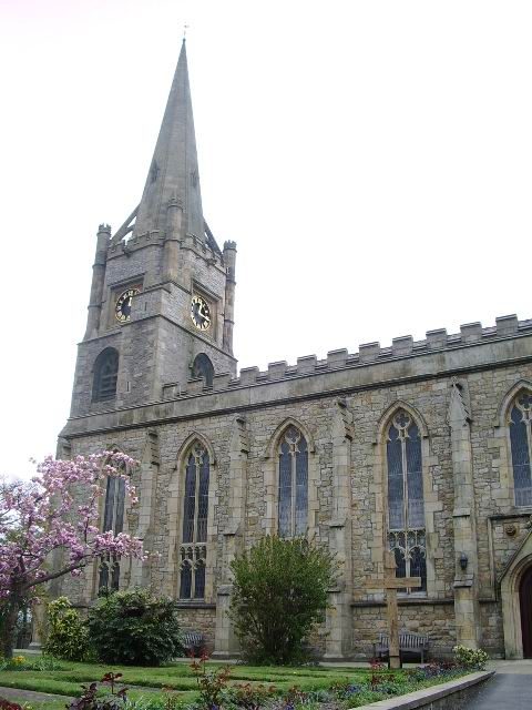 Parish Church of St Mary MagdaleneGrade II* listed
 White Lion HotelGrade II listed
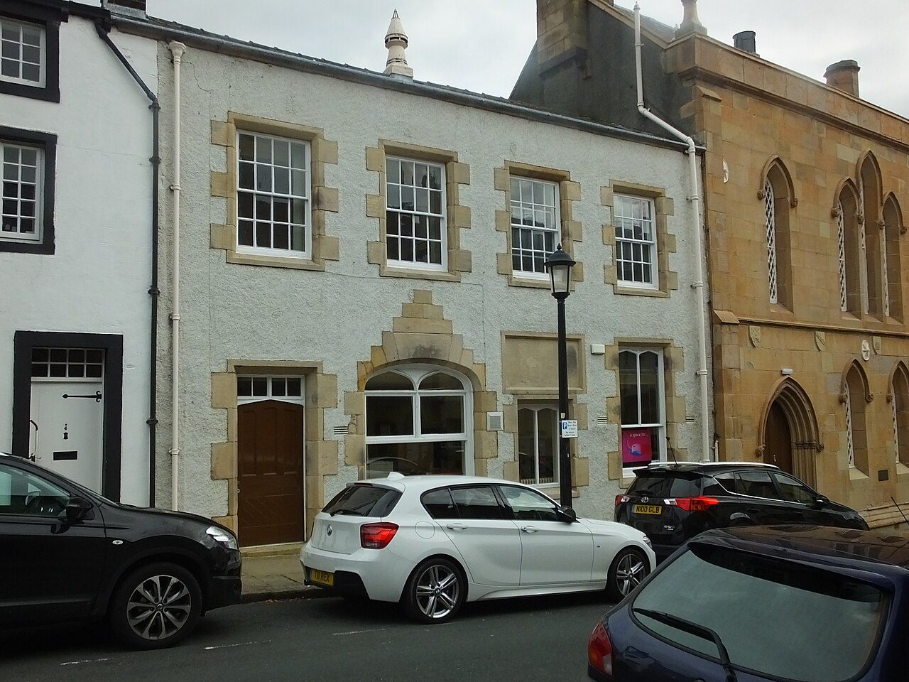 Premises Occupied by Tourist Information OfficeGrade II listed
 Town HallGrade II listed+3See all photos
Photos from Wikimedia Commons and Geograph, copied to our own server, each credited to its photographer with its licence; names open the building’s page or its official list entry.
Through time
Clitheroe from 1892 to 1892
2 old photos and postcards, in date order. All public domain, made before 1950.
 c. 1892
 c. 1892
Public domain, from Wikimedia Commons, copied to our own server. Each credit opens the image’s page with its full description and history.
The map
Where Clitheroe’s history is
Every Grade I and II* building, monument and historic park, over the age of each neighbourhood’s homes.
Grade IGrade II*Scheduled monumentPark or garden
Homes built before 1919, by neighbourhoodunder 10%10–25%25–50%50%+
2 of 10neighbourhoods have mostly pre-1919 homes; in the oldest, 80% were built before 1919.
Hover a dot for its name; tap one with a photo to open it.
114 listed buildings by grade
1 Grade I1 Grade II*112 Grade II
Historic England lists buildings in three grades: Grade I for buildings of exceptional interest (about 2.5% of all listed buildings), Grade II* for particularly important buildings of more than special interest (about 5.8%), and Grade II for buildings of special interest (about 91.7%). Listing protects the whole building, inside and out.
Every entry on the National Heritage List for England whose point lies inside the ONS 2022 built-up-area boundary. One list entry can cover a terrace or a group of buildings. Neighbourhood dots: the population-weighted centre of each Census 2021 output area, coloured by its neighbourhood’s (LSOA’s) share of homes built before 1919 (Valuation Office Agency, March 2025).
Grade I
The Grade I listed building in Clitheroe
Buildings of exceptional interest, about 2.5% of all listed buildings. Every one is photographed. Each opens its own page, with the official list entry.
Grade II*
The Grade II* listed building in Clitheroe
Particularly important buildings of more than special interest. Every one is photographed.
 II*
Church · listed 1950St Mary Magdalene's ChurchOn the list as Parish Church of St Mary MagdalenePhoto: Alexander P Kapp · CC BY-SA 2.0
Historic streets
The Castle Street and Church Street have the most listed buildings
Streets by the listed entries with an address on them. One entry can be a whole terrace, so long rows count once.
Castle Street10 listed
Church Street10 listed
Shaw Bridge Street7 listed
Moor Lane6 listed
York Street6 listed
Duck Street5 listed
Parson Lane5 listed
Market Place3 listed
Whalley Road3 listed
Of the 114 entries, 65 are named by a street address; the rest are named buildings such as churches, halls and bridges.
What’s protected
Most of Clitheroe’s listed buildings are homes
Every listed building sorted by what its list name says it is.
Houses, terraces & villas88
Public & civic buildings12
Inns, shops & warehouses10
Churches, chapels & priories3
Memorials, crosses & tombs1
88 entries (77%) are houses, terraces and villas. 3 are churches, chapels and priories.
Buildings are sorted by words in each entry’s name (church, gate, inn, memorial…): the list’s open data has no building type. An entry named only by its address counts as a house.
Grade II
112 Grade II listed buildings
Most listed buildings are in this grade, which covers buildings of special interest. Open any building to read its official list entry.
All 112 Grade II listed buildings, A to Z
Andrew Carnegie Public LibraryAshgrove Shaw CottageBrown Cow Public HouseChurch of St JamesClitheroe Royal Grammar School for Boys Old BuildingClitheroe War MemorialCommercial Hotel (Including Stable Block to Rear)Crown Inn Chambers and Numbers 3 to 7 (Odd)Dog and Partridge Public House and Number 3Former Stables to RoefieldHenthorn Farm and Henthorn Farm CottageHolmes Mill, ClitheroeHorrocksford Hall BarnK6 Telephone Kiosk Outside Premises Occupied by Yorkshire BankLittle Moor HouseLower Standen FarmhouseMajor HouseMytton House Amd Number 13New InnNos. 11 and 13, RAILWAY VIEW ROADNumber 4 and Church CourtOutbuilding and Stable Block to Clitheroe Castle and Premises Occupied by Ribble Valley Borough CouncilPart of Premises Occupied by Number 27Pimlico Farmhouse and Attached Farm BuildingPremises Occupied by Barclays BankPremises Occupied by Ceramica Italia LtdPremises Occupied by Ribble Valley Borough Council in Grounds of Clitheroe CastlePremises Occupied by Tourist Information OfficePrimrose HouseRoefieldRose and Crown HotelSaint Mary's WellSt Michael's Primary SchoolStanley HouseStanworth HouseStocks WellsSwan and Royal HotelThe AlleysThe Church of St Michael and St John and attached presbyteryThe Grand CinemaThe National BuildingsThe Old BothyThe Towns WellThe VicarageTown HallTurret from Houses of Parliament in Gardens of Clitheroe CastleWhite Lion Hotel1 and 3, Castle Gate1 and 3, Moor Lane1 and 3, Parson Lane1, Church Street1, Market Place1-9, Little Moor10, Church Street11, Castle Street11-15, Little Moor11-15, Shaw Bridge Street11-23, York Street12-16, York Street13-19 Castle Street15, Church Street16, Castle Street16, Parson Lane17, Moor Lane18 and 20, Castle Street18 and 20, Parson Lane18, York Street19, Church Street2 Church Brow2 and 4, Duck Street2, Castle Street2, Shaw Bridge Street2-6, York Street21, Church Street22 Church Street23 Church Street24 Church Street26 Castle Street26 and 28, Duck Street27 and 29, Castle Street28 and 30, Parson Lane29-33, Wellgate3 and 5, Church Street3, 5 and 5A, Market Place3-13, Duck Street3-9, Railway View Avenue30 and 32, Duck Street31 and 33, Castle Street32-36, Moor Lane32-36, Parson Lane33 and 35, Lowergate34-38, York Street39 and 41, Lowergate4, Shaw Bridge Street4-12, Castle Street4-8 Church Brow45 and 47 Whalley Road46, Moor Lane48-52, Moor Lane5, Shaw Bridge Street56-60, Moor Lane6 and 8, Church Street6, Shaw Bridge Street6-12, Duck Street7 and 9, Shaw Bridge Street7 and 9, Wellgate78-88, Whalley Road8 and 10, Shaw Bridge Street8 and 10, York Street9, Castle Street9, Market Place90-110, Whalley Road
Conservation areas
1 conservation area covers 6.4% of Clitheroe
Areas the council protects as a whole: demolition and changes to how buildings look need consent, and trees are protected.
Clitheroe 197332 ha
32 hain conservation areas, of 493 ha inside the built-up area.
97 of the 114 listed buildings stand in one.
Historic England’s conservation areas layer, supplied by councils (incomplete in places, so a page fact, never graded). Hectares are the part of each area inside the built-up area.
How the list grew
More than half of Clitheroe’s listed buildings were added in one year, 1976
The year each building now on the list was first listed.
1976 · 821950 · 25
19501960197019801990200020102020
The first 25 entries were listed in 1950, 1 of the 1 Grade I buildings among them. 82 came in 1976, in the national resurvey of the 1970s and 80s. Only 3 have been added in the last 15 years.
Monuments & landscapes
Monuments, parks and gardens
Designations that overlap the town by a tenth of their area or half a hectare.
1 scheduled monument
Nationally important archaeological sites and monuments, protected by law; work on them needs consent from the Secretary of State, advised by Historic England.
1 registered park or garden
Clitheroe CastleGrade II
History Grade
Clitheroe grades A for history
Protected heritage and the age of the town’s homes, against all UK towns.
Protected heritage, for its size and in all (120 points, 72 per 10,000 residents)More than 75% of UK towns
Homes built before 1919 (32%)More than 87% of UK towns
Two measures, each ranked against every UK town of 1,000 or more, with protected heritage counting twice as much as the age of homes. Protected heritage counts each listed building by its grade (Grade I three points, II* two, II one), each scheduled monument and battlefield two, and each registered park or garden by its grade; it is ranked both per 10,000 residents and as a total, so a village with one fine church doesn’t outrank a historic city. The second measure is the share of homes built before 1919, from the Valuation Office Agency’s council tax records. History is a character grade: it describes the town and isn’t part of the overall grade.
Homes by age
32% of Clitheroe’s homes were built before 1919
Every home by when it was built, from council tax records, against England & Wales (the dark tick).
28%
Before 1900
3.8%
1900–18
3.9%
1919–29
3.8%
1930s
5.9%
1945–54
8.7%
1955–64
4.7%
1965–72
5.4%
1973–82
3.6%
1983–92
8.9%
1993–99
2.7%
2000–08
3.5%
2009–15
17%
2016–25
ClitheroeEngland & Wales
28% of homes are Victorian or older, against 16% across England and Wales. The busiest period since was 2016–25, which added 17% of today’s homes.
Valuation Office Agency, council tax stock of properties by build period, 31 March 2025, for the neighbourhoods (LSOAs) that make up the town, split by where their residents live. Homes with no recorded build period (148 here) are left out; 1939–44 is not a period in the data.
Born here
11 notable people born in Clitheroe before 1900
Their lives on one timeline, earliest first.
James King
James Burton
John Brogden
James Simpson (Bible Christian)
Benjamin Dean
James Oddie
Robert Bulcock
Frederic T. Greenhalge
Jack Keenan
Dick Harrison
Jimmy Crabtree
175017751800182518501875190019251950

Frederic T. Greenhalge1842–1896 · American politician (1842-1896)

James King1750–1784 · Officer of the Royal Navy; served under James Cook (1750-1784)

Benjamin Dean1824–1897 · American politician in Massachusetts (1824-1897)
DH
Dick Harrison1881– · Cricketer (1881-?)
JK
Jack Keenan1864–1906 · English footballer (1864-1906)
JC
Jimmy Crabtree1895–1965 · British association football player (1895-1965)
JB
James Burton1784–1868 · British millowner
JB
John Brogden1798–1869 · British railway contractor and promoter (1798-1869)
Everyone born in Clitheroe → Birthplaces from Wikidata; portraits from Wikimedia Commons.
Towns its size
Clitheroe has the 102nd most Grade I buildings of 517 towns its size
Places of 10,000–27,000 people outside London, by Grade I listed buildings.
Neighbours
Listed buildings in the places around Clitheroe
| Town | People | Listed | Grade I | History |
|---|---|---|---|---|
| Clitheroe | 16,626 | 114 | 1 | A |
| Waddington | 1,005 | 17 | 0 | A− |
| Barrow | 1,388 | 0 | 0 | D |
| Chatburn | 1,125 | 6 | 0 | B |
| Whalley | 3,411 | 25 | 3 | B+ |
| Sabden | 1,582 | 2 | 0 | C+ |
| Billington | 1,743 | 0 | 0 | D |
| Old Langho | 1,072 | 1 | 1 | C |
In brief
Clitheroe in brief
More of Clitheroe’s homes are old than in most places: 32% were built before 1919, against 15% in the typical UK town. All told, the list holds 114 listed buildings, 1 of them Grade I, including Clitheroe Castle. For its size, it has more listed heritage than 75% of UK towns. Only 101 of the 517 towns nearest its size have more Grade I buildings.
Castle Street alone has 10 listed buildings. A conservation area has protected part of it since 1973. Most entries on the list, 77%, are houses, terraces and villas. Beyond that, it also has a scheduled monument.
Questions about Clitheroe’s history
How many listed buildings are there in Clitheroe?
Historic England lists 114 buildings inside Clitheroe’s built-up area: 1 Grade I, 1 Grade II* and 112 Grade II.
What are the Grade I listed buildings in Clitheroe?
One: Clitheroe Castle.
Which street in Clitheroe has the most listed buildings?
Castle Street (10), Church Street (10) and Shaw Bridge Street (7) have the most listed entries named by an address. One entry can be a whole terrace.
Are there scheduled monuments in Clitheroe?
Yes, 1 scheduled monument, including Clitheroe Castle; medieval enclosure castle.
How many conservation areas are there in Clitheroe?
1, covering about 32 hectares of the town. The largest is Clitheroe.
When were Clitheroe’s buildings listed?
The first in 1950; the most, 82, in 1976.
Are there old photos of Clitheroe?
Yes: 2 public-domain photos and postcards from 1892 to 1892, all on this page.
Who was born in Clitheroe?
Among people born before 1900: Frederic T. Greenhalge (1842), James King (1750), Benjamin Dean (1824), Dick Harrison (1881) and Jack Keenan (1864).
How old are the homes in Clitheroe?
32% of homes were built before 1919 and 40% before 1940, from the Valuation Office Agency’s council tax records (March 2025).
© Historic England 2026. Contains Ordnance Survey data © Crown copyright and database right 2026. The National Heritage List for England is the official, up-to-date register of all nationally protected historic buildings and sites in England; check an entry on Historic England’s website before relying on it.
Sources: Historic England, National Heritage List for England (listed buildings, scheduled monuments, registered parks and gardens, battlefields, World Heritage Sites), October 2026, inside the ONS 2022 built-up-area boundary · Valuation Office Agency, Council Tax: stock of properties by build period (31 March 2025) · TownRatings grades: our own summary of the data, ranked against UK towns only · Historic England conservation areas (supplied by local planning authorities; October 2026). All under the Open Government Licence v3.0.
Contains public sector information licensed under the Open Government Licence v3.0. Contains HM Land Registry data © Crown copyright and database right 2026. Contains OS data © Crown copyright and database right 2026 (ONS boundaries). Northern Ireland: Source: NISRA; contains Land & Property Services data and Ordnance Survey of Northern Ireland information, © Crown copyright, licensed under the Open Government Licence v3.0. Scotland: contains National Records of Scotland data, Registers of Scotland data and SEPA data, © Crown copyright / © SEPA 2025, licensed under the Open Government Licence v3.0.