 I
Public · listed 1969Totnes CastleOn the list as The CastlePhoto: Pymouss · CC BY-SA 4.0
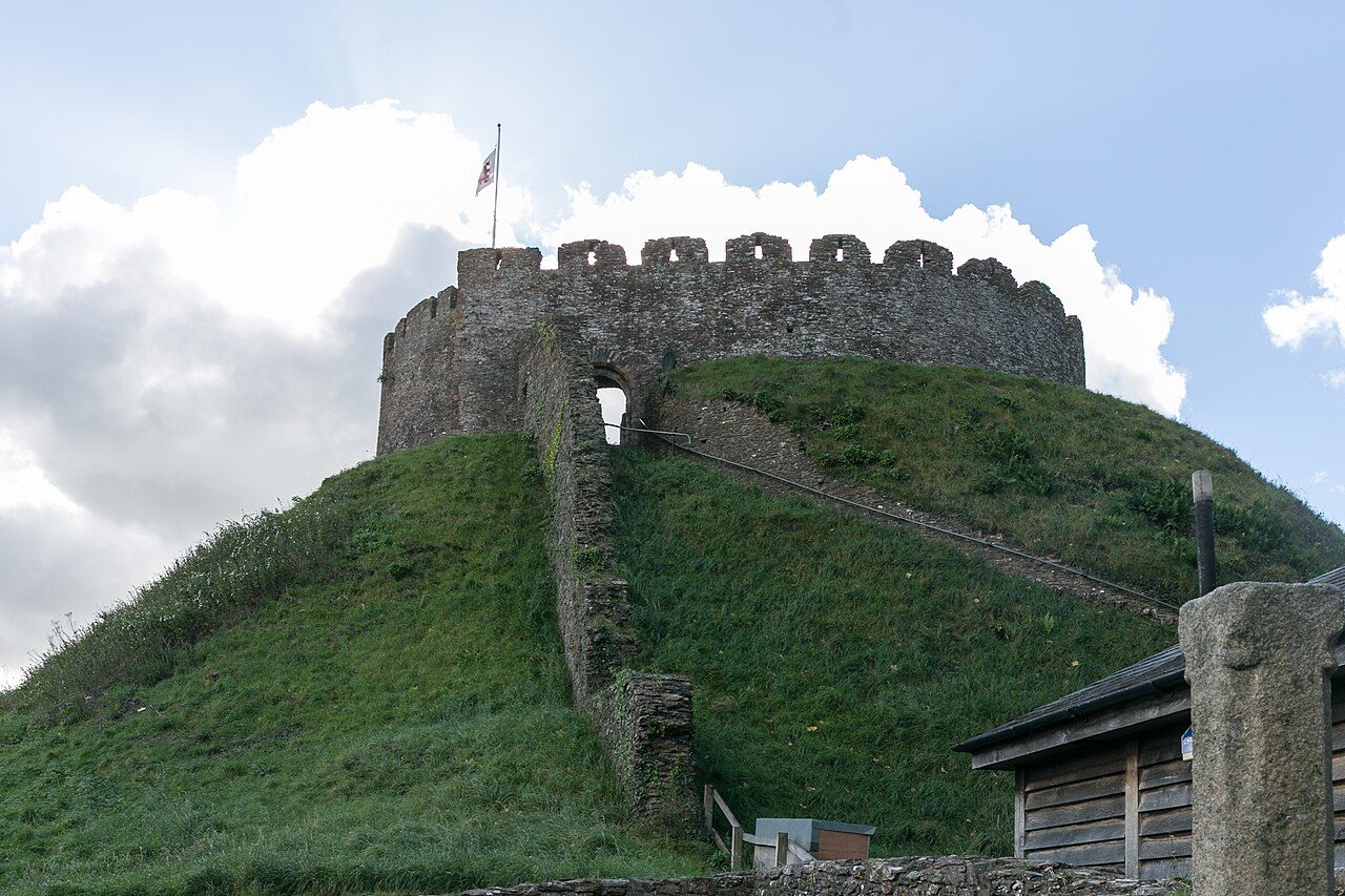 The Castle · Photo: Pymouss · CC BY-SA 4.0
A+History Grade
History of Totnes · Historic England
314 listed buildings, 6 of them Grade I
Historic England counts them inside Totnes’s built-up area, 341 for every 10,000 residents. It also has 5 scheduled monuments. 25% of its homes were built before 1919. We have photos of 33 of its listed buildings and 4 old views of the town. Totnes grades A+ for history: #5 of 47 in Devon.
Listed buildings
314
341 per 10,000 residents
Grade I
6
exceptional interest
Grade II*
26
more than special interest
Scheduled monuments
5
nationally important sites
Homes built before 1919
25%
typical UK town 15%
In pictures
Totnes in 37 photos and old views
Nearly every Grade I and II* building, photographed, and the town before 1950. Tap a photo to step through them full screen.
 Elizabethan House and Local MuseumGrade I listed
 Church of St MaryGrade I listed
 Holmans WarehouseGrade II listed
 Seymour HotelGrade II listed
 Guildhall CottageGrade II listed+32See all photos
Photos from Wikimedia Commons and Geograph, copied to our own server, each credited to its photographer with its licence; names open the building’s page or its official list entry.
Through time
Totnes from 1866 to 1890
4 old photos and postcards, in date order. All public domain, made before 1950.
 1866
 1890
 1890
 1890
Public domain, from Wikimedia Commons, copied to our own server. Each credit opens the image’s page with its full description and history.
The map
Where Totnes’s history is
Every Grade I and II* building, monument and historic park, over the age of each neighbourhood’s homes.
Grade IGrade II*Scheduled monument400 m from Totnes Castle
Homes built before 1919, by neighbourhoodunder 10%10–25%25–50%50%+
6 of 6Grade I buildings stand within 400 m of Totnes Castle, a five-minute walk. So do 206 of the 314 listed buildings.
1 of 6neighbourhoods have mostly pre-1919 homes; in the oldest, 59% were built before 1919.
Hover a dot for its name; tap one with a photo to open it.
314 listed buildings by grade
6 Grade I26 Grade II*282 Grade II
Historic England lists buildings in three grades: Grade I for buildings of exceptional interest (about 2.5% of all listed buildings), Grade II* for particularly important buildings of more than special interest (about 5.8%), and Grade II for buildings of special interest (about 91.7%). Listing protects the whole building, inside and out.
Every entry on the National Heritage List for England whose point lies inside the ONS 2022 built-up-area boundary. One list entry can cover a terrace or a group of buildings. Neighbourhood dots: the population-weighted centre of each Census 2021 output area, coloured by its neighbourhood’s (LSOA’s) share of homes built before 1919 (Valuation Office Agency, March 2025).
Grade I
The 6 Grade I listed buildings in Totnes
Buildings of exceptional interest, about 2.5% of all listed buildings; 6 of these stand within 400 m of Totnes Castle. Every one is photographed. Each opens its own page, with the official list entry.
 I
Public · listed 1952Totnes MuseumOn the list as Elizabethan House and Local MuseumPhoto: Pymouss · CC BY-SA 4.0
 I
Church · listed 1952Church of St MaryPhoto: Wigulf · CC BY 2.5
 I
House · listed 1952EastgateOn the list as Eastgate (Part of No 2)Photo: Pymouss · CC BY-SA 4.0
 I
Public · listed 1952Totnes GuildhallOn the list as The GuildhallPhoto: Pymouss · CC BY-SA 4.0
 I
House · listed 195243, ButterwalkPhoto: Chris Denny · CC BY-SA 2.0
Grade II*
The 26 Grade II* listed buildings in Totnes
Particularly important buildings of more than special interest. 24 are photographed.
 II*
Church · listed 1952Church HousePhoto: Simon Cobb · CC0
 II*
House · listed 1952Eastgate HousePhoto: Simon Cobb · CC0
 II*
House · listed 1952Follaton HouseOn the list as Follaton House (South Hams District Council)Photo: Richard Knights · CC BY-SA 2.0
 II*
Public · listed 1952King Edward VI SchoolPhoto: Pymouss · CC BY-SA 4.0
 II*
House · listed 1969Nos 34, 34A and 34B (Flat)Photo: Simon Cobb · CC0
 II*
Walls & gates · listed 1952Priory Gate HousePhoto: Simon Cobb · CC0
 II*
Inns & shops · listed 1952The Royal Seven Stars HotelPhoto: Rob Purvis · CC BY-SA 2.0
 II*
House · listed 195210, 10A and 10B, High StreetPhoto: Simon Cobb · CC0
 II*
House · listed 197810, WarlandPhoto: Simon Cobb · CC0
 II*
House · listed 195216 High StreetPhoto: Pymouss · CC BY-SA 4.0
 II*
House · listed 196922, High StreetPhoto: Pymouss · CC BY-SA 4.0
 II*
House · listed 195226, High StreetPhoto: Simon Cobb · CC0
Show the other 14
 II*
House · listed 195228, High StreetPhoto: Simon Cobb · CC0
 II*
House · listed 195232, High StreetPhoto: Simon Cobb · CC0
 II*
House · listed 195233, High StreetPhoto: Simon Cobb · CC0
 II*
House · listed 195239 and 41, High StreetPhoto: Simon Cobb · CC0
 II*
House · listed 195248, Fore StreetPhoto: Simon Cobb · CC0
 II*
House · listed 195250, Fore StreetPhoto: Simon Cobb · CC0
 II*
House · listed 195252, Fore StreetPhoto: Simon Cobb · CC0
House · listed 195254, Fore StreetPhoto: Simon Cobb · CC0
 II*
House · listed 195255, High StreetPhoto: Pymouss · CC BY-SA 4.0
 II*
House · listed 195264, Fore StreetPhoto: Simon Cobb · CC0
 II*
House · listed 195268, Fore StreetPhoto: Phil Gayton from Totnes, UK · CC BY 2.0
 II*
House · listed 19528, High StreetPhoto: Pymouss · CC BY-SA 4.0
House · listed 1981Outbuilding to Rear of No 39 (Former Kitchen Block)
Church · listed 1952Priory House
Historic streets
High Street has the most listed buildings
Streets by the listed entries with an address on them. One entry can be a whole terrace, so long rows count once.
High Street70 listed · 10 II*


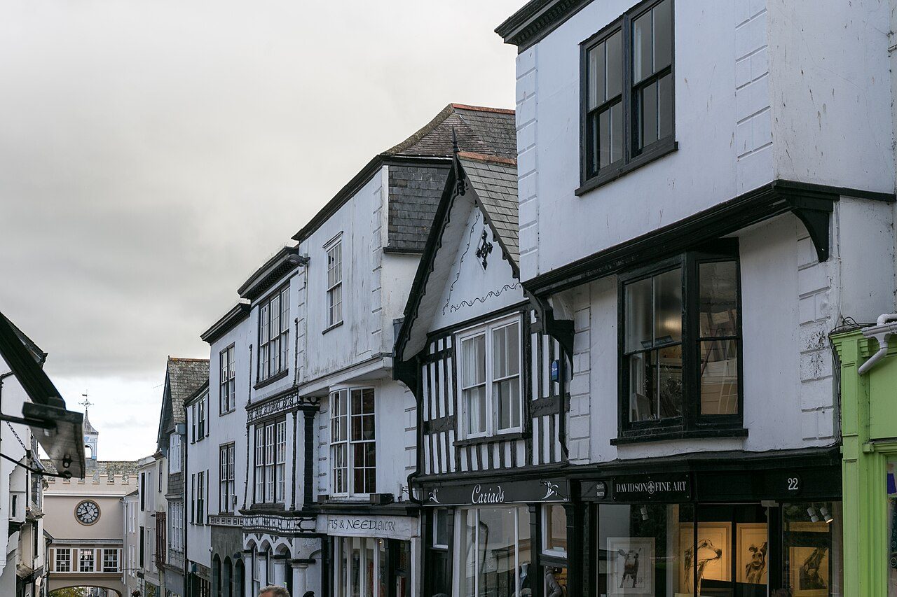
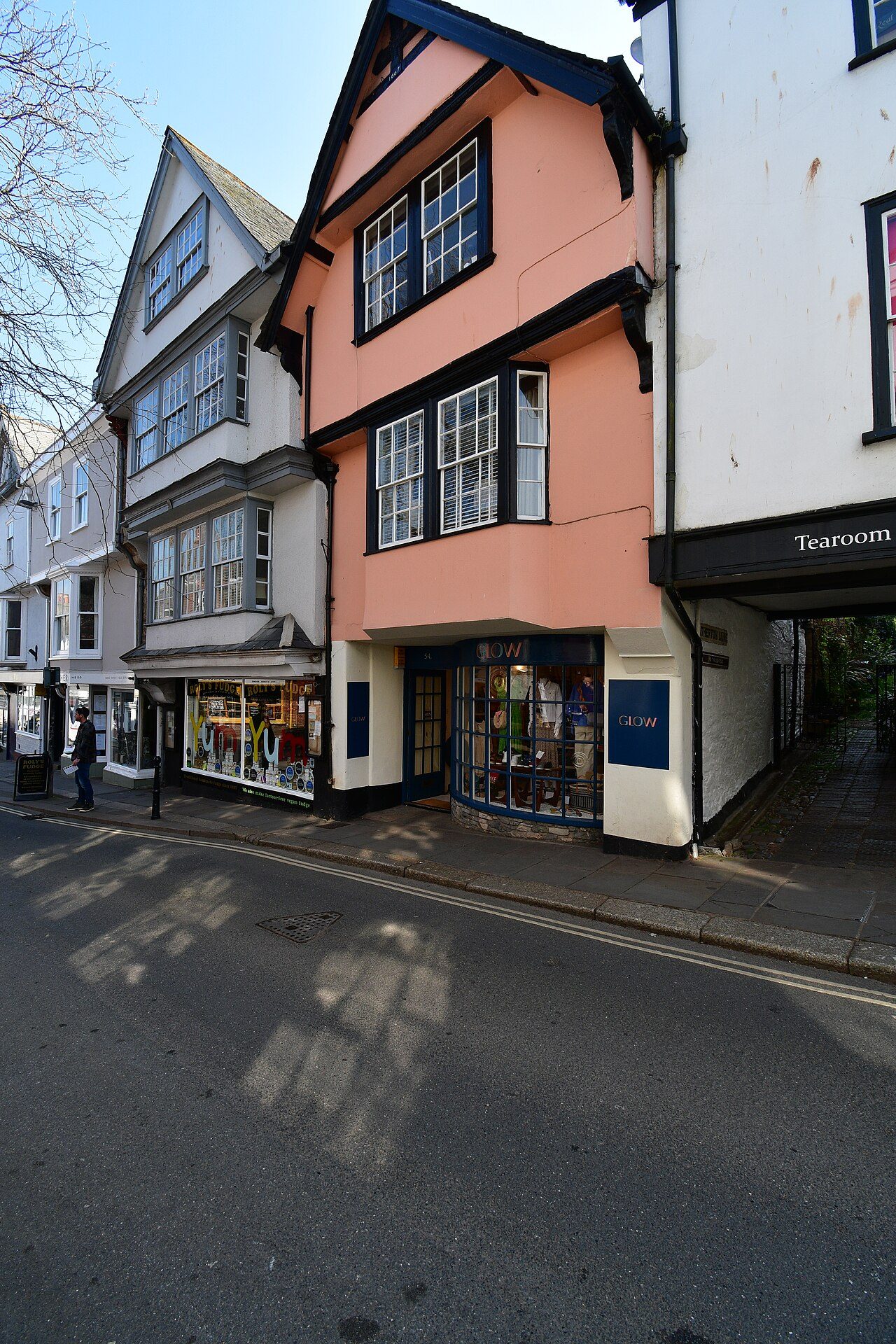
Fore Street39 listed · 6 II*


Bridgetown12 listed
Castle Street9 listed
Leechwell Street8 listed
South Street7 listed
Warland7 listed · 1 II*

The Plains5 listed
Of the 314 entries, 179 are named by a street address; the rest are named buildings such as churches, halls and bridges.
What’s protected
Most of Totnes’s listed buildings are homes
Every listed building sorted by what its list name says it is.
Houses, terraces & villas264
Inns, shops & warehouses19
Public & civic buildings10
Walls, gates & bridges9
Churches, chapels & priories7
Street furniture3
Memorials, crosses & tombs2
264 entries (84%) are houses, terraces and villas. 7 are churches, chapels and priories, including 1 of the 6 Grade I buildings.
Buildings are sorted by words in each entry’s name (church, gate, inn, memorial…): the list’s open data has no building type. An entry named only by its address counts as a house.
Grade II
282 Grade II listed buildings
Most listed buildings are in this grade, which covers buildings of special interest. Open any building to read its official list entry.
The first 150 of 282 Grade II listed buildings, A to Z
Albert InnAshleigh VillasBaste WallsBay Cottage Bay VillaBay Horse InnBirdwood CottageBirdwood HouseBlue Coat HouseBollard Opposite No 1Brutus Stone to Front of Nos 51/53Bull InnCastle HotelCastle HouseChurch of St JohnChurchyard Wall and Gates of St Mary's Priory ChurchColdharbour CottagesCosy Cot Lamb CornerCottage FarmDart Bank Cottage, Josam Dor and Riverwatch, 1-3 St Peter's TerraceDart Vale HouseDartmouth InnDartvale ManorDevon County Council Welfare CentreDevon PlaceDuncliffe and Strathmore, Pomeroy VillasEastgateEglensElbow Room RestaurantElm ViewElwellEntrance Gateway of RosemountEntrance and Passage Adjoining No 4 (Archway House) and Leading to Jasmin Cottage and Tower ViewFairfield Little Meadow Cottage Meadow HouseFernleigh and Fernleigh Cottage, Pomeroy VillasFollaton LodgeFormer Methodist ChapelGothic HouseGothic LodgeGrenvilleGuildhall CottageHarris Bacon Factory Building at Town MillsHaytorHermitageHighfieldHolmans WarehouseHope HouseHouse at Rear of No 19 High StreetIveliJasmin CottageJerusalemK6 Telephone KioskKingsbridge InnLamp Post Outside No 9LeechwellLion HouseLittle PrioryLloyds BankLloyds Bank LimitedLock Up Immediately North of the Old Forge Guest HouseLower BroomboroughManor CottageManor HouseMarlborough LodgeMiddletonMidland BankMidway HouseMount PleasantMount Plym HotelNarrows HouseNational Westminster BankNorthcote RosemountNorthgateNorthgate LodgeNos 53A and 55A (Flats)Outhouse to South East of Lower BroomboroughOxford ArmsPair of Warehouses Immediately North of Alpha TerraceParadise HousePlym HousePlym VillasPlymouth Inn HousePuddavine CottageRear Gateway of No 2 from South Street Rear Gateway of No 2 High StreetSefton HouseSeymour CottageSeymour HotelSeymour LodgeSeymour TerraceSeymour VillasSouth Hams District CouncilSouth Wall HouseStable CottageSteam Packet InnSteps CottageThe LambThe Obelisk in Memory of John WillsThe Old Cider FactoryThe Old South Range of HospitalThe Old Ticket Office Including Steps, Wall and Railings Adjoining EastThe Post OfficeThe Priory Gateway and Flanking Walls Adjoining East of Priory CottagesThe Pumping StationThe Quaker HouseThe WickTotnes Cemetery LodgeTotnes Cemetery Mortuary ChapelTotnes HouseTotnes Signal BoxTotnes War MemorialTower View at Rear of No 20Town Mills (Part of Harris's Bacon Factory)Town Wall (Rear Curtilage Wall of No 2) Town Wall (South West of and Adjoining No 1)Two Granite PillarsWarehouse (Graham Reeves) on East Side of Steam Packet InnWarland HouseWaterloo PlaceWaterman's Arms Public HouseWesthill CottageWinsland HouseWorkshop at Rear of 97 High StreetWrinklehorn1 Fore Street, And 1A and 1B Mill Lane1 and 2, Weston Road1, Bank Lane1, Blue Ball Hill1, Bridgetown1, Castle Street1, High Street1, Leechwell Lane1, New Walk1, Ticklemore Street1, Warland1-10, Seymour Place1-12, Plymouth Road1-18, Moorashes1-3, The Plains1-6, Orchard Terrace10, Fore Street10, Leechwell Street10, South Street10-12, Victoria Street10-13, Castle Street101, High Street103 and 103A, High Street105, High Street107, High Street11 and 12, The Plains11, Cistern Street12, High Street12, Warland
Conservation areas
1 conservation area covers 100% of Totnes
Areas the council protects as a whole: demolition and changes to how buildings look need consent, and trees are protected.
No data available for publication by HE280 ha
280 hain conservation areas, of 280 ha inside the built-up area.
314 of the 314 listed buildings stand in one.
Historic England’s conservation areas layer, supplied by councils (incomplete in places, so a page fact, never graded). Hectares are the part of each area inside the built-up area.
How the list grew
143 of Totnes’s 314 listed buildings were added in 1978
The year each building now on the list was first listed.
1978 · 1431969 · 851952 · 66
19501960197019801990200020102020
The first 66 entries were listed in 1952, 5 of the 6 Grade I buildings among them. 143 came in 1978, in the national resurvey of the 1970s and 80s. Only 2 have been added in the last 15 years.
Monuments & landscapes
Monuments, parks and gardens
Designations that overlap the town by a tenth of their area or half a hectare.
5 scheduled monuments
Nationally important archaeological sites and monuments, protected by law; work on them needs consent from the Secretary of State, advised by Historic England.

History Grade
Totnes grades A+ for history
Protected heritage and the age of the town’s homes, against all UK towns.
Protected heritage, for its size and in all (362 points, 393 per 10,000 residents)More than 96% of UK towns
Homes built before 1919 (25%)More than 73% of UK towns
Two measures, each ranked against every UK town of 1,000 or more, with protected heritage counting twice as much as the age of homes. Protected heritage counts each listed building by its grade (Grade I three points, II* two, II one), each scheduled monument and battlefield two, and each registered park or garden by its grade; it is ranked both per 10,000 residents and as a total, so a village with one fine church doesn’t outrank a historic city. The second measure is the share of homes built before 1919, from the Valuation Office Agency’s council tax records. History is a character grade: it describes the town and isn’t part of the overall grade.
Homes by age
25% of Totnes’s homes were built before 1919
Every home by when it was built, from council tax records, against England & Wales (the dark tick).
23%
Before 1900
1.7%
1900–18
0.4%
1919–29
11%
1930s
8%
1945–54
3.8%
1955–64
7.2%
1965–72
9.4%
1973–82
13%
1983–92
6.3%
1993–99
3.6%
2000–08
3.6%
2009–15
9.5%
2016–25
TotnesEngland & Wales
23% of homes are Victorian or older, against 16% across England and Wales. The busiest period since was 1983–92, which added 13% of today’s homes.
Valuation Office Agency, council tax stock of properties by build period, 31 March 2025, for the neighbourhoods (LSOAs) that make up the town, split by where their residents live. Homes with no recorded build period (21 here) are left out; 1939–44 is not a period in the data.
Born here
7 notable people born in Totnes before 1900
Their lives on one timeline, earliest first.
John Blackaller
Edward Lye
Sydney Dacres
Charles Hillyar
Frederick Holberton
William John Wills
H. H. Couzens
1500165018001950

William John Wills1834–1861 · British surveyor (1834–1861)

Edward Lye1694–1767 · English priest

Sydney Dacres1805–1884 · Officer of the British Royal Navy (1805-1884)
CH
Charles Hillyar1817–1888 · British Royal Navy admiral (1817-1888)
JB
John Blackaller1494–1563 · Merchant and politician from Exeter, England

Frederick Holberton1821–1907 · Member of the Queensland Legislative Assembly & Queensland Legislativ…

H. H. Couzens1877–1944 · British electrical engineer (1877–1944)
Everyone born in Totnes → Birthplaces from Wikidata; portraits from Wikimedia Commons.
Towns its size
Totnes has the 14th most Grade I buildings of 697 towns its size
Places of 6,000–15,000 people outside London, by Grade I listed buildings.
Totnes6
#13 of 697for listed buildings per resident (341 per 10,000). Brecon, Malmesbury and Ludlow lead.
13 have more. The typical town its size has 0.
Neighbours
Listed buildings in the places around Totnes
| Town | People | Listed | Grade I | History |
|---|---|---|---|---|
| Totnes | 9,217 | 314 | 6 | A+ |
| Stoke Gabriel | 1,340 | 16 | 1 | A− |
| Marldon | 2,073 | 13 | 1 | C+ |
| Ipplepen | 2,150 | 30 | 1 | A− |
| Paignton | 67,509 | 207 | 1 | B+ |
| Buckfastleigh | 2,720 | 83 | 0 | A+ |
| Denbury | 1,482 | 15 | 1 | A− |
| Abbotskerswell | 1,182 | 28 | 0 | B+ |
In brief
Totnes in brief
For its size, Totnes has more listed heritage than 96% of UK towns. In all there are 314 listed buildings, 6 of them Grade I. Of its homes, 25% were built before 1919, against 15% in the typical UK town. Totnes Castle sits at the heart of it all, with 6 of the town’s Grade I buildings within 400 m.
Only 13 of the 697 towns nearest its size have more Grade I buildings. On High Street alone there are 70 listed buildings. A conservation area protects part of it.
Questions about Totnes’s history
How many listed buildings are there in Totnes?
Historic England lists 314 buildings inside Totnes’s built-up area: 6 Grade I, 26 Grade II* and 282 Grade II.
What are the Grade I listed buildings in Totnes?
6, including Church of St Mary, Eastgate (Part of No 2), Elizabethan House and Local Museum, The Castle, The Guildhall and 43, Butterwalk.
Which street in Totnes has the most listed buildings?
High Street (70), Fore Street (39) and Bridgetown (12) have the most listed entries named by an address. One entry can be a whole terrace.
Are there scheduled monuments in Totnes?
Yes, 5 scheduled monuments, including Immersion bath associated with Leechwell holy well, 40m north east of Leechwell Cottage, Leechwell holy well, 350m south west of St Mary's Church, Medieval chapel of the Holy Ghost and St Katherine at Warland, 250m south west of Totnes Bridge and Totnes Castle.
How many conservation areas are there in Totnes?
1, covering about 280 hectares of the town. The largest is No data available for publication by HE.
When were Totnes’s buildings listed?
The first in 1952; the most, 143, in 1978.
Are there old photos of Totnes?
Yes: 4 public-domain photos and postcards from 1866 to 1890, all on this page.
Who was born in Totnes?
Among people born before 1900: William John Wills (1834), Edward Lye (1694), Sydney Dacres (1805), Charles Hillyar (1817) and John Blackaller (1494).
How old are the homes in Totnes?
25% of homes were built before 1919 and 36% before 1940, from the Valuation Office Agency’s council tax records (March 2025).
© Historic England 2026. Contains Ordnance Survey data © Crown copyright and database right 2026. The National Heritage List for England is the official, up-to-date register of all nationally protected historic buildings and sites in England; check an entry on Historic England’s website before relying on it.
Sources: Historic England, National Heritage List for England (listed buildings, scheduled monuments, registered parks and gardens, battlefields, World Heritage Sites), October 2026, inside the ONS 2022 built-up-area boundary · Valuation Office Agency, Council Tax: stock of properties by build period (31 March 2025) · TownRatings grades: our own summary of the data, ranked against UK towns only · Historic England conservation areas (supplied by local planning authorities; October 2026). All under the Open Government Licence v3.0.
Contains public sector information licensed under the Open Government Licence v3.0. Contains HM Land Registry data © Crown copyright and database right 2026. Contains OS data © Crown copyright and database right 2026 (ONS boundaries). Northern Ireland: Source: NISRA; contains Land & Property Services data and Ordnance Survey of Northern Ireland information, © Crown copyright, licensed under the Open Government Licence v3.0. Scotland: contains National Records of Scotland data, Registers of Scotland data and SEPA data, © Crown copyright / © SEPA 2025, licensed under the Open Government Licence v3.0.