Guest, Sign inJoin

Post to Waxahachie

We’ll email a one-tap link to publish your post. No password, and nothing is public until you click it.
Already a member? Sign in
Ellis County Courthouse (1 of 1)Photo: Renelibrary · CC BY-SA 4.0
BHistory
History · Waxahachie

Waxahachie’s post office opened in 1850, and 75 of its places are on the National Register

More historic than 61% of U.S. towns · #93 of 642 in Texas. What drives it

Most of Waxahachie was built recently: 7% of its homes predate 1940 and the median home dates from 2004. 75 places in town are on the National Register, among them seven historic districts with 306 buildings between them. Below: 4 old photos and papers, maps from 1885 on, and the census since 1880.

1850first post office
75on the National Register
7%homes built before 1940
4old photos & papers
19famous people
From Waxahachie’s archive · credits on each photo
Quick answers

How Waxahachie began

When was Waxahachie founded?

1850

The Waxahachie post office opened in 1850, the earliest record of the town by name. Another post office, Sterrett (1890), opened inside today’s city and later closed.

First census: 1,354 in 18802020 census: 41,140176 years

How historic is Waxahachie?

B

More historic than 61% of U.S. towns, on its age, its old homes and the National Register.

What drives the grade ↓
Founding year: the first Waxahachie post office (Blevins & Helbock, CC0).The full story ↓
History grade

What drives Waxahachie’s History grade

On its age, its old homes and the National Register, Waxahachie is more historic than 61% of U.S. towns, #93 of 642 in Texas. Its National Register listings hold the grade up; its share of homes from before 1940 pulls it down.

B
HistoryA character grade: shown, never part of Waxahachie’s overall grade.
All U.S. towns we grade (21,289)Ahead of 61%
NewerOlder
Texas towns of 2,500+ (642)Ahead of 86%

Few Texas towns list much on the Register (a typical Texas town has 0.0 per 10,000 residents, the U.S. 2.4), so Waxahachie’s 84.2 sits above most of its state (95% of Texas towns have fewer) while its 382 historic buildings outnumber those of 96% of U.S. towns.

How sure. Graded on any two of the three inputs instead, the letter would range from C to B+. The pre-1940 share (±1.5 points) is firm at this size. The founding year is the first post office, not a stated founding date.

Founding year: the first post office (other dates in Quick answers). Homes: Census ACS 2020–24. National Register: National Park Service, May 2026 list; each listing counted once (boundary changes and added documentation belong to their listing), and a historic district counts its contributing buildings. How TownRatings grades history →

What stands out about Waxahachie’s past

Read from the archive, the National Register and the record. The page puts what stands out first.

★ What stands out · On the National Register

75 listings protect 382 historic buildings

The country’s official list of buildings and places worth saving.

places listed
75
National Historic Landmarks
0
none yet
historic buildings protected
382
each building in a district counts
first listed
1974
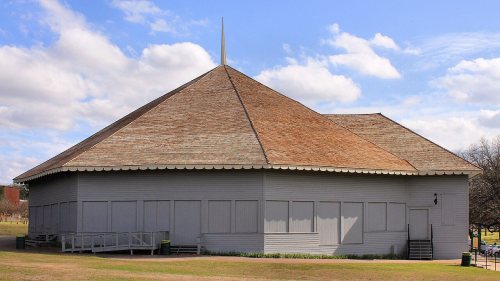
Waxahachie Chautauqua Building
Waxahachie Chautauqua BuildingEllis County Courthouse Historic DistrictWilliams-Erwin HouseRosemont HouseStrickland-Sawyer HouseBuilding at 441 East MainCole-Hipp HouseD. H. Thompson HouseDr. L. H. Graham HouseE. F. Phillips HouseE. M. Hines House, built 1895F. R. Adamson HouseGeorge C. Dillon HouseHouse at 106 KaufmanHouse at 111 BrownHouse at 111 WilliamsHouse at 1423 SycamoreHouse at 301 TurnerHouse at 320 East MarvinHouse at 418 North CollegeHouse at 501 North GrandHouse at 512 North GrandHouse at 523 HighlandHouse at 700 South RogersHouse at 712 East MarvinHouse at 803 CantrellJ. D. Kirven HouseJ. M. Alderdice HouseJ. R. Erwin HouseJ. S. Berry HouseJoe Cohn HouseJoshua Chapel A.M.E. ChurchJudge M. B. Templeton HouseM. B. Ray HouseMarshall T. Patrick HouseMary Ralston HouseMcCartney HouseO. B. Sims HouseOldham, Mary and Frank HouseOscar H. Chapman HouseParis Q. Rockett HousePat Witten HousePorter L. Williams HouseRoy Connally HouseSaint Paul's Episcopal ChurchSamuel Langsford HouseT. J. Bullard HouseW. B. Moore HouseW. B. Reinmiller HouseWest End Historic DistrictWilliam Lewis HouseRichard Vickery HouseCentral Presbyterian ChurchWaxahachie Lumber CompanyFerris SchoolHighway GarageBuilding at 500-502 East MainHouse at 104 KaufmanHouse at 113 East RossHouse at 625 CantrellHouse at 703 South CollegeHouse at 816 CantrellHouse at 901 CantrellM. S. Payne HouseNorth Rogers Street Historic DistrictOldham Avenue Historic DistrictPaillet HousePlumhoff HouseTrippet-Shive HouseWilliam Koger HouseWyatt Street Shotgun House Historic DistrictJohn Solon HouseNational Compress Company BuildingSecond Trinity University CampusWest Marvin Avenue-Patrick Street Historic District
BuildingsDistricts

Architectural styles listings

Modified L-Plan13
Bungalow12
L-Plan12
Queen Anne8
Neoclassical Revival6
T-Plan4
All 75 listings
Dr. L. H. Graham HouseBuilding · listed 1986E. F. Phillips HouseBuilding · listed 1986E. M. Hines HouseBuilding · listed 1986F. R. Adamson HouseBuilding · listed 1986George C. Dillon HouseBuilding · listed 1986House at 106 KaufmanBuilding · listed 1986House at 111 BrownBuilding · listed 1986House at 111 WilliamsBuilding · listed 1986House at 1423 SycamoreBuilding · listed 1986House at 301 TurnerBuilding · listed 1986House at 320 East MarvinBuilding · listed 1986House at 418 North CollegeBuilding · listed 1986House at 501 North GrandBuilding · listed 1986House at 512 North GrandBuilding · listed 1986House at 523 HighlandBuilding · listed 1986House at 700 South RogersBuilding · listed 1986House at 712 East MarvinBuilding · listed 1986House at 803 CantrellBuilding · listed 1986J. D. Kirven HouseBuilding · listed 1986J. M. Alderdice HouseBuilding · listed 1986J. R. Erwin HouseBuilding · listed 1986J. S. Berry HouseBuilding · listed 1986Joe Cohn HouseBuilding · listed 1986Joshua Chapel A.M.E. ChurchBuilding · listed 1986Judge M. B. Templeton HouseBuilding · listed 1986M. B. Ray HouseBuilding · listed 1986Marshall T. Patrick HouseBuilding · listed 1986Mary Ralston HouseBuilding · listed 1986McCartney HouseBuilding · listed 1986O. B. Sims HouseBuilding · listed 1986Oldham, Mary and Frank HouseBuilding · listed 1986Oscar H. Chapman HouseBuilding · listed 1986Paris Q. Rockett HouseBuilding · listed 1986Pat Witten HouseBuilding · listed 1986Porter L. Williams HouseBuilding · listed 1986Roy Connally HouseBuilding · listed 1986Saint Paul's Episcopal ChurchBuilding · listed 1986Samuel Langsford HouseBuilding · listed 1986T. J. Bullard HouseBuilding · listed 1986W. B. Moore HouseBuilding · listed 1986W. B. Reinmiller HouseBuilding · listed 1986West End Historic DistrictDistrict · listed 1986William Lewis HouseBuilding · listed 1986Richard Vickery HouseBuilding · listed 1986Central Presbyterian ChurchBuilding · listed 1987Waxahachie Lumber CompanyBuilding · listed 1987Ferris SchoolBuilding · listed 1990Highway GarageBuilding · listed 2003Building at 500-502 East MainBuilding · listed 1986House at 104 KaufmanBuilding · listed 1986House at 113 East RossBuilding · listed 1986House at 625 CantrellBuilding · listed 1986House at 703 South CollegeBuilding · listed 1986House at 816 CantrellBuilding · listed 1986House at 901 CantrellBuilding · listed 1986M. S. Payne HouseBuilding · listed 1986North Rogers Street Historic DistrictDistrict · listed 1986Oldham Avenue Historic DistrictDistrict · listed 1986Paillet HouseBuilding · listed 1986Plumhoff HouseBuilding · listed 1986Trippet-Shive HouseBuilding · listed 1986William Koger HouseBuilding · listed 1986Wyatt Street Shotgun House Historic DistrictDistrict · listed 1986John Solon HouseBuilding · listed 1987National Compress Company BuildingBuilding · listed 1987Second Trinity University CampusDistrict · listed 1987West Marvin Avenue-Patrick Street Historic DistrictDistrict · listed 2024

National Park Service, National Register of Historic Places. Photos from Wikimedia Commons, credited on each place’s page.

Help out

Start Waxahachie’s collection

The first neighbors to add old photos shape how Waxahachie’s history is told.

Decades since 1900 with photos
00s10s20s30s40s50s60s70s80s90s
2 of 10 decades. The empty ones are waiting for someone’s album.
The story

How Waxahachie came to be

From Wikipedia’s history of Waxahachie.

Read it all →

Waxahachie was founded in August 1850 as the seat of the newly established Ellis County on a tract of land donated by early settler Emory W. Rogers, a native of Lawrence County, Alabama, who migrated to Texas in 1839. It was incorporated on April 28, 1871, and in 1875, the state legislature granted investors the right to operate a rail line from Waxahachie Tap Railroad to Garrett, Texas, which greatly increased the population of Waxahachie.

Text from Wikipedia, licensed CC BY-SA 4.0.

Timeline

Waxahachie, 1850 to 1977

Woven from the archive, old maps, post office records, the National Register and the people born here.

  1. 19th century
  2. 1850Post officeThe Waxahachie post office opens
  3. 1890Post officeThe Sterrett post office opens
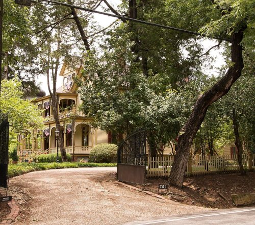
  4. 1895BuiltE. M. Hines House is built
  5. 1895Born hereMorris Kirksey is born here
  6. 20th century
  7. 1908In the archivePostcardAerialViewLookingNorthWaxahachieTXCirca1908
  8. 1912Born hereByron Nelson is born here
  9. 1913In the archiveTwo families working together on Kimball farm, near Waxahachie. The four year old picks n…
  10. 1929Post officeThe Sterrett post office closes
  11. 1936Born hereFrederic Forrest is born here
  12. 1961On the mapFirst mapped by the U.S. Geological Survey
  13. 1977Born hereDesmond Mason is born here
By decade

Waxahachie, decade by decade

2 decades in the archive, from the 1900s to the 1910s. Scroll each row; tap a photo for its story.

1920s–1990snothing yet
Nothing in the archives for these yearsWeddings on Main Street, storms, parades, school pictures, the old store. If it’s in your family album, it belongs here.
Add from your album
On the map

Waxahachie on the map, 1961 to 1978

Every edition of the U.S. Geological Survey’s map of Waxahachie. Tap a year, or press play to watch the town change.

Waxahachie on the 1961 USGS mapWaxahachie on the 1978 USGS map1961Waxahachie sheet · 1:24,000

U.S. Geological Survey historical topographic maps (public domain), via Esri’s collection of the scans. The red ring marks the center of Waxahachie.

Every building

Waxahachie, building by building, 1885–1914

Fire insurance maps drew every building, what it was made of and what it was used for, so insurers could price the risk of fire. Pick a year, then a sheet.

Waxahachie fire insurance map, 1885, sheet 11885Sheet 1 of 2
Edition
BrickWoodStone

Sanborn Map Company, via the Library of Congress. Editions published in 1930 or earlier, which are in the public domain.

Then & now

Stand where they stood

No then-and-now pairs yet. Take a photo from the same spot as an old one and they appear here side by side.

PostcardAerialViewLookingNorthWaxahachieTXCirca1908
Retake this viewPostcardAerialViewLookingNorthWaxahachieTXCirca1908, c. 1908

Find the spot, match the angle, and add your photo. It becomes the first then-and-now pair on Waxahachie’s page.

Retake this view · +15
People over time

Waxahachie, census by census

05,00010,00015,00020,00025,00030,00035,00040,00045,0001880190019201940196019802000202041,140

Grew from 1,354 people in 1880 to 41,140 in 2020, more than tenfold.

15 censuses, 1880–2020.

U.S. Census Bureau decennial counts, from the census table on Waxahachie’s Wikipedia page.

Famous people

19 famous people were born in Waxahachie

Writers, athletes, leaders and more, ranked by how widely they’re known.

See all →
Places that used to be

Lost post offices, old corners and places now gone

Waxahachie’s post office has been open since 1850. Another post office, Sterrett, opened and closed inside today’s town.

Waxahachie
1850–today
Sterrett
1890–1929
18501940today
Hamlets and corners on the map
Sterrett
Gone or out of use
Zook Airfieldairport

US Post Offices dataset (Blevins & Helbock, CC0). Places and cemeteries from the USGS Geographic Names Information System (2021).

Stories next door

History across the town line

Each neighbor’s History grade, on the same three inputs.

Questions about Waxahachie’s history

What year was Waxahachie founded?

The Waxahachie post office opened in 1850, the earliest record of the town by name (U.S. post office records).

How does Waxahachie rank for history?

Waxahachie is more historic than 61% of U.S. towns, #93 of 642 in Texas. The History grade combines the town’s founding era, the share of homes built before 1940 and its National Register listings. It’s a character grade, so it isn’t part of the overall grade. How it works.

What is on the National Register in Waxahachie?

75 listings: 68 buildings, among them the Waxahachie Chautauqua Building (listed 1974, the first), and 7 historic districts with 306 contributing buildings. 382 historic buildings in all.

How old are the homes in Waxahachie?

7% of Waxahachie’s homes were built before 1940 (Census estimate, ±1.5 points), against a typical 1.6% for a Texas town; the median home was built in 2004.

Memory lane

What the archives can’t tell you, neighbors can.

Town Square →
Start a conversation
Sources

Where this page comes from

Founding dates: Wikidata, Wikipedia, the U.S. post office records of Blevins & Helbock (CC0) and the Census. Homes by year built: Census ACS 2020–24. National Register of Historic Places: National Park Service (list of May 22, 2026). Old photos, postcards and papers: Wikimedia Commons, the Library of Congress and other public archives, credited on each item’s page. Maps: U.S. Geological Survey historical topographic maps (via Esri) and Sanborn fire-insurance maps (Library of Congress). History text and census tables: Wikipedia (CC BY-SA 4.0). Places that used to be: USGS Geographic Names Information System (2021).

From Wikimedia Commons (2), the Library of Congress (2), Wikidata (2), the National Register of Historic Places (75), Wikipedia, Wikidata and Wikipedia for famous people, U.S. Geological Survey historical maps, U.S. Census counts (via Wikipedia), the US Post Offices dataset (Blevins & Helbock), the USGS Geographic Names Information System and Sanborn fire insurance maps (Library of Congress). Archive images are copied here with their credits and licenses, shown on each photo’s page. Refreshed monthly.