Guest, Sign inJoin

Post to San Angelo

We’ll email a one-tap link to publish your post. No password, and nothing is public until you click it.
Already a member? Sign in
BHistory
History · San Angelo

69 of San Angelo’s places are on the National Register

More historic than 64% of U.S. towns · #79 of 642 in Texas. What drives it

Most of San Angelo was built recently: 4% of its homes predate 1940 and the median home dates from 1978. Below: maps from 1885 on and the census since 1890.

69on the National Register
4%homes built before 1940
33famous people
Quick answers

About San Angelo’s history

How historic is San Angelo?

B

More historic than 64% of U.S. towns, on its age, its old homes and the National Register.

What drives the grade ↓
History grade

What drives San Angelo’s History grade

On its age, its old homes and the National Register, San Angelo is more historic than 64% of U.S. towns, #79 of 642 in Texas. Its National Register listings hold the grade up; its share of homes from before 1940 pulls it down.

B
HistoryA character grade: shown, never part of San Angelo’s overall grade.
All U.S. towns we grade (21,289)Ahead of 64%
NewerOlder
Texas towns of 2,500+ (642)Ahead of 88%

Among the 400 U.S. cities of 100,000 or more, San Angelo ranks #196 on History.

Few Texas towns list much on the Register (a typical Texas town has 0.0 per 10,000 residents, the U.S. 2.4), so San Angelo’s 12.5 sits above most of its state (88% of Texas towns have fewer) while its 125 historic buildings outnumber those of 91% of U.S. towns.

How sure. Graded on two of the three inputs, so a change in either one moves the letter more than it would with three. The pre-1940 share (±0.8 points) is firm at this size.

Founding year: our sources. Homes: Census ACS 2020–24. National Register: National Park Service, May 2026 list; each listing counted once (boundary changes and added documentation belong to their listing), and a historic district counts its contributing buildings. How TownRatings grades history →

What stands out about San Angelo’s past

Read from the archive, the National Register and the record. The page puts what stands out first.

★ What stands out · On the National Register

69 historic places in San Angelo

The country’s official list of buildings and places worth saving. One is a National Historic Landmark, the highest tier.

places listed
69
National Historic Landmark
1
Fort Concho Historic District
historic buildings protected
125
each building in a district counts
first listed
1966
Fort Concho Historic District
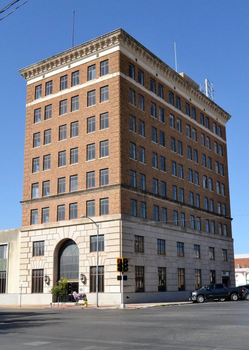
San Angelo National Bank BuildingJ. J. Rackley BuildingHilton HotelAztec Cleaners and Laundry BuildingC. A. Broome HouseClayton HouseCollyns HouseDevelin HouseDr. Herbert A. Wardlaw HouseDr. M. M. Woodward HouseEckert HouseEmmanuel Episcopal ChurchFirst Presbyterian ChurchFisher, O. C., Federal BuildingFrederick Beck FarmGreater St. Paul AME Church, built 1927Hagelstein Commercial BuildingHouse at 1017 South DavidHouse at 1325 South DavidHouse at 140 AllenHouse at 1621 North ChadbourneHouse at 221 North MagdalenHouse at 405 PreusserHouse at 421 West TwohigHouse at 521 West Highland BoulevardHouse at 715 AustinHouse at 731 PreusserHousehold Furniture Co.Iglesia Santa MariaJ. B. Blakeney HouseJ. T. and Minnie McClelland HouseJohn and Anton Willeke HouseJohn Willeke Sr. HouseLone Wolf Crossing BridgeMason-Hughes HouseMasonic Lodge 570Municipal Swimming Pool, built 1938Murrah HouseOakes Hotel BuildingPrincess Ice Cream Co.R. A. Hall HouseR. Wilbur Brown HouseS. L. Henderson HouseSan Angelo City HallSan Angelo Telephone Company BuildingShepperson HouseTom Green County CourthouseWest Texas Utilities OfficeWilliam Schneemann HouseSanta Fe Passenger DepotSanta Fe Railway Freight DepotBuilding at 113-119 East ConchoC. C. Walsh HouseFreeze BuildingHarris Drug StoreRoosevelt HotelTom Green County JailSan Angelo National Bank, Johnson and Taylor, and Schwartz and Raas BuildingsAngelo Heights Historic DistrictHolcomb-Blanton Print ShopHouse at 123 AllenHouse at 419 West Avenue CJohn C. Westbrook HouseJohn Willeke Jr. HouseMonogram SquareMontgomery Ward Building, built 1927Texas Highway Department Building, Warehouse and Motor Vehicle DivisionHouse at 427 West TwohigFort Concho Historic District★
BuildingsDistrictsStructures★ landmark

Architectural styles listings

Vernacular13
Classical Revival12
Colonial Revival9
Prairie6
Eclectic4
Mission Revival4
All 69 listings
Develin HouseBuilding · listed 1988Dr. Herbert A. Wardlaw HouseBuilding · listed 1988Dr. M. M. Woodward HouseBuilding · listed 1988Eckert HouseBuilding · listed 1988Emmanuel Episcopal ChurchBuilding · listed 1988First Presbyterian ChurchBuilding · listed 1988Fisher, O. C., Federal BuildingBuilding · listed 1988Frederick Beck FarmBuilding · listed 1988Greater St. Paul AME ChurchBuilding · listed 1988Hagelstein Commercial BuildingBuilding · listed 1988House at 1017 South DavidBuilding · listed 1988House at 1325 South DavidBuilding · listed 1988House at 140 AllenBuilding · listed 1988House at 1621 North ChadbourneBuilding · listed 1988House at 221 North MagdalenBuilding · listed 1988House at 405 PreusserBuilding · listed 1988House at 421 West TwohigBuilding · listed 1988House at 521 West Highland BoulevardBuilding · listed 1988House at 715 AustinBuilding · listed 1988House at 731 PreusserBuilding · listed 1988Household Furniture Co.Building · listed 1988Iglesia Santa MariaBuilding · listed 1988J. B. Blakeney HouseBuilding · listed 1988J. T. and Minnie McClelland HouseBuilding · listed 1988John and Anton Willeke HouseBuilding · listed 1988John Willeke Sr. HouseBuilding · listed 1988Lone Wolf Crossing BridgeStructure · listed 1988Mason-Hughes HouseBuilding · listed 1988Masonic Lodge 570Building · listed 1988Municipal Swimming PoolBuilding · listed 1988Murrah HouseBuilding · listed 1988Oakes Hotel BuildingBuilding · listed 1988Princess Ice Cream Co.Building · listed 1988R. A. Hall HouseBuilding · listed 1988R. Wilbur Brown HouseBuilding · listed 1988S. L. Henderson HouseBuilding · listed 1988San Angelo City HallBuilding · listed 1988San Angelo Telephone Company BuildingBuilding · listed 1988Shepperson HouseBuilding · listed 1988Tom Green County CourthouseBuilding · listed 1988West Texas Utilities OfficeBuilding · listed 1988William Schneemann HouseBuilding · listed 1988Santa Fe Passenger DepotBuilding · listed 1989Santa Fe Railway Freight DepotBuilding · listed 1989Building at 113-119 East ConchoBuilding · listed 1990C. C. Walsh HouseBuilding · listed 1990Freeze BuildingBuilding · listed 1997Harris Drug StoreBuilding · listed 2001Roosevelt HotelBuilding · listed 2018Tom Green County JailBuilding · listed 1976San Angelo National Bank, Johnson and Taylor, and Schwartz and Raas BuildingsBuilding · listed 1978Angelo Heights Historic DistrictDistrict · listed 1988Holcomb-Blanton Print ShopBuilding · listed 1988House at 123 AllenBuilding · listed 1988House at 419 West Avenue CBuilding · listed 1988John C. Westbrook HouseBuilding · listed 1988John Willeke Jr. HouseBuilding · listed 1988Monogram SquareBuilding · listed 1988Montgomery Ward BuildingBuilding · listed 1988Texas Highway Department Building, Warehouse and Motor Vehicle DivisionBuilding · listed 1988House at 427 West TwohigBuilding · listed 1990

National Park Service, National Register of Historic Places. Photos from Wikimedia Commons, credited on each place’s page.

Help out

Start San Angelo’s collection

The first neighbors to add old photos shape how San Angelo’s history is told.

Decades since 1900 with photos
00s10s20s30s40s50s60s70s80s90s
0 of 10 decades. The empty ones are waiting for someone’s album.
Every building

San Angelo, building by building, 1885–1927

Fire insurance maps drew every building, what it was made of and what it was used for, so insurers could price the risk of fire. Pick a year, then a sheet.

San Angelo fire insurance map, 1885, sheet 11885Sheet 1 of 3
Edition
BrickWoodStone

Sanborn Map Company, via the Library of Congress. Editions published in 1930 or earlier, which are in the public domain.

The story

How San Angelo came to be

From Wikipedia’s history of San Angelo.

Read it all →

In 1632, a short-lived mission of Franciscans under Spanish auspices was founded in the area to serve native people. The mission was led by the friars Juan de Salas and Juan de Ortega, with Ortega remaining for six months. The area was visited by the Castillo-Martin expedition of 1650 and the Diego de Guadalajara expedition of 1654.

During the region's development, San Angelo was at the western edge of the area called Texas, successively claimed in the 1800s by Spain, Mexico, the Republic of Texas, and finally the United States in 1846.

Text from Wikipedia, licensed CC BY-SA 4.0.

Timeline

San Angelo, 1868 to 1966

Woven from the archive, old maps, post office records, the National Register and the people born here.

  1. 19th century
  2. 1868Post officeThe Fort Concho post office opens
  3. 1881Post officeThe San Angela post office opens
  4. 1884Post officeThe Fort Concho post office closes
  5. 20th century
  6. 1927BuiltGreater St. Paul AME Church is built
  7. 1927BuiltMontgomery Ward Building is built
  8. 1928On the mapFirst mapped by the U.S. Geological Survey
  9. 1938BuiltMunicipal Swimming Pool is built
  10. 1942Born hereNancy Richey is born here
  11. 1946Born hereCliff Richey is born here
  12. 1955Born hereMax Lucado is born here
  13. 1961LandmarkFort Concho Historic District named a National Historic Landmark
  14. 1966Born hereGreg Maddux is born here
By decade

San Angelo, decade by decade

On the map

San Angelo on the map, 1928 to 1971

Every edition of the U.S. Geological Survey’s map of San Angelo. Tap a year, or press play to watch the town change.

San Angelo on the 1928 USGS mapSan Angelo on the 1957 USGS mapSan Angelo on the 1971 USGS map1928Wall sheet · 1:62,500

U.S. Geological Survey historical topographic maps (public domain), via Esri’s collection of the scans. The red ring marks the center of San Angelo.

People over time

San Angelo, census by census

020,00040,00060,00080,000100,000190019201940196019802000202099,893

Grew from 2,615 people in 1890 to 99,893 in 2020, more than tenfold.

13 censuses, 1890–2020.

U.S. Census Bureau decennial counts, from the census table on San Angelo’s Wikipedia page.

Famous people

33 famous people were born in San Angelo

Writers, athletes, leaders and more, ranked by how widely they’re known.

See all →
Places that used to be

Lost post offices, old corners, places now gone and burying grounds

Another post office, Fort Concho, opened and closed inside today’s town.

Fort Concho
1868–1884
San Angela
1881–today
18601940today
Hamlets and corners on the map
Alvery JunctionS N Junction
Gone or out of use
Lamar SchoolschoolLindell Avenue ChurchchurchSan Angelo Army Air Fieldmilitary
4cemeteries and burying grounds inside San Angelo
Belvedere MemorialCalvaryDelta MemorialFairmount

US Post Offices dataset (Blevins & Helbock, CC0). Places and cemeteries from the USGS Geographic Names Information System (2021).

Questions about San Angelo’s history

How does San Angelo rank for history?

San Angelo is more historic than 64% of U.S. towns, #79 of 642 in Texas. The History grade combines the town’s founding era, the share of homes built before 1940 and its National Register listings. It’s a character grade, so it isn’t part of the overall grade. How it works.

What is on the National Register in San Angelo?

69 listings: 66 buildings, 2 historic districts, the Fort Concho Historic District and the Angelo Heights Historic District, with 54 contributing buildings, and 1 structure. 125 historic buildings in all.

How old are the homes in San Angelo?

4% of San Angelo’s homes were built before 1940 (Census estimate), against a typical 1.6% for a Texas town; the median home was built in 1978.

Memory lane

What the archives can’t tell you, neighbors can.

Town Square →
Start a conversation
Sources

Where this page comes from

Founding dates: Wikidata, Wikipedia, the U.S. post office records of Blevins & Helbock (CC0) and the Census. Homes by year built: Census ACS 2020–24. National Register of Historic Places: National Park Service (list of May 22, 2026). Old photos, postcards and papers: Wikimedia Commons, the Library of Congress and other public archives, credited on each item’s page. Maps: U.S. Geological Survey historical topographic maps (via Esri) and Sanborn fire-insurance maps (Library of Congress). History text and census tables: Wikipedia (CC BY-SA 4.0). Places that used to be: USGS Geographic Names Information System (2021).

From Wikimedia Commons (3), Wikidata (2), the National Register of Historic Places (69), Wikipedia, Wikidata and Wikipedia for famous people, U.S. Geological Survey historical maps, U.S. Census counts (via Wikipedia), the US Post Offices dataset (Blevins & Helbock), the USGS Geographic Names Information System and Sanborn fire insurance maps (Library of Congress). Archive images are copied here with their credits and licenses, shown on each photo’s page. Refreshed monthly.