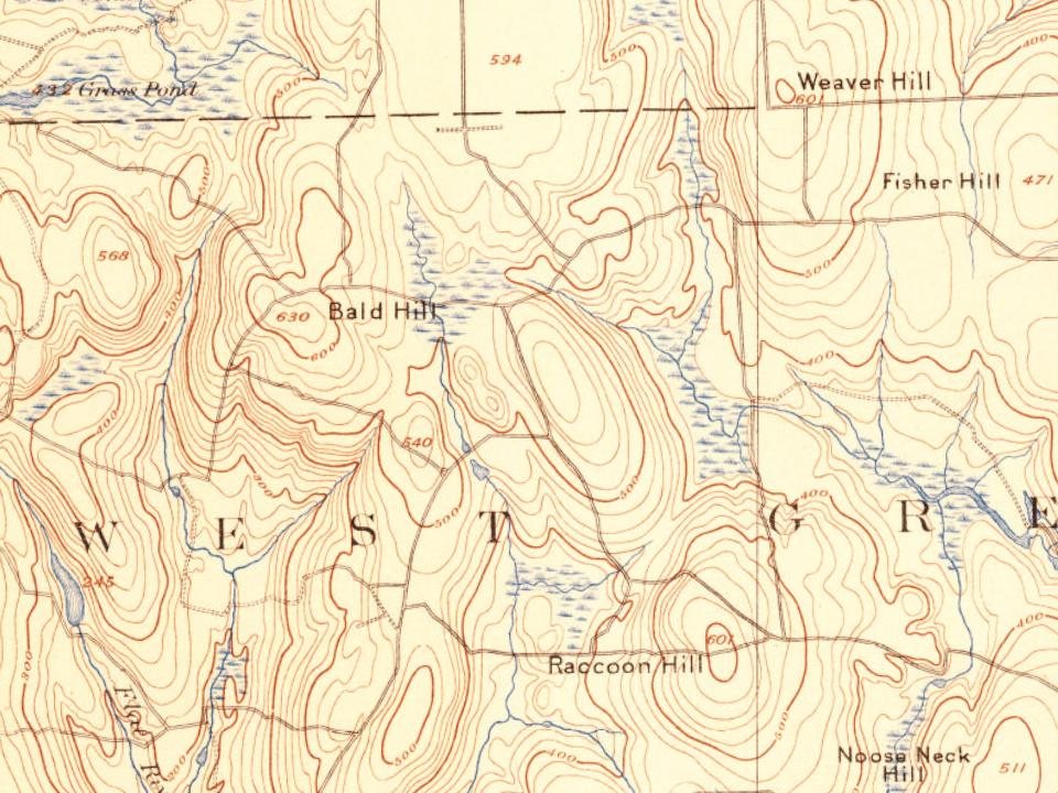
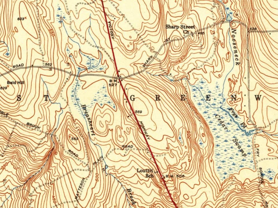
Most of West Greenwich was built recently: 9% of its homes predate 1940 and the median home dates from 1991. Its Register listings are the Stephen Allen House and the West Greenwich Baptist Church and Cemetery. Below: 2 old photos and papers, maps from 1890 on, and the census since 1790.
From West Greenwich’s archive · credits on each photo
Quick answers
How West Greenwich began
When was West Greenwich founded?
1832
The West Greenwich post office opened in 1832, the earliest record of the town by name. Two smaller post offices, Noose Neck Hill (1848) and West Greenwich Centre (1848), opened inside today’s town and later closed.
First census: 2,054 in 17902020 census: 6,528194 years
How historic is West Greenwich?
B−
More historic than 53% of U.S. towns, on its age, its old homes and the National Register.
Founding year: the first West Greenwich post office (Blevins & Helbock, CC0).
History grade
What drives West Greenwich’s History grade
On its age, its old homes and the National Register, West Greenwich is more historic than 53% of U.S. towns. Its age holds the grade up; its National Register listings pull it down.
B−
HistoryA character grade: shown, never part of West Greenwich’s overall grade.
Rhode Island towns list more on the Register than most of the country (a typical Rhode Island town has 94.7 per 10,000 residents, the U.S. 2.4), so West Greenwich’s 6.0 sits below most of its state (0% of Rhode Island towns have fewer) while its 4 historic buildings outnumber those of 68% of U.S. towns.
How sure. Graded on any two of the three inputs instead, the letter would range from C to B. The pre-1940 share is a Census survey estimate (±5.9 points). The founding year is the first post office, not a stated founding date.
Founding year: the first post office (other dates in Quick answers). Homes: Census ACS 2020–24. National Register: National Park Service, May 2026 list; each listing counted once (boundary changes and added documentation belong to their listing), and a historic district counts its contributing buildings. How TownRatings grades history →
What stands out about West Greenwich’s past
Read from the archive, the National Register and the record. The page puts what stands out first.
85family graveyards and cemeteries inside West Greenwich
Abel Greene LotAllen - Tanner LotAllen James LotAmasa Pratt LotAmos Letson LotAndrew Edward LotArnold - Harrington LotAsel Bates LotAustin - Hopkins LotBenjamin Greene LotBeriah Hopkins LotCaleb Bailey LotCaptain John Fry LotCaptain John Tillinghast LotCasey - Rathbun LotChristopher Carpenter LotClark Franklin LotClark Lewis LotClemens LotDaniel Ladd LotDavid Hall LotDavid Johnson LotDavid Matteson LotEllis LotFrancis Morris LotGeorge Potter LotGideon Ellis LotGreene - Waite LotGreene LotHazard LotHenry Albro LotHistorical Cemetery 134Historical Cemetery 59Hopkins LotIsaac Johnson LotIsrael Newton LotIsreal Gates LotJacob Lewis LotJacob Weaver LotJames Greene LotJob Harrington LotJohn Andrews LotJohn Matteson LotJoseph Hoxie LotJoseph Nichols LotLaban Matteson LotLevi Whitford LotMagdelen King LotMatteson LotMolasses Pardon Tillnghast LotNathaniel Brown LotNicholas Brown LotNiles Nichols Congdon LotOliver Matteson LotOliver Matteson LotPardon Brown LotPhilip Matteson LotPlain Meeting HousePreserved Hall LotRandall Capwell LotReynolds Sweet LotSaint Joseph'sSeth Brown LotSilas James LotSilas Matteson LotSimeon Whitford LotSpencer Bentley LotStafford Greene LotStone - Wilcox LotStrait - Wood LotStuckeley Matteson LotSweet Burial GroundTarbox - Jackson LotTheophilus Whale LotThomas Hall LotThomas Matteson LotThomas Matteson LotThomas Morris LotThomas Spink LotThomas Tillinghast LotTillinghast Slave LotWaite - Tillinghast LotWaite Ellis LotWarner LotWilliam J Potter Lot
See all 85
Abel Greene Lot Cemetery · Allen - Tanner Lot Cemetery · Allen James Lot Cemetery · Amasa Pratt Lot Cemetery · Amos Letson Lot Cemetery · Andrew Edward Lot · Arnold - Harrington Lot Cemetery · Asel Bates Lot Cemetery · Austin - Hopkins Lot Cemetery · Benjamin Greene Lot Cemetery · Beriah Hopkins Lot Cemetery · Caleb Bailey Lot Cemetery · Captain John Fry Lot Cemetery · Captain John Tillinghast Lot Cemetery · Casey - Rathbun Lot Cemetery · Christopher Carpenter Lot Cemetery · Clark Franklin Lot Cemetery · Clark Lewis Lot Cemetery · Clemens Lot · Daniel Ladd Lot Cemetery · David Hall Lot Cemetery · David Johnson Lot · David Matteson Lot Cemetery · Ellis Lot Cemetery · Francis Morris Lot Cemetery · George Potter Lot Cemetery · Gideon Ellis Lot Cemetery · Greene - Waite Lot Cemetery · Greene Lot Cemetery · Hazard Lot Cemetery · Henry Albro Lot Cemetery · Historical Cemetery 134 · Historical Cemetery 59 · Hopkins Lot Cemetery · Isaac Johnson Lot · Israel Newton Lot Cemetery · Isreal Gates Lot Cemetery · Jacob Lewis Lot Cemetery · Jacob Weaver Lot Cemetery · James Greene Lot Cemetery · Job Harrington Lot Cemetery · John Andrews Lot Cemetery · John Matteson Lot Cemetery · Joseph Hoxie Lot · Joseph Nichols Lot · Laban Matteson Lot Cemetery · Levi Whitford Lot Cemetery · Magdelen King Lot Cemetery · Matteson Lot Cemetery · Molasses Pardon Tillnghast Lot Cemetery · Nathaniel Brown Lot Cemetery · Nicholas Brown Lot · Niles Nichols Congdon Lot Cemetery · Oliver Matteson Lot Cemetery · Oliver Matteson Lot Cemetery · Pardon Brown Lot Cemetery · Philip Matteson Lot Cemetery · Plain Meeting House Cemetery · Preserved Hall Lot Cemetery · Randall Capwell Lot Cemetery · Reynolds Sweet Lot Cemetery · Saint Joseph's Cemetery · Seth Brown Lot Cemetery · Silas James Lot Cemetery · Silas Matteson Lot Cemetery · Simeon Whitford Lot Cemetery · Spencer Bentley Lot · Stafford Greene Lot Cemetery · Stone - Wilcox Lot Cemetery · Strait - Wood Lot Cemetery · Stuckeley Matteson Lot Cemetery · Sweet Burial Ground Cemetery · Tarbox - Jackson Lot Cemetery · Theophilus Whale Lot Cemetery · Thomas Hall Lot Cemetery · Thomas Matteson Lot · Thomas Matteson Lot Cemetery · Thomas Morris Lot Cemetery · Thomas Spink Lot · Thomas Tillinghast Lot Cemetery · Tillinghast Slave Lot · Waite - Tillinghast Lot Cemetery · Waite Ellis Lot Cemetery · Warner Lot Cemetery · William J Potter Lot Cemetery
US Post Offices dataset (Blevins & Helbock, CC0). Places and cemeteries from the USGS Geographic Names Information System (2021).
Help out
Start West Greenwich’s collection
The first neighbors to add old photos shape how West Greenwich’s history is told.
Decades since 1900 with photos
00s10s20s30s40s50s60s70s80s90s
1 of 10 decades. The empty ones are waiting for someone’s album.
Lost two-thirds of its people between 1790 and 1920, then grew more than tenfold.
24 censuses, 1790–2020.
U.S. Census Bureau decennial counts, from the census table on West Greenwich’s Wikipedia page.
The story so far
West Greenwich, in brief
Wikipedia doesn’t have a history of West Greenwich yet. The photos, dates and memories neighbors add here are how it gets written.
West Greenwich is a town in Kent County, Rhode Island, United States. The population was 6,528 at the 2020 census. West Greenwich was named for the historic town of Greenwich, Kent, England. It was separated from East Greenwich in 1741. Students go to Exeter-West Greenwich Regional School District in West Greenwich.
Its first post office opened in 1832. Between the 2010 and 2020 censuses its population grew from 6,135 to 6,528 (+6%).
Intro from Wikipedia. Population: U.S. Census Bureau.
Timeline
West Greenwich, 1805 to 2020
Woven from the archive, old maps, post office records, the National Register and the people born here.
Nothing in the archives for these yearsWeddings on Main Street, storms, parades, school pictures, the old store. If it’s in your family album, it belongs here.
Every edition of the U.S. Geological Survey’s map of West Greenwich. Tap a year, or press play to watch the town change.
1890Kent sheet · 1:62,500
U.S. Geological Survey historical topographic maps (public domain), via Esri’s collection of the scans. The red ring marks the center of West Greenwich.
Then & now
Stand where they stood
No then-and-now pairs yet. Take a photo from the same spot as an old one and they appear here side by side.
Retake this viewFARM IN WEST GREENWICH. STONE OUTCROPPINGS TYPIFY NEW ENGLAND SOIL, 1973
Find the spot, match the angle, and add your photo. It becomes the first then-and-now pair on West Greenwich’s page.
The West Greenwich post office opened in 1832, the earliest record of the town by name (U.S. post office records).
How does West Greenwich rank for history?
West Greenwich is more historic than 53% of U.S. towns. The History grade combines the town’s founding era, the share of homes built before 1940 and its National Register listings. It’s a character grade, so it isn’t part of the overall grade. How it works.
What is on the National Register in West Greenwich?
Two places: the Stephen Allen House (listed 1978) and the West Greenwich Baptist Church and Cemetery (1978).
How old are the homes in West Greenwich?
9% of West Greenwich’s homes were built before 1940 (Census estimate, ±5.9 points), against a typical 20% for a Rhode Island town; the median home was built in 1991.
Founding dates: Wikidata, Wikipedia, the U.S. post office records of Blevins & Helbock (CC0) and the Census. Homes by year built: Census ACS 2020–24. National Register of Historic Places: National Park Service (list of May 22, 2026). Old photos, postcards and papers: Wikimedia Commons, the Library of Congress and other public archives, credited on each item’s page. Maps: U.S. Geological Survey historical topographic maps (via Esri) and Sanborn fire-insurance maps (Library of Congress). History text and census tables: Wikipedia (CC BY-SA 4.0). Places that used to be: USGS Geographic Names Information System (2021).
From Wikimedia Commons (12), the National Register of Historic Places (2), Wikidata and Wikipedia for famous people, U.S. Geological Survey historical maps, U.S. Census counts (via Wikipedia), the US Post Offices dataset (Blevins & Helbock) and the USGS Geographic Names Information System. Archive images are copied here with their credits and licenses, shown on each photo’s page. Refreshed monthly.



 1973
 2014
 2013
 2013
 2013
 2013
 2013
 2013
 2012
 2012
 2010