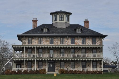
Little Compton dates to 1659, and 21% of its homes were built before 1940
More historic than 90% of U.S. towns · #16 of 38 in Rhode Island. What drives it
7 places in town are on the National Register, among them a historic district with 24 buildings. Below: 12 old photos and papers, maps from 1888 on, and the census since 1790.
Founding year: Wikidata. First post office: 1804.The full story ↓
History grade
What drives Little Compton’s History grade
On its age, its old homes and the National Register, Little Compton is more historic than 90% of U.S. towns, #16 of 38 in Rhode Island. All 3 inputs are above most U.S. towns; its age ranks highest and its National Register listings lowest.
A
HistoryA character grade: shown, never part of Little Compton’s overall grade.
Rhode Island towns list more on the Register than most of the country (a typical Rhode Island town has 94.7 per 10,000 residents, the U.S. 2.4), so Little Compton’s 97.7 sits near the middle of its state (50% of Rhode Island towns have fewer) while its 35 historic buildings outnumber those of 83% of U.S. towns.
NoteThe founding year comes from Wikidata alone; no second source gives 1659.
How sure. Graded on any two of the three inputs instead, the letter would range from A− to A. The pre-1940 share is a Census survey estimate (±7.0 points).
Founding year: Wikidata (other dates in Quick answers). Homes: Census ACS 2020–24. National Register: National Park Service, May 2026 list; each listing counted once (boundary changes and added documentation belong to their listing), and a historic district counts its contributing buildings. How TownRatings grades history →
What stands out about Little Compton’s past
Read from the archive, the National Register and the record. The page puts what stands out first.
Every edition of the U.S. Geological Survey’s map of Little Compton. Tap a year, or press play to watch the town change.
1888Fall River sheet · 1:62,500
U.S. Geological Survey historical topographic maps (public domain), via Esri’s collection of the scans. The red ring marks the center of Little Compton.
Places that used to be
Lost post offices, old corners, places now gone and burying grounds
Little Compton’s post office has been open since 1804. Two other post offices opened and closed inside today’s town.
Little Compton
1804–today
Commons
1830–1847
Adamsville
1847–today
Sakonnet
1904–1924
18001910today
Hamlets and corners on the map
AdamsvilleBahia CornerPottersvilleSakonnet
Gone or out of use
Grays StorelocaleStone Schoolschool
39family graveyards and cemeteries inside Little Compton
Abial Tripp LotAdamsville ChurchAlmyBenjamin Head LotBriggs Brownell LotCaptain Edward Richmond LotCaptain Sylvester Woodman LotGeorge Brownell LotGifford Lot SouthHoxsey - Taber - ManchesterIrish LotJohn Woodman LotJoseph Brownell LotJoseph Gifford LotJoseph WilborLemuel Brightman LotLittle Compton Historical Cemetery 43ManleyOld Commons Burial GroundOld WilborOur Lady of Fatima CatholicPerry SimmonsQuaker Meeting HouseSamuel Church LotSeaconnetShaw and Seabury LotSimmons HillSowle LotStephen Simmons LotStoddard LotThomas Brownell LotThomas Wilbor LotUnionWhite Family Burying GroundWilbor - Gifford LotWilbor - Tripp LotWilliam Briggs LotWilliam WilborWright Pearce Lot
See all 39
Abial Tripp Lot Cemetery · Adamsville Church Cemetery · Almy Cemetery · Benjamin Head Lot Cemetery · Briggs Brownell Lot Cemetery · Captain Edward Richmond Lot Cemetery · Captain Sylvester Woodman Lot Cemetery · George Brownell Lot Cemetery · Gifford Lot South · Hoxsey - Taber - Manchester Cemetery · Irish Lot Cemetery · John Woodman Lot Cemetery · Joseph Brownell Lot Cemetery · Joseph Gifford Lot Cemetery · Joseph Wilbor Cemetery · Lemuel Brightman Lot Cemetery · Little Compton Historical Cemetery 43 · Manley Cemetery · Old Commons Burial Ground Cemetery · Old Wilbor Cemetery · Our Lady of Fatima Catholic Cemetery · Perry Simmons Cemetery · Quaker Meeting House Burial Ground · Samuel Church Lot · Seaconnet Cemetery · Shaw and Seabury Lot Cemetery · Simmons Hill Burying Ground · Sowle Lot Cemetery · Stephen Simmons Lot Cemetery · Stoddard Lot Cemetery · Thomas Brownell Lot Cemetery · Thomas Wilbor Lot Cemetery · Union Cemetery · White Family Burying Ground Cemetery · Wilbor - Gifford Lot Cemetery · Wilbor - Tripp Lot Cemetery · William Briggs Lot Cemetery · William Wilbor Cemetery · Wright Pearce Lot Cemetery
US Post Offices dataset (Blevins & Helbock, CC0). Places and cemeteries from the USGS Geographic Names Information System (2021).
Little Compton was originally inhabited by the Sakonnet Indians and their settlement was called Sakonnet or Saughonet. The name has been interpreted in a variety of ways including "where the water pours forth".
Passages that mention Little Compton, cut from the printed page as they were published.
History of Newport County, Rhode Island. From the year 1638 to the year 1887, including the settlement of its towns, and their subsequent progress1888 · page 1010Read the page →
Read the text
structure of 1723-24 was built by a subscription of C'olO Os. 7d., and from that time the contributors or their principals took the name of the " Proprietors of the Congregational Meeting House of Little Compton." The proprietors originally intended this meeting house for the use of the Congregational church, and in 1746 passed a formal resolution, drawn by the pastor, in which they " forever devote .... the meeting house for the public worship of God, to the Church and Christian so-
Text read by machine from the scan; it may contain errors.
History of Newport County, Rhode Island. From the year 1638 to the year 1887, including the settlement of its towns, and their subsequent progress1888 · page 974Read the page →
Read the text
The general historical interest in Little Compton as the scene of stirring events, fraught with far reaching consequences, centers in the four score years which preceded its incorporation as a town of Newport county. In the history of Tiverton the peculiar relations which, during that period, were sustained alike by Tiverton and Little Ci)mptou to the pai-ent colonies were noticed, and those troublesome controversies regarding the eastern boundary of these two towns having been fully dis-
Text read by machine from the scan; it may contain errors.
Scans and text from the Internet Archive. Books published in 1930 or earlier, which are in the public domain.
By decade
Little Compton, decade by decade
3 decades in the archive, from the 1900s to the 1940s. Scroll each row; tap a photo for its story.
Nothing in the archives for these yearsWeddings on Main Street, storms, parades, school pictures, the old store. If it’s in your family album, it belongs here.
In 1659, according to Wikidata. Little Compton’s post office opened in 1804, and the first U.S. census counted 1,542 people here in 1790.
How does Little Compton rank for history?
Little Compton is more historic than 90% of U.S. towns, #16 of 38 in Rhode Island. The History grade combines the town’s founding era, the share of homes built before 1940 and its National Register listings. It’s a character grade, so it isn’t part of the overall grade. How it works.
What is on the National Register in Little Compton?
7 listings: 5 buildings, 1 historic district, the Little Compton Common Historic District, with 24 contributing buildings, and 1 object. 35 historic buildings in all.
How old are the homes in Little Compton?
21% of Little Compton’s homes were built before 1940 (Census estimate, ±7.0 points), against a typical 20% for a Rhode Island town; the median home was built in 1969.
Founding dates: Wikidata, Wikipedia, the U.S. post office records of Blevins & Helbock (CC0) and the Census. Homes by year built: Census ACS 2020–24. National Register of Historic Places: National Park Service (list of May 22, 2026). Old photos, postcards and papers: Wikimedia Commons, the Library of Congress and other public archives, credited on each item’s page. Maps: U.S. Geological Survey historical topographic maps (via Esri) and Sanborn fire-insurance maps (Library of Congress). History text and census tables: Wikipedia (CC BY-SA 4.0). Places that used to be: USGS Geographic Names Information System (2021).
From Wikimedia Commons (1), the Library of Congress (11), the National Register of Historic Places (7), Wikipedia, Wikidata and Wikipedia for famous people, U.S. Geological Survey historical maps, U.S. Census counts (via Wikipedia), the US Post Offices dataset (Blevins & Helbock), the USGS Geographic Names Information System and old county and town histories (Internet Archive). Archive images are copied here with their credits and licenses, shown on each photo’s page. Refreshed monthly.


 1940
 1940
 1940
 1940
 1940
 1940
 1940
 1940
 1940