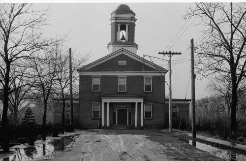
Wyoming’s post office opened in 1839, and 30% of its homes were built before 1940
More historic than 90% of U.S. towns · #186 of 1,035 in Pennsylvania. What drives it
Its Register listings are the Swetland Homestead, the Luzerne Presbyterial Institute and the Wyoming Monument. Below: 11 old photos and papers, maps from 1893 on, and the census since 1880.
On its age, its old homes and the National Register, Wyoming is more historic than 90% of U.S. towns, #186 of 1,035 in Pennsylvania. All 3 inputs are above most U.S. towns; its share of homes from before 1940 ranks highest and its National Register listings lowest.
A
HistoryA character grade: shown, never part of Wyoming’s overall grade.
Pennsylvania towns list about as much on the Register as the country (a typical Pennsylvania town has 2.1 per 10,000 residents, the U.S. 2.4), so Wyoming’s 9.6 sits above most of its state (77% of Pennsylvania towns have fewer) while its 3 listings outnumber those of 65% of U.S. towns.
How sure. Graded on any two of the three inputs instead, the letter would range from A− to A. The pre-1940 share is a Census survey estimate (±7.6 points). The founding year is the first post office, not a stated founding date; Wikidata gives 1885.
Founding year: the first post office (other dates in Quick answers). Homes: Census ACS 2020–24. National Register: National Park Service, May 2026 list; each listing counted once (boundary changes and added documentation belong to their listing), and a historic district counts its contributing buildings. How TownRatings grades history →
What stands out about Wyoming’s past
Read from the archive, the National Register and the record. The page puts what stands out first.
Every edition of the U.S. Geological Survey’s map of Wyoming. Tap a year, or press play to watch the town change.
1893Pittston sheet · 1:62,500
U.S. Geological Survey historical topographic maps (public domain), via Esri’s collection of the scans. The red ring marks the center of Wyoming.
People over time
Wyoming, census by census
Peaked at 4,728 in 1940; 3,102 people lived here in 2020.
15 censuses, 1880–2020.
U.S. Census Bureau decennial counts, from the census table on Wyoming’s Wikipedia page.
Every building
Wyoming, building by building, 1897–1911
Fire insurance maps drew every building, what it was made of and what it was used for, so insurers could price the risk of fire. Pick a year, then a sheet.
1897Sheet 1 of 1
Edition
Sheets
BrickWoodStone
Sanborn Map Company, via the Library of Congress. Editions published in 1930 or earlier, which are in the public domain.
By the 1700s, the Wyoming Valley was inhabited by several Native American tribes (including the Susquehannock and the Delaware). In the mid-18th century, Connecticut settlers ventured into the valley. These were the first recorded Europeans in the region. In 1768, the Susquehanna Company of Connecticut devised a plan to divide the Wyoming Valley into five townships. Each township was to be divided amongst forty settlers. Wyoming was originally part of Kingston Township.
Passages that mention Wyoming, cut from the printed page as they were published.
The Historical record of Wyoming Valley1901 · page 203Read the page →
Read the text
vs. Luzerne County, 197 Pa., 3, has well summarized the origin of our present parks. "Under the Connecticut settlement of the Wyoming Valley, the township of Wilkes-Barre was first surveyed and laid out by David Meade in 1770. In 1773 the town plot of what afterwards became the borough of
Text read by machine from the scan; it may contain errors.
Genealogical and family history of the Wyoming and Lackawanna valleys, Pennsylvania1906 · page 49Read the page →
Read the text
of 1769), a large body of settlers from Connecticut and other colonies had been sent by the Susquehanna Company to take possession of the Wyoming region on the East Branch of the Susquehanna river. Zebulon Butler was an inconspicuous member of that body, but within a short time he became prominent in the affairs not only of the little Wyoming settlement, but of the Sus-
Text read by machine from the scan; it may contain errors.
Genealogical and family history of the Wyoming and Lackawanna valleys, Pennsylvania1906 · page 38Read the page →
Read the text
Henderson Gaylord, Hon. George W. Woodward, William Swetland, Samuel Hoyt and others whose interests lay mainly in the development of the mineral resources of Wyoming Valley, secured the charter for, and in 1854 proceeded to build the Lackawanna and Bloomsburg Railroad, extending from Scranton to Rupert, Pennsylvania, first, and then to Northumberland, and
Text read by machine from the scan; it may contain errors.
The Historical record of Wyoming Valley1901 · page 163Read the page →
Read the text
The township of Wllkes-Barre, one of the original seventeen townships laid out by the Connecticut settlers in Wyoming Valley, was surveyed In 1769 by Col. John Durkee, and was named in honor of Col. John Wilkes and Ool.
Text read by machine from the scan; it may contain errors.
Scans and text from the Internet Archive. Books published in 1930 or earlier, which are in the public domain.
Timeline
Wyoming, 1778 to 1984
Woven from the archive, old maps, post office records, the National Register and the people born here.
Nothing in the archives for these yearsWeddings on Main Street, storms, parades, school pictures, the old store. If it’s in your family album, it belongs here.
Nothing in the archives for these yearsWeddings on Main Street, storms, parades, school pictures, the old store. If it’s in your family album, it belongs here.
The Wyoming post office opened in 1839, the earliest record of the town by name (U.S. post office records). Wikidata gives 1885.
How does Wyoming rank for history?
Wyoming is more historic than 90% of U.S. towns, #186 of 1,035 in Pennsylvania. The History grade combines the town’s founding era, the share of homes built before 1940 and its National Register listings. It’s a character grade, so it isn’t part of the overall grade. How it works.
What is on the National Register in Wyoming?
Three places: the Swetland Homestead (listed 1978), the Luzerne Presbyterial Institute (1979) and the Wyoming Monument (2002).
How old are the homes in Wyoming?
30% of Wyoming’s homes were built before 1940 (Census estimate, ±7.6 points), against a typical 18% for a Pennsylvania town; the median home was built in 1950.
Founding dates: Wikidata, Wikipedia, the U.S. post office records of Blevins & Helbock (CC0) and the Census. Homes by year built: Census ACS 2020–24. National Register of Historic Places: National Park Service (list of May 22, 2026). Old photos, postcards and papers: Wikimedia Commons, the Library of Congress and other public archives, credited on each item’s page. Maps: U.S. Geological Survey historical topographic maps (via Esri) and Sanborn fire-insurance maps (Library of Congress). History text and census tables: Wikipedia (CC BY-SA 4.0). Places that used to be: USGS Geographic Names Information System (2021).
From Wikimedia Commons (5), the Library of Congress (6), Wikidata (1), the National Register of Historic Places (3), Wikipedia, U.S. Geological Survey historical maps, U.S. Census counts (via Wikipedia), the US Post Offices dataset (Blevins & Helbock), the USGS Geographic Names Information System, Sanborn fire insurance maps (Library of Congress) and old county and town histories (Internet Archive). Archive images are copied here with their credits and licenses, shown on each photo’s page. Refreshed monthly.


 1860
 1885
 Date?
 Date?
 Date?