Founding year: Wikidata. First post office: 1846.The full story ↓
History grade
What drives Slippery Rock Township’s History grade
On its age, its old homes and the National Register, Slippery Rock Township is more historic than 77% of U.S. towns, #362 of 1,035 in Pennsylvania. All 3 inputs are above most U.S. towns; its age ranks highest and its National Register listings lowest.
A−
HistoryA character grade: shown, never part of Slippery Rock Township’s overall grade.
Pennsylvania towns list about as much on the Register as the country (a typical Pennsylvania town has 2.1 per 10,000 residents, the U.S. 2.4), so Slippery Rock Township’s 3.5 sits near the middle of its state (63% of Pennsylvania towns have fewer) while its 1 listings outnumber those of 51% of U.S. towns.
NoteThe founding year comes from Wikidata alone; no second source gives 1841.
How sure. Graded on any two of the three inputs instead, the letter would range from B+ to A−. The pre-1940 share is a Census survey estimate (±7.1 points).
Founding year: Wikidata (other dates in Quick answers). Homes: Census ACS 2020–24. National Register: National Park Service, May 2026 list; each listing counted once (boundary changes and added documentation belong to their listing), and a historic district counts its contributing buildings. How TownRatings grades history →
What stands out about Slippery Rock Township’s past
Read from the archive, the National Register and the record. The page puts what stands out first.
Lost post offices, old corners and burying grounds
Three other post offices opened and closed inside today’s town.
Princeton
1846–1918
Rose Point
1852–1933
Grant City
1874–1894
18401930today
Hamlets and corners on the map
GibsondaleGrant CityKennedy MillMcConnells MillPrincetonRose Point
5cemeteries and burying grounds inside Slippery Rock Township
Harmony Baptist ChurchHermon - UnionPleasant ValleyRose Point Reformed Presbyterian ChurchSaint Nicholas Orthodox
US Post Offices dataset (Blevins & Helbock, CC0). Places and cemeteries from the USGS Geographic Names Information System (2021).
People over time
Slippery Rock Township, census by census
Peaked at 4,949 in 1970; 3,081 people lived here in 2020.
18 censuses, 1850–2020.
U.S. Census Bureau decennial counts, from the census table on Slippery Rock Township’s Wikipedia page.
On the map
Slippery Rock Township on the map, 1908 to 1990
Every edition of the U.S. Geological Survey’s map of Slippery Rock Township. Tap a year, or press play to watch the town change.
1908Zelienople sheet · 1:62,500
U.S. Geological Survey historical topographic maps (public domain), via Esri’s collection of the scans. The red ring marks the center of Slippery Rock Township.
The story
How Slippery Rock Township came to be
From Wikipedia’s history of Slippery Rock Township.
The origins of the name "Slippery Rock" date back to colonial times, when members of the Seneca Nation chased European soldiers through the area where Slippery Rock lies today. While crossing a creek, the Seneca lost their footing and slipped on the moss-covered rocks of the creek. The Seneca would later name the creek Slippery Rock.
The post office for Slippery Rock Township was established in 1826 in the Ginger Hill area. The town of Ginger Hill was incorporated as a borough under the name Centreville in 1841, later changing its name to Slippery Rock in 1896 after the Slippery Rock Creek.
What they wrote about Slippery Rock Township in 1908
Passages that mention Slippery Rock Township, cut from the printed page as they were published.
20th century history of New Castle and Lawrence County, Pennsylvania1908 · page 919Read the page →
Read the text
Thomas IMyers attended the public schools of Slippery Rock Township and engaged in farming on the home place until 1882. He then went to live with his fatherin-law, John Leslie, who owned a farm in Slippery Rock Township, and continued there one year. He then successively rented the Joseph Monroe farm in Shenango
Text read by machine from the scan; it may contain errors.
20th century history of New Castle and Lawrence County, Pennsylvania1908 · page 883Read the page →
Read the text
Andrew Fox came to Lawrence Coimty from the eastern part of the country, and bought the farm on which his son, James W., was born, in Slippery Rock Township. In his earlier years he operated a grist mill, together with farming, in Slippery Rock Township, but later in life he moved to a farm near Hillsville, where he died
Text read by machine from the scan; it may contain errors.
Scans and text from the Internet Archive. Books published in 1930 or earlier, which are in the public domain.
Timeline
Slippery Rock Township, 1841 to 1970
Woven from the archive, old maps, post office records, the National Register and the people born here.
Nothing in the archives for these yearsWeddings on Main Street, storms, parades, school pictures, the old store. If it’s in your family album, it belongs here.
In 1841, according to Wikidata. Slippery Rock Township’s post office opened in 1846, and the census of 1850 counted 278 people here.
How does Slippery Rock Township rank for history?
Slippery Rock Township is more historic than 77% of U.S. towns, #362 of 1,035 in Pennsylvania. The History grade combines the town’s founding era, the share of homes built before 1940 and its National Register listings. It’s a character grade, so it isn’t part of the overall grade. How it works.
What is on the National Register in Slippery Rock Township?
One place: the McConnell's Mill Covered Bridge (listed 1980).
How old are the homes in Slippery Rock Township?
19% of Slippery Rock Township’s homes were built before 1940 (Census estimate, ±7.1 points), against a typical 18% for a Pennsylvania town; the median home was built in 1976.
Founding dates: Wikidata, Wikipedia, the U.S. post office records of Blevins & Helbock (CC0) and the Census. Homes by year built: Census ACS 2020–24. National Register of Historic Places: National Park Service (list of May 22, 2026). Old photos, postcards and papers: Wikimedia Commons, the Library of Congress and other public archives, credited on each item’s page. Maps: U.S. Geological Survey historical topographic maps (via Esri) and Sanborn fire-insurance maps (Library of Congress). History text and census tables: Wikipedia (CC BY-SA 4.0). Places that used to be: USGS Geographic Names Information System (2021).
From Wikimedia Commons (12), the National Register of Historic Places (1), Wikipedia, U.S. Geological Survey historical maps, U.S. Census counts (via Wikipedia), the US Post Offices dataset (Blevins & Helbock), the USGS Geographic Names Information System and old county and town histories (Internet Archive). Archive images are copied here with their credits and licenses, shown on each photo’s page. Refreshed monthly.


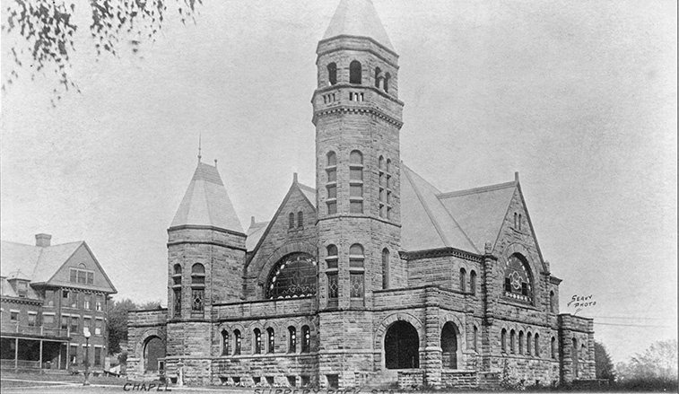


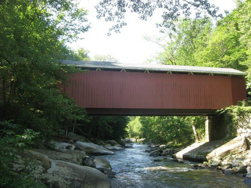


 1893
 1896
 1898
 1898
 1900
 1900
 1900
 1900
 1900
 1900
