Founding year: Wikipedia. First post office: 1825.The full story ↓
History grade
What drives Saville Township’s History grade
On its age, its old homes and the National Register, Saville Township is more historic than 77% of U.S. towns, #367 of 1,035 in Pennsylvania. All 3 inputs are above most U.S. towns; its age ranks highest and its share of homes from before 1940 lowest.
A−
HistoryA character grade: shown, never part of Saville Township’s overall grade.
Pennsylvania towns list about as much on the Register as the country (a typical Pennsylvania town has 2.1 per 10,000 residents, the U.S. 2.4), so Saville Township’s 7.6 sits above most of its state (73% of Pennsylvania towns have fewer) while its 2 listings outnumber those of 60% of U.S. towns.
How sure. Graded on any two of the three inputs instead, the letter would range from B+ to A−. The pre-1940 share is a Census survey estimate (±5.0 points). Two sources give 1817.
Founding year: Wikipedia (other dates in Quick answers). Homes: Census ACS 2020–24. National Register: National Park Service, May 2026 list; each listing counted once (boundary changes and added documentation belong to their listing), and a historic district counts its contributing buildings. How TownRatings grades history →
What stands out about Saville Township’s past
Read from the archive, the National Register and the record. The page puts what stands out first.
Passages that mention Saville Township, cut from the printed page as they were published.
History of Perry County, Pennsylvania, including descriptions of Indians and pioneer life from the time of earliest settlement1922 · page 1048Read the page →
Read the text
Saville Township was the seventh township to be formed in the territory which comprises Perry County and the last to be formed while it still was a part of Cumberland. Saville's territory was a part of Tyrone Township from the time of its formation in 1754, until 1817, when it was made a township. It has retained its original formation, with the exception of contributing a part of Centre and a strip on the west, which became a part of Madison Township when that township was formed. It is bounded on the north by the Juniata County line, on the east by Tusca-
Text read by machine from the scan; it may contain errors.
History Of Perry County, Pennsylvania1922 · page 1046Read the page →
Read the text
Saville Township was the seventh township to be formed in the territory which comprises Perry County and the last to be formed while it still was a part of Cumberland. Saville’s territory was a part of Tyrone Township from the time of its formation in 1754, until 1817, when it was made a township. It has retained its original formation, with the exception of contributing a part of Centre and a strip on the west, which became a part of Madison Township when that township was formed. It is bounded on the north by the Juniata County line, on the east by Tusca-
Text read by machine from the scan; it may contain errors.
History of Perry County, Pennsylvania, including descriptions of Indians and pioneer life from the time of earliest settlement1922 · page 195Read the page →
Read the text
Several special acts relating to polling places in Perry County were passed by the Pennsylvania Legislature. That of March 4, 1842, added Henry's Valley to Tyrone Township for voting purposes, and that of March 12, 1849, added part of Juniata Township to Saville Township, and made Ickesburg the polling place. An Act of March 6, 1849, annexed to Greenwood Township for election purposes "all that part of Juniata Township, commencing on the Juniata River, on division line of Perry and Juniata Counties, thence along said line on Tuscarora Mountain until it
Text read by machine from the scan; it may contain errors.
History Of Perry County, Pennsylvania1922 · page 195Read the page →
Read the text
Several special acts relating to polling places in Perry County were passed by the Pennsylvania Legislature. That of March 4, 1842, added Henry’s Valley to Tyrone Township for voting purposes, and that of March 12, 1840, added part of Juniata Township to Saville Township, and made Ickesburg the polling place. An Act of March 6, 1849, annexed to Greenwood Township for election purposes “all that part of Juniata Township, commencing on the Juniata River, on division line of Perry and Juniata Counties, thence along said line on Tuscarora Mountain until it
Text read by machine from the scan; it may contain errors.
Scans and text from the Internet Archive. Books published in 1930 or earlier, which are in the public domain.
By decade
No old photos in the archives yet
Weddings on Main Street, storms, parades, school pictures, the old store. If it’s in your family album, it belongs here.
Be the first to add onePhotograph a print flat, in daylight, no flash.
Every edition of the U.S. Geological Survey’s map of Saville Township. Tap a year, or press play to watch the town change.
1930Loysville sheet · 1:62,500
U.S. Geological Survey historical topographic maps (public domain), via Esri’s collection of the scans. The red ring marks the center of Saville Township.
On the National Register
2 historic places in Saville Township
The country’s official list of buildings and places worth saving.
In 1817, according to Wikipedia’s history of the town. Saville Township’s post office opened in 1825.
How does Saville Township rank for history?
Saville Township is more historic than 77% of U.S. towns, #367 of 1,035 in Pennsylvania. The History grade combines the town’s founding era, the share of homes built before 1940 and its National Register listings. It’s a character grade, so it isn’t part of the overall grade. How it works.
What is on the National Register in Saville Township?
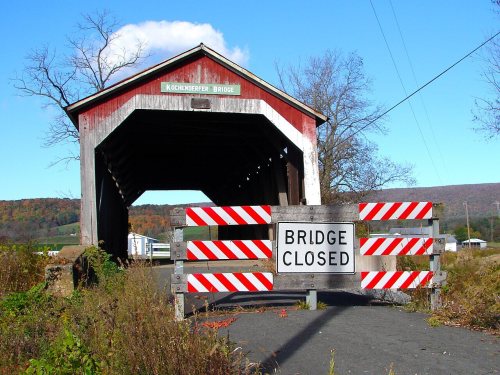
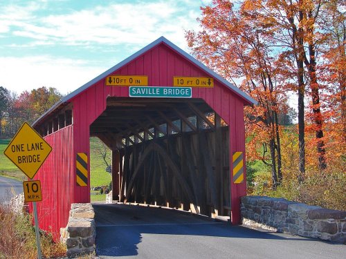
Two places: the Kochendefer Covered Bridge (listed 1980) and the Saville Covered Bridge (1980).
How old are the homes in Saville Township?
14% of Saville Township’s homes were built before 1940 (Census estimate, ±5.0 points), against a typical 18% for a Pennsylvania town; the median home was built in 1983.
Founding dates: Wikidata, Wikipedia, the U.S. post office records of Blevins & Helbock (CC0) and the Census. Homes by year built: Census ACS 2020–24. National Register of Historic Places: National Park Service (list of May 22, 2026). Old photos, postcards and papers: Wikimedia Commons, the Library of Congress and other public archives, credited on each item’s page. Maps: U.S. Geological Survey historical topographic maps (via Esri) and Sanborn fire-insurance maps (Library of Congress). History text and census tables: Wikipedia (CC BY-SA 4.0). Places that used to be: USGS Geographic Names Information System (2021).
From Wikidata (1), the National Register of Historic Places (2), Wikipedia, U.S. Geological Survey historical maps, the US Post Offices dataset (Blevins & Helbock), the USGS Geographic Names Information System and old county and town histories (Internet Archive). Archive images are copied here with their credits and licenses, shown on each photo’s page. Refreshed monthly.