Quakertown dates to 1700, and 26% of its homes were built before 1940
Among the most historic 1% of U.S. towns · #37 of 1,035 in Pennsylvania. What drives it
4 places in town are on the National Register, among them a historic district with 2,197 buildings. Below: 9 old photos and papers, maps from 1888 on, and the census since 1850.
Founding year: Wikidata. First post office: 1867.The full story ↓
History grade
What drives Quakertown’s History grade
On its age, its old homes and the National Register, Quakertown is among the most historic 1% of U.S. towns, #37 of 1,035 in Pennsylvania. All 3 inputs are above most U.S. towns; its National Register listings ranks highest and its share of homes from before 1940 lowest.
A+
HistoryA character grade: shown, never part of Quakertown’s overall grade.
Pennsylvania towns list about as much on the Register as the country (a typical Pennsylvania town has 2.1 per 10,000 residents, the U.S. 2.4), so Quakertown’s 2,362 sits above most of its state (99% of Pennsylvania towns have fewer) while its 2,201 historic buildings outnumber those of 99% of U.S. towns.
NoteThe founding year comes from Wikidata alone; no second source gives 1700.
How sure. Graded on any two of the three inputs instead, the letter would still be A+. The pre-1940 share is a Census survey estimate (±4.6 points).
Founding year: Wikidata (other dates in Quick answers). Homes: Census ACS 2020–24. National Register: National Park Service, May 2026 list; each listing counted once (boundary changes and added documentation belong to their listing), and a historic district counts its contributing buildings. How TownRatings grades history →
What stands out about Quakertown’s past
Read from the archive, the National Register and the record. The page puts what stands out first.
The region of Quakertown was initially referred to as the Great Swamp, a wilderness inhabited by Native Americans, specifically the Lenape tribe.
On September 18, 1777, during the American Revolutionary War, a convoy of wagons carrying the Liberty Bell from Philadelphia to Allentown, under the command of Col. Thomas Polk of Charlotte, North Carolina, stopped in Quakertown. The Liberty Bell was stored overnight behind the home of Evan Foulke (1237 West Broad Street), and the entourage stayed at the Red Lion Inn. The John Fries' Rebellion was also started in the Red Lion Inn in 1799.
Passages that mention Quakertown, cut from the printed page as they were published.
History of Bucks county, Pennsylvania, from the discovery of the Delaware to the present time1905 · page 441Read the page →
Read the text
tled on his father's farm. In 1864 he moved to Haycock township, near Applebachsville, where he farmed for one year. He then moved to Quakertown, near where the North Penn railroad .station now stands, and there raised and shipped stock to New York markets. In 1876 he purchased the Harry Hacket farm on Califor-
Text read by machine from the scan; it may contain errors.
The Lancaster family. A history of Thomas and Phebe Lancaster, of Bucks County, Pennsylvania, and their descendants, from 1711 to 1902. Also a sketch on the origin of the name and family in England1902Read the page →
Read the text
land to thi> meeting. The meeting house was then in the center of the settlement, but the town has since grown toward the east, so that it is now located at the western extremity of Quakertown, by which name the town is now known. In 1742, Richland Monthly Meeting was granted by the Gwynedd Monthly Meeting, and in 1741) an extension was made to the meeting house. It was again enlarged a few years later, and in
Text read by machine from the scan; it may contain errors.
History of Bucks county, Pennsylvania, from the discovery of the Delaware to the present time1905 · page 646Read the page →
Read the text
Landis, who was then in Europe, and in the spring of 1899 began practice for himself in Quakertown, where he was the only representative of the homoeopathic school. Notwithstanding indications of the unpopularity of that school w-ith the good people of Quakertown, Dr. Hedrick was successful, and has built up a large practice. In
Text read by machine from the scan; it may contain errors.
Scans and text from the Internet Archive. Books published in 1930 or earlier, which are in the public domain.
By decade
Quakertown, decade by decade
3 decades in the archive, from the 1880s to the 1960s. Scroll each row; tap a photo for its story.
Nothing in the archives for these yearsWeddings on Main Street, storms, parades, school pictures, the old store. If it’s in your family album, it belongs here.
Nothing in the archives for these yearsWeddings on Main Street, storms, parades, school pictures, the old store. If it’s in your family album, it belongs here.
Fire insurance maps drew every building, what it was made of and what it was used for, so insurers could price the risk of fire. Pick a year, then a sheet.
In 1700, according to Wikidata. Quakertown’s post office opened in 1867, and the census of 1850 counted 242 people here.
How does Quakertown rank for history?
Quakertown is among the most historic 1% of U.S. towns, #37 of 1,035 in Pennsylvania. The History grade combines the town’s founding era, the share of homes built before 1940 and its National Register listings. It’s a character grade, so it isn’t part of the overall grade. How it works.
What is on the National Register in Quakertown?
4 listings: 3 buildings, among them the Liberty Hall (listed 1978, the first), and 1 historic district, the Quakertown Historic District, with 2,197 contributing buildings. 2,201 historic buildings in all.
How old are the homes in Quakertown?
26% of Quakertown’s homes were built before 1940 (Census estimate, ±4.6 points), against a typical 18% for a Pennsylvania town; the median home was built in 1967.
Founding dates: Wikidata, Wikipedia, the U.S. post office records of Blevins & Helbock (CC0) and the Census. Homes by year built: Census ACS 2020–24. National Register of Historic Places: National Park Service (list of May 22, 2026). Old photos, postcards and papers: Wikimedia Commons, the Library of Congress and other public archives, credited on each item’s page. Maps: U.S. Geological Survey historical topographic maps (via Esri) and Sanborn fire-insurance maps (Library of Congress). History text and census tables: Wikipedia (CC BY-SA 4.0). Places that used to be: USGS Geographic Names Information System (2021).
From Wikimedia Commons (18), the National Register of Historic Places (4), Wikipedia, Wikidata and Wikipedia for famous people, U.S. Geological Survey historical maps, U.S. Census counts (via Wikipedia), the US Post Offices dataset (Blevins & Helbock), the USGS Geographic Names Information System, Sanborn fire insurance maps (Library of Congress) and old county and town histories (Internet Archive). Archive images are copied here with their credits and licenses, shown on each photo’s page. Refreshed monthly.


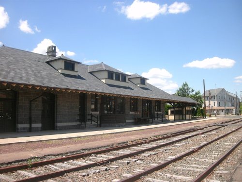


 1880
 c. 1930
 c. 1930
 c. 1930
 c. 1930
 c. 1930
 2012
 2012
 2012
 2009
 2009
 2009
 2009
 2009
 2006


